Best Base Camp Treks in Nepal
Base Camp of High mountains is a popular trekking destination in Nepal for adventurers and nature lovers. A base camp trek typically entails hiking to the base of a mountain or mountain range to see the peaks up close. Nepal is home to some of the world's highest mountains, including Mount Everest, and offers a variety of base camp treks to suit a variety of interests and fitness levels.
These treks typically include hiking through beautiful scenery, visiting small villages and monasteries, and learning about local culture and way of life. The length and difficulty of these treks vary, and they can take anywhere from a few days to a couple of weeks to complete.
Some of the most popular base camp treks in Nepal include
The best time to go trekking in Nepal's base camps depends on the trek you want to do as well as your personal preferences. However, for a variety of reasons, the most popular trekking seasons in Nepal are spring (March to May) and autumn (September to November).
The weather is usually mild and clear in the spring, and the mountains are visible. The rhododendrons, Nepal's national flower, are in full bloom, adding to the trek's beauty.
The temperature is pleasant during the day and can be cool at night. Autumn is also regarded as one of the best seasons for trekking in Nepal, owing to the generally clear weather and the end of the monsoon season. The skies are usually clear, and the views of the mountains are breathtaking. The monsoon season (June to August) is not recommended for trekking due to muddy and slippery trails and unpredictable weather.
Furthermore, the winter months (December to February) are not ideal for trekking in Nepal because temperatures can drop below freezing, and mountain passes can become snow-covered.
It is also important to note that if you plan to go trekking at higher elevations, you must be prepared for the cold, even if you visit in the spring or autumn. Always check the weather forecast and be prepared with the necessary equipment and clothing.
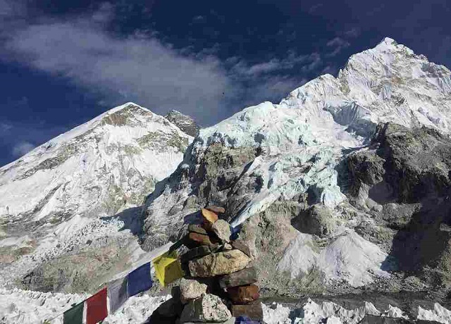
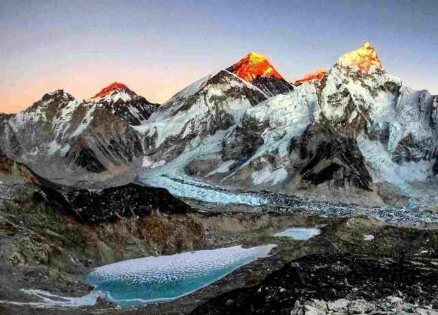
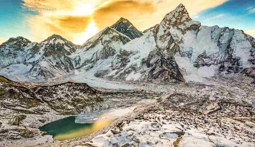
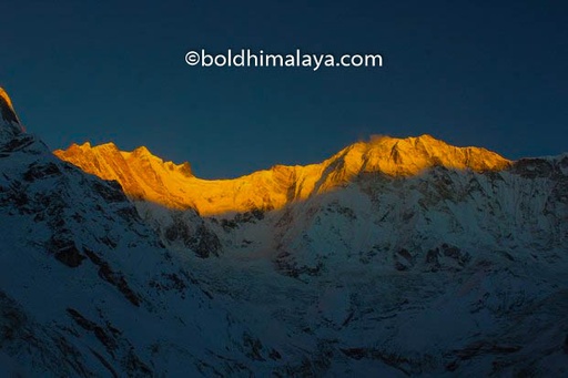
The Everest base camp trek is a once-in-a-lifetime adventure achievement for those whose dreams soar higher than the clouds. The journey begins in ancient Kathmandu, where you will acclimate and explore the city at your leisure before beginning your ascent.
Your journey to Everest Base Camp at 5,364m (over 3.5 miles!) will take you over suspension bridges spanning chasms of thin air, through hidden Buddhist monasteries, and into the heart of the warm, rugged Sherpa culture. You'll see Cho Oyu, Lhotse, and Makalu - three of the world's ten tallest peaks - as you travel with thrill seekers and photographers from all over the world.
Highlights
You will be able to look at Mount Everest's base and be in awe of its grandeur and magnitude.
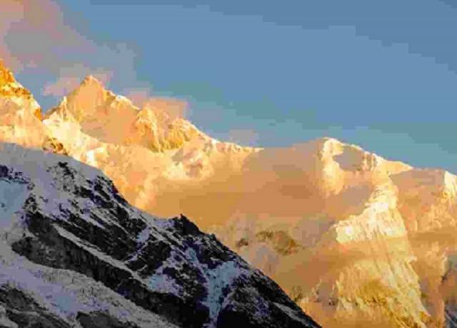
Visit Kalapatthar, referred to as the Everest viewpoint, to observe the sun setting over Everest.
Taking a flight to Lukla's high-altitude Hilary Tenzing Airport will be a wonderful experience.
Visit the yak herders and Tibetan-like villagers in Sherpa settlements. The Sherpa are Buddhist and their culture is heavily influenced by their religion. You will see traditional villages, monasteries, and stupas, and you may have the chance to interact with the local people and learn about their customs and beliefs.
As you trek through the region, you will see a variety of flora and fauna, including pine and juniper forests, rhododendrons, bamboo, and a variety of other trees and shrubs.
You may also see animals such as yaks, severalp, and a number of endangered species, including the snow leopard, red panda, and musk deer. Stay at Namche Bazaar, where all Everest treks depart from.
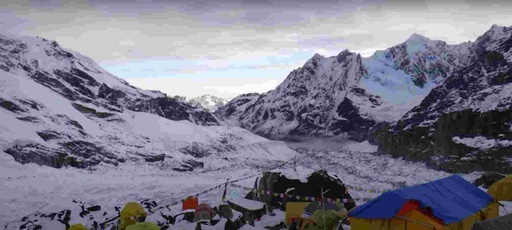
Be astounded by the icy splendor of the Khumbu Icefalls and Khumbu Glacier.
Visit Tengboche Monastery to experience its potent spiritual significance.
Difficulty Level
The Everest Base Camp Trek is considered a difficult trek, but it is doable for people who are physically fit and have a good level of fitness. The trek entails walking for several hours each day on rough terrain, and the altitude can be difficult for some. Kalapatthar, at an elevation of about 5,550 meters, is the trek's highest point (18,204 feet).
This is significantly higher than Mount Whitney, the highest point in the continental United States at 4,421 meters (14,505 feet). The thin air at high elevations can make it difficult to catch your breath and cause symptoms such as headache, fatigue, and shortness of breath.
Route of Everest Base Camp Trek
The trek typically starts in Lukla, a small town in the Solu-Khumbu region of Nepal, and follows the Dudh Kosi river through Sherpa villages and forests before reaching Namche Bazaar, the largest town in the region. From Namche, the route continues to Tengboche, Dingboche, and Lobuche before reaching the base camp at an altitude of 5,364 meters (17,598 feet).
From there you can go to Kala Pattar which is a popular destination for trekkers who are visiting the base camp Along the way, you will have the opportunity to visit Buddhist monasteries, learn about the culture and way of life of the local Sherpa people, and enjoy the stunning mountain scenery.
Trek Overview
Starting and end point: Lukla
Trekking type: Lodge to Lodge Trek
The highest altitude of the trek: are 5,550 meters
Best time to do this trek: Spring ( March, April, May) and Autumn (September, October, and November)
Average walking hours: 5 to 6 hours per day
Total trekking days: 10 to 14 days
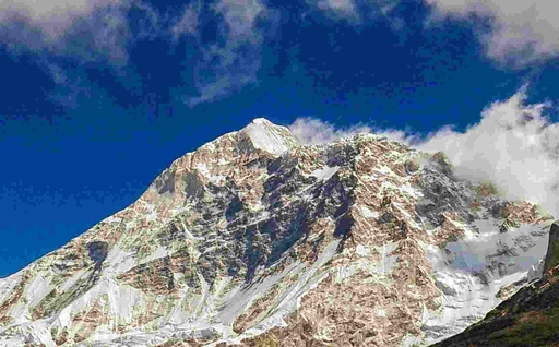
The Annapurna Base Camp Trek is arguably one of the most renowned and traditional treks in the world. It offers breathtaking mountain views and the chance to see typical Nepali villages, locals, and their way of life in the Himalayas of Nepal.
The trek is known for its stunning mountain views, including close-up views of Annapurna South, Hiunchuli, Gangapurna, and Machhapuchhre (Fishtail). The road to Annapurna Base Camp, the trip's final and most important stop, ascends through breathtaking and serene scenery, attractive Gurung and Magar communities, and lush green Rhododendron, bamboo, and alpine forests to a height of 4130 meters (13546ft.)
Highlights
Learn about the culture, traditions, and everyday habits of the Gurung people in Ghandruk village.
Follow the Modi Khola's waves as you stroll through woodlands filled with a variety of flora and fauna like Rhododendron forests, Pine and oak forests, as well as species like snow leopards, blue sheep, Yaks, and mules.
360-degree panorama of Machhapucchre Himal, Hiunchuli, Gangapurna, Annapurna I, and Annapurna South
You will be able to visit both Annapurna and Machhapucchre Base Camps at the same time
After returning from the base camp, unwind in the hot tub at Jhinu Danda.
Natural beauty, including waterfalls, terraced rice fields, and the Modi Khola Gorge.
A unique blend of natural beauty, cultural immersion, and mountain adventure.
Difficulty Level
The Annapurna Base Camp Trek is a moderate-difficult trek that is best suited to those with prior hiking experience. There is a lot of uphill and downhill hiking on the trek, with some steep and rocky sections.
The trek's highest point is 4,130 meters (13,550 feet) at Annapurna Base Camp, and the total distance traveled is approximately 70 kilometers (43 miles). While the trek is physically demanding, it is widely regarded as one of the more accessible treks in the Annapurna region due to the well-maintained trail and the numerous teahouses along the way where you can rest and replenish your energy.
Route of Annapurna Base Camp Trek
The Annapurna Base Camp Trek is a circular route that begins and ends in Pokhara, Nepal. It takes you through beautiful landscapes and traditional villages and culminates at the base camp of Annapurna South, one of the highest peaks in the world.
The trek starts in Nayapul, follows the Modi Khola River, and passes through Ghorepani, Poon Hill, Tadapani, and Jhinu Danda before returning to Nayapul. The total distance covered is around 70 kilometers (43 miles), with the maximum altitude reached being 4,130 meters (13,550 feet) at the Annapurna Base Camp.
Trek Overview
Starting and end point: Nayapul
Trekking type: Lodge to Lodge Trek
The highest altitude of the trek: 4,130 meters
Best time to do this trek: Spring ( March, April, May) and Autumn (September, October, and November)
Average walking hours: 5 to 7 hours per day
Total trekking days: 10 days
The Kanchenjunga Base Camp Trek is a challenging trek that takes place in the eastern Himalayas, in Nepal. It offers stunning views of Mount Kanchenjunga, the third-highest mountain in the world, as well as other peaks in the region.
The trek involves a strenuous hike through the remote Kanchenjunga Conservation Area, passing through dense forests, alpine meadows, and traditional villages. It is a relatively less-traveled route compared to other popular treks in Nepal, so you can expect a more authentic and immersive experience. The trek typically takes around 15-18 days to complete, depending on the route and pace of the group. It is recommended for experienced trekkers in good physical condition, as the high altitude and rugged terrain can be challenging.
Highlights
Discover Nepal's lesser-known Eastern mountainous regions.
The trek offers breathtaking views of the third-highest peak in the world Mount Kanchenjunga and other peaks in the region, including Mount Jannu, Makalu, and Lhotse.
The Kanchenjunga Conservation Area is home to a variety of animals, including Red pandas, musk deer, and snow leopards.
After your strenuous walks, practice meditation in Ramtang and Oktang Monasteries.
Traditional Nepalese and Tibetan cultures coexist here.
Amazing vistas, forests, rivers, and waterfalls are all part of the untouched, wild, and distant nature found here.
Explore several Glaciers. like the Yalung Glacier, the Kanchenjunga Glacier, and many others Many high passes, such as Sele La Pass (4290 meters), Mirginla Pass (4480 meters), and Sinelapcha Pass (4646) are crossed.
Difficulty level
The Kanchenjunga Base Camp Trek is a challenging trek that involves long days of hiking over steep and rocky trails in the high altitude of the eastern Himalayas in Nepal. It is recommended for experienced trekkers in good physical condition, and it is important to prepare by building up endurance and properly acclimatizing to the altitude before attempting the trek.
The trek can also be cold and wet at times, and basic comforts may be limited in the remote areas you will be passing through. The highest point of the trek is at an altitude of 5,140 meters (16,860 feet) at the base camp, which can be physically demanding for some people.
Route of Kanchenjunga Base Camp Trek
The Kanchenjunga Base Camp Trek typically begins in the town of Taplejung and follows a route through the Kanchenjunga Conservation Area, passing through several villages along the way such as Yamphudin, Tortong, and Tseram. The trek involves a challenging hike through dense forests, alpine meadows, and rugged terrain, with some sections requiring the use of fixed ropes for assistance.
The highest point of the trek is at Oktang, at an altitude of 4,830 meters (15,860 feet), before reaching the final destination of the Kanchenjunga Base Camp, located at an altitude of 5,140 meters (16,860 feet). The trek typically takes around 15-18 days to complete, depending on the route and pace of the group.
Trek Overview
Trek Starting and end point: Suketar
Trekking type: Lodge to Lodge Trek
The highest altitude of the trek: are 5,140 meters
Best time to do this trek: Spring ( March, April, May) and Autumn (September, October, and November)
Average Daily walking hours: 5 to 7 hours per day
Total trekking days: 15-18 days
Mount Makalu, the world's fifth-highest peak, as well as other nearby peaks, can be seen from the Makalu base camp trek. The hike will take you through the Makalu Barun National Park, where you will pass through thick woods, alpine meadows, and traditional communities.
In comparison to other well-known treks in Nepal, it is a less-traveled path, so you can expect a more authentic and immersive experience. The journey usually takes between 15 and 20 days to complete, depending on the terrain and group pace. It is recommended for experienced hikers in good physical condition due to the difficult terrain and high altitude. Depending on your pace, the trek can take up to two weeks to complete.
Highlights
The Makalu Base Camp Trek is less crowded and more remote than other popular Nepalese treks, making it a more authentic and immersive experience. Pass through the Shipton La pass as well as three other high passes.
The Rai and Sherpa communities, who have a rich cultural heritage and a deep connection to the mountains, typically inhabit the villages along the trek.
Stay in a tea house while traveling to experience distant village life and directly support the local economy.
Mount Makalu and other peaks in the region, such as Mount Everest, Lhotse, and Cho Oyu, can be seen from the trek.
The Makalu Barun National Park is home to a diverse range of wildlife, including rare and endangered species such as the red panda, snow leopard, and Himalayan black bear.
Along the way, the Makalu Base Camp Trek passes by several glaciers and waterfalls, including Lhonak Glacier, Yalung Glacier, Tuli Pokhari, Makalu Barun Waterfall, and Barun Glacier.
The difficulty level of Makalu base camp Trek
The trek to the natural wonderland is challenging. As a result of the trail's isolation, erratic weather patterns, high altitude passes, lack of hiking amenities, and shifting topography, the Makalu region is a desirable trekking destination with a complete package of stunning natural beauty. Trekkers with previous experience can hike to Makalu Base Camp without too many difficulties.
You shouldn't give up even if you are a rookie trekker. It is important to prepare by building up endurance and properly acclimatizing to the altitude before attempting the trek.
Route of Makalu Base Camp Trek
The Makalu Base Camp Trek typically begins in Tumlingtar and follows a route through the Makalu Barun National Park, passing through villages such as Num and Seduwa. The highest point of the trek is at the Makalu Base Camp, located at an altitude of 5,100 meters (16,730 feet), which is the final destination of the trek. The trek takes approximately 15-20 days to complete and involves a challenging hike through dense forests, alpine meadows, and rugged terrain.
Trek Overview Starting and end point: Tumlingtar Trekking type: Lodge to Lodge Trek Highest altitude of the trek: 5,100 meters Best time to do this trek: Spring ( March, April, May) and Autumn (September, October, and November) Average walking hours: 5 to 7 hours per day Total trekking days: 15-20 days
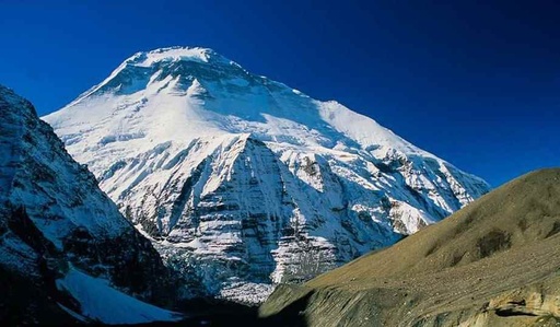
Dhaulagiri Base Camp Trek is a popular Nepalese trek that takes you to the base camp of Dhaulagiri, the world's seventh-highest mountain. As you make your way to the base camp, you will pass through villages, forests, and meadows. Ascending the French Pass (5360m) will test your endurance, but well-prepared acclimatization will make it easier. Hike through Hidden Valley, which is surrounded by snow-capped mountains and ruggedly desolate landscapes.
The Boudha Himal and Himal Chuli in the west, the Ganesh Himal in the south, and the Sringi Himal in the north border the Hidden Valley on one side. Along the way, you'll get to see stunning views of Dhaulagiri and other peaks in the region, as well as learn about the local culture and hospitality. The trek typically takes 10 to 12 days to complete, depending on your pace and route. The trek is difficult and best suited for experienced hikers in good physical condition, but the rewards of reaching the base camp are well worth the effort.
Highlights
Stunning panoramas of Dhaulagiri and other peaks that are higher than 7000 meters.
The base camp of Dhaulagiri is located at an altitude of 5,000 meters (16,400 feet) and offers stunning views of the mountain and the surrounding peaks.
The trek follows the Myagdi Khola river, which is surrounded by lush forests and terraced fields.
As you trek higher in elevation, the vegetation changes from subtropical to alpine.
In the lower elevations, you may see a variety of plants such as oak, rhododendron, and bamboo.
At higher elevations, you may see alpine meadows with grasses, herbs, and flowers such as primulas and blue poppies.
The French Pass is a high mountain pass located at an altitude of 5,360 meters (17,590 feet).
The pass offers panoramic views of the surrounding peaks and is a highlight of the trek.
Along the way, you will have the opportunity to stay in traditional villages and experience the culture and hospitality of the local people.
The Dhaulagiri region is home to a variety of wildlife, including Himalayan Thar, Himalayan black bear, and musk deer.
You may have the opportunity to spot some of these animals along the trek.
The difficulty
Difficulty level of Dhaulagiri Base Camp Trek
There is no doubt that the Dhaulagiri Base Camp Trek is a difficult trek due titshe its high altitude and difficult terrain. The trek's highest point is at the base camp, which is located at an elevation of around 5,200 meters (17,060 feet). The trek, which includes several days of hiking and ascending to high altitudes, can be physically demanding. To have a successful and safe trek, you must be the n good physical condition and properly acclimate. It is also advised to hire a reputable guide and company for the trek, as the route can be difficult to follow and some technical sections may necessitate the use of ropes.
Route to Dhaulagiri Base Camp Trek
The Dhaulagiri Base Camp Trek typically starts in Pokhara, Nepal, and follows the Kali Gandaki River Valley to Darbang. From Darbang, the route heads north towards the Dhaulagiri massif, passing through villages and forests before reaching the base camp at an elevation of around 5,200 meters (17,060 feet). Along the way, trekkers will have the opportunity to visit the Italian Base Camp and cross the French Pass, which is the highest point on the trek at an elevation of around 5,360 meters (17,590 feet). The trek then descends back to the Kali Gandaki River Valley and returns to Pokhara.
Trek Overview
Starting and end point: Pokhara
Trekking type: Lodge to Lodge Trek
Highest altitude of the trek: 5,200 meters
Best time to do this trek: Spring ( March, April, May) and Autumn (September, October, and November)
Average walking hours: 5 to 7 hours per day
Total trekking days: 14 to 21 days
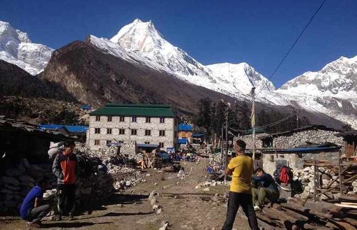
Manaslu (8167m) is the seventh-highest mountain in the world, and trekkers have only just started to explore this untamed region. Incomparable mountain views, secluded Buddhist settlements on the Tibetan border, and a level of cultural and geographic diversity unmatched by any other journey in the Himalayas may all be found in the Manaslu region. The Manaslu Circuit is truly unique. Along the steep-sided Budhi Gandaki river, the trek follows an ancient salt-trading route.
While trekking through the Manaslu region, ten peaks of more than 6,500 meters (21,300 feet) in height are visible, including peaks of more than 7,000 meters (23,000 feet). The journey starts in the foothills' subtropical forests and terraced farmland. As one climbs north, the scenery gradually changes into the dry, high-altitude landscapes that are connected to Tibetan culture. One of the highlights of this excursion is traveling to Manaslu's north and stopping by the expedition's Base Camp.
Highlights
View breathtaking mountain views, including Mount Manaslu, Annapurna II, and Lamjung Himal Discover the history and culture of the Sama Goan and Samdo communities.
As you make your way through isolated villages in Manaslu's direction, stop to take in the stunning panorama of peaks rising to 7,000 meters or higher.
The Manaslu Base Camp Trek passes through a variety of ecosystems, including forests, alpine meadows, and high-altitude passes.
Other plants that may be encountered on the trek include rhododendrons, pine forests, and alpine grasslands.
You will see the sweeping views of peaks like Himlung Himal (7126m) and Annapurna II. (7937m).
Experience the diverse cultures and landscapes of the isolated Buddhist communities near the Tibetan border. Numerous animals, such as Tahr, Agali, Pika, Himalayan Marmots, and if you're lucky, Snow Leopards.
The difficulty level of Manaslu Base Camp Trek
The Manaslu Loop The difficulty of a trek is typically rated as moderately demanding. To complete the Manaslu Circuit, hikers must navigate challenging terrain. The region's untamed and isolated landscapes necessitate a protracted stroll. Additionally, participants in the Manaslu Circuit need to maintain a threshold degree of fitness and stamina.
Before the travel, they must put in extensive preparation to get ready. This walk will be very difficult for first-time hikers. Acute mountain sickness, lengthy treks, etc. are other key challenge considerations. The difficulty level also greatly depends on the season for trekking and the unpredictability of the weather.
Route to Manaslu Base Camp Trek
The trek to Manaslu Base Camp begins in Kathmandu, Nepal, where you will likely spend a few days organizing your gear, obtaining permits, and meeting your guide. From Kathmandu, you will travel to Arughat and then to Soti Khola, which marks the beginning of the trek. From Soti Khola, you will follow the Budhi Gandaki river, trekking through various villages and across several suspension bridges along the way.
The route takes you through the Lho district, passing through villages such as Maccha Khola, Jagat, Deng, Namrung, and Lho. From Lho, you will continue your trek to Sama Gaon, and finally, to Manaslu Base Camp, which is located at the base of Mount Manaslu.
Trek Overview
Starting and end point: Arughat
Trekking type: Lodge to Lodge Trek
The highest altitude of the trek: 5,200 meters
Best time to do this trek: Spring ( March, April, May) and Autumn (September, October, and November)
Daily Average walking hours: 6 to 7 hours per day
Total trekking days: 12 to 15 days
Mardi Himal Base Camp Trek is a beautiful and relatively uncrowded trek in Nepal's Annapurna region. It provides breathtaking views of the Annapurna massif, including the famous peaks of Annapurna South, Hiunchuli, and Machhapuchhre, as well as the Mardi Himal itself. The trek is suitable for trekkers of all levels and can be completed in 5-6 days.
The trek to Mardi Himal Base Camp begins in Pokhara, a beautiful lakeside city in central Nepal. You will travel by vehicle from Pokhara to Kande, which marks the start of the trek. From Kande, you'll follow a well-marked trail through dense forests, past waterfalls, and across suspension bridges. Before reaching the Mardi Himal Base Camp, the route passes through several villages, including Deurali, Forest Camp, Low Camp, and High Camp.
Highlights
The surrounding mountains, including the Mardi Himal, Machhapucchre, Hiunchuli, and Annapurna, are visible from the trek.
You will have the opportunity to experience the local culture and hospitality of the Gurung people as you trek through the Annapurna region.
The trek allows visitors to see a wide range of flora and fauna, including rhododendrons, oak trees, and birds such as the Danphe pheasant, Nepal's national bird.
The opportunity to see the sunrise and sunset from the base camp is one of the main highlights of the Mardi Himal Base Camp Trek.
The base camp provides panoramic views of the surrounding mountains and is an excellent location for watching the sunrise and sunset.
The difficulty level of Mardi Himal Base Camp Trek
In terms of difficulty, the Mardi Himal Base Camp Trek is considered to be a moderate trek. The trek involves hiking for about 5-6 hours each day, and it involves some steep sections. It is important to be in good physical condition and to acclimatize properly to prevent altitude sickness. It is also essential to hire a local guide and obtain the necessary permits before embarking on the trek.
Route to Mardi Himal Base Camp Trek
The Mardi Himal Base Camp Trek starts in Pokhara, a beautiful lakeside city in central Nepal. You will travel by vehicle from Pokhara to Kande, the starting point of the trek.
From Kande, you'll take a well-marked trail through dense forests, past waterfalls, and across suspension bridges. Before reaching the Mardi Himal Base Camp, the route passes through several villages, including Deurali, Forest Camp, Low Camp, and High Camp.
Trek Overview
Starting and end point: Kande
Trekking type: Lodge to Lodge Trek
The highest altitude of the trek: 4500 meters
Best time to do this trek: Spring ( March, April, May), Autumn (September, October, and November), Winter (December, January, February)
Daily Average walking hours: 5 to 7 hours
Total trekking days: 6 to 9 days
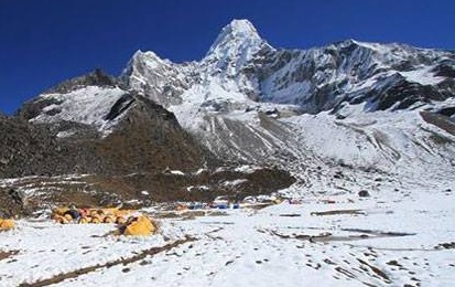
The trek to Ama Dablam base camp immerses you in Sherpa culture and the heart of Sherpa land. On the Everest Base Camp trail, you will travel for a while, but after Thyangboche, the trail bends to the east. Since there are no longer any herds on the trail, you can fully appreciate the stunning mountains that surround you. You will climb to the towns of Khumjung and Khunde following your visit to the Ama Dablam base camp of this gorgeously sculpted mountain. Here, you can go to the Edmund Hillary School, the local hospital in Khunde, and the Sherpa monastery of Khumjung.
Highlights
Beautiful views of Mount Ama Dablam and other famous peaks such as Mount Everest, Lhotse, and Nuptse.
Beautiful Sherpa villages and the chance to learn about the local culture and traditions.
Trails that will put your physical endurance and trekking skills to the test. Beautiful scenery with forests, rivers, and mountains.
The opportunity to visit the Ama Dablam Base Camp at an elevation of 4400 meters.
Tengboche Monastery is the famous oldest monastery in the Khumbu region.
The difficulty level of Ama Dablam Base Camp Trek
Due to its high altitude, rough terrain, and long daily hiking distances, the Ama Dablam Base Camp Trek is considered a moderate to difficult trek. It is recommended that trekkers be physically fit and mentally prepared for the challenges that come with high-altitude trekking. Some days may require up to 8 hours of hiking, with the highest point reached on the trek being around 5,300 meters (17,388 feet). To avoid altitude sickness, it is critical to properly acclimate and listen to your body. It is also critical to be properly equipped and prepared for the trek, which includes having the appropriate clothing, footwear, and equipment.
Route to Ama Dablam Base Camp Trek
The Ama Dablam Base Camp Trek typically begins with a flight to Kathmandu, Nepal, followed by a short drive to the village of Lukla, where the trek begins. From Lukla, the route follows the Dudh Kosi River, passing through the villages of Phakding and Namche Bazaar, and then continues on to Tengboche, Dingboche, and Lobuche.
From Lobuche, the route branches off to the east and heads towards the Ama Dablam Base Camp, passing through the villages of Pheriche and Debuche along the way. The base camp is located at the foot of Ama Dablam, a stunning Himalayan peak that towers over the surrounding landscape. The trek typically takes 7 to 14 days to complete, depending on the pace of the group and the number of rest days taken.
Trek Overview
Starting and end point: Lukla
Trekking type: Lodge to Lodge Trek
Highest altitude of the trek: 5,300 meters (17,388 feet)
Best time to do this trek: Spring ( March, April, May) and Autumn (September, October, and November)
Average walking hours: 6 to 8 hours per day
Total trekking days: 7 to 14 days
The Cho You Base Camp Trek is a challenging but rewarding trek through the heart of the Himalayas that takes you to the base of one of the world's highest peaks, Mount Cho You (also known as Cho Oyu). Located on the border between Nepal and Tibet, Cho Oyu is the sixth-highest mountain in the world, standing at an elevation of 8,188 meters (26,864 feet).
The trek offers stunning mountain views, the opportunity to visit traditional Sherpa villages and monasteries, and the chance to experience the rich culture and traditions of the local people. The trek is physically demanding and requires a good level of fitness, but the sense of accomplishment and the memories you'll make along the way make it all worth it.
Highlights
The Cho You Base Camp Trek provides unrivaled views of some of the world's highest peaks, including Cho Oyu, Lhotse, and Makalu.
The trek takes you through the Solu-Khumbu region, which is home to the Sherpa people, who are known for their rich culture and traditions.
You will have the opportunity to visit traditional villages and monasteries and learn about the local way of life.
The trek takes you through a variety of landscapes, from lush forests and terraced fields to rocky cliffs and glacial valleys.
You will be able to see Gokyo Lake. Visit Nepal's Sagarmatha National Park.
The Cho Oyu Base Camp Trek is a physically demanding trek that will test your endurance and determination, but the sense of accomplishment and memories you will make along the way will make it all worthwhile.
Difficulty level of Cho Oyu Base Camp Trek
Due to the high altitude and long daily hiking distances, it is considered a moderate to difficult trek. Some days may require up to 8 hours of hiking, with the highest point reached on the trek being around 5,000 meters (16,404 feet).
To avoid altitude sickness, it is critical to properly acclimate and listen to your body. It is also critical to be properly equipped and prepared for the trek, which includes having the appropriate clothing, footwear, and equipment.
Route to Cho Oyu Base Camp Trek
The Cho Oyu Base Camp Trek typically begins with a flight to Kathmandu, Nepal, followed by a short drive to the village of Lukla, where the trek begins. From Lukla, the route follows the Dudh Kosi River, passing through the villages of Phakding, Namche Bazaar, and Tengboche, before branching off towards the west and heading towards the Cho Oyu Base Camp.
The base camp is located at the foot of Cho Oyu, and the trek typically takes 7 to 14 days to complete, depending on the pace of the group and the number of rest days taken. Along the way, you'll have the opportunity to witness stunning mountain vistas, visit traditional Sherpa villages, and immerse yourself in the culture and way of life of the local people.
Trek Overview
Starting and end point: Lukla
Trekking type: Lodge to Lodge Trek
The highest altitude of the trek: 5,000 meters (16,404 feet)
Best time to do this trek: October to November and March to April
Average walking hours: 6 to 8 hours per day
Total trekking days: 7 to 14 days
The API Himal Base Camp Trek is a rigorous trek in the western region of Nepal that takes you to the base of API Himal, a mountain in the Himalayan range. The trek begins in the town of Tinker and takes you through beautiful forests, past waterfalls and streams, and across high passes with stunning views of the surrounding mountains.
Along the way, you will have the opportunity to visit local villages and meet the friendly people who call this region home. The trek typically takes about two weeks to complete, depending on your pace and the route you take. It is recommended for experienced trekkers in good physical condition.
Highlights
The trek provides close-up views of the Himalayan range, including Api (7,132 m) and other snow-capped peaks such as Mt. Kapchuli (6,850 m), Mt. Rajama (6,537 m), and Mt. Thado Dhunga Tuppa (5,368m).
The trek takes you through local villages, where you can learn about the people's culture and way of life.
The trail winds through forests, past waterfalls and streams, and across high passes with breathtaking views of the surrounding landscape.
The trek is physically demanding and requires excellent physical fitness.
It's a great way to push yourself and see where you can go.
Explore the holy lake of Kali Dhunga. Completing the Api Himal Base Camp Trek is a great accomplishment and an unforgettable experience.
Difficulty
level of Api Himal Base Camp Trek The Cho You Base Camp Trek's difficulty level is determined by a number of factors, including your physical fitness level, previous trekking experience, and the route you take. In general, the Cho You Base Camp Trek is regarded as a moderate to difficult trek, with some long and strenuous days of hiking.
The trek involves ascending and descending steep hills, and you may be required to walk for up to 7 hours per day. Before embarking on this journey, you must be in good physical condition. Having said that, the difficulty of the trek can be adjusted based on your pace and the route you take
Route to Api Himal Base Camp Trek
Beginning with a flight from Kathmandu to Dhangadhi, the API Base Camp hike begins. We will drive from Dhangadhi to Attariya, where the trek begins. The trek continues through Dhuli Odar, Ghusa, Simar, Khaikot, and Kali Dhunga before reaching Api Himal, which is the hike's highest point (7132 m). You will be captivated by the stunning Himalayan views, the area's abundant biodiversity, and the intriguing culture and way of life of the natives as you travel.
Trek Overview
Starting and end point: Attariya
Trekking type: Lodge to Lodge Trek
The highest altitude of the trek:4,800 meters (15,744 feet).
Best time to do this trek: September to November and March to May
Average walking hours: 6 to 8 hours per day
Total trekking days: 12-14 days
The Ganesh Himal Base Camp Trek is a beautiful and rewarding trek through the stunning Ganesh Himal region of central Nepal. The Ganesh Himal region, located just north of the Langtang National Park, is a lesser-known trekking destination that offers a more authentic and off-the-beaten-path experience.
The trek passes through a variety of landscapes, including rhododendron forests, bamboo forests, and alpine meadows, and culminates at the Ganesh Himal Base Camp, which is located at an elevation of about 4,100 meters (13,451 feet). You will be able to learn about the Tamang people's culture and way of life. Along the way, you'll get to see traditional Tamang villages, monasteries, and stupas, as well as a variety of flora and fauna.
Highlights
Beautiful views of the Ganesh Himal range, including peaks such as Ganesh I, II, III, and IV, as well as other surrounding peaks such as Langtang Lirung and Dorje Lakpa.
Opportunities to see a variety of flora and fauna, including rhododendron forests, bamboo forests, and a variety of wildlife such as pheasants and musk deer.
A chance to experience the culture and way of life of the Tamang people, who are the dominant ethnic group in the region.
You will have the opportunity to visit traditional Tamang villages, monasteries, and stupas.
An opportunity to visit the hot springs at Tatopani, which are believed to have medicinal properties.
The holy White and Black Lakes, as well as the famous Parvati Lake (Kunda) Several rivers, suspension bridges, Georges, waterfalls, and stone-powered mills can be found there.
The difficulty level of Ganesh Himal Base Camp Trek
The difficulty level of the Ganesh Himal Base Camp Trek is moderate to challenging, with daily hikes of 4-6 hours on average. The trek involves some steep ascents and descents, and you should be in good physical condition and have some prior trekking experience before attempting this trek. It is also important to properly acclimatize and follow proper safety precautions while on the trek.
Route to Ganesh Himal Base Camp Trek
The route of the Ganesh Himal Base Camp Trek typically begins with a drive from Kathmandu to the starting point at Dhunche. After that Trek from Dhunche to Sing Gompa, Thulo Dhunga, Cholang Pati, Bamboo, Dovan, Tatopani, Pangsang Pass, and then to There Pati, Bala Camp and finally to Ganesh Himal Base Camp (4,100 meters/13,451 feet). Follow the same route back to reach Dhunche.
Trek Overview
Starting and end point: Dhunche
Trekking type: Lodge to Lodge Trek
The highest altitude of the trek: 4,100 meters/13,451 feet
Best time to do this trek: September to November and March to May
Average walking hours: 4-6 hours per day
Total trekking days: 14-16 days
Compared to the Everest Base Camp Journey and the Annapurna Base Camp Trek, the Churen Himal Base Camp Trek is an off-the-beaten-path trek that is only visited by a small number of hikers. The Base Camp of Churen Himal is the destination of this amazing trip. The trek to the Churen Himal Base Camp provides a chance to visit the mostly unexplored and inaccessible areas.
Furthermore, the region continues to maintain a distinctive way of life unaffected by western culture. The trekker can experience Nepal's simple way of life thanks to its preserved culture and way of life. In addition to this, the breathtaking views of the mountains Dhaulagiri, Annapurna, Churen Himal (7371m), Gurja Himal, and many others entice hikers to complete this trek.
Several rivers and swift glacier streams can be found along the Churen Himal Trek route. While on this trip, you can see a variety of plants and fauna. You will pass through several ethnic villages while walking, including Gurja Village, Lumsang Village, and Dharapani Village.
Highlights
The Churen Himal Base Camp Trek offers breathtaking views of the Churen Himal range, which includes peaks such as Churen I (7,296 meters/23,951 feet), Churen II (7,109 meters/23,330 feet), Churen III (6,939 meters/22,788 feet), and Churen IV (6,586 meters/21,624 feet).
The Churen Himal Base Camp Trek takes you through the heart of the Tamang region, and you will have the opportunity to experience the culture and way of life of the Tamang people.
You will visit traditional Tamang villages, monasteries, and stupas, and learn about their customs and traditions. The Churen Himal Base Camp Trek takes you through a variety of landscapes, including rhododendron forests, bamboo forests, and alpine meadows.
You will have the opportunity to see a variety of flora and fauna along the way, including a variety of birds and animals such as pheasants, musk deer, and Himalayan Thar.
The Churen Himal Base Camp Trek is a challenging trek that requires a good level of physical fitness and prior trekking experience. However, the rewards of the trek are well worth the effort, with stunning views, and cultural experiences
Difficulty level of Churen Himal Base Camp Trek
The difficulty level Churen Himal Base Camp Trek is challenging. The daily hikes on the trek typically involve some steep ascents and descents and can range from 4-6 hours in length. The altitude of the trek also adds to the challenge, with the highest point being the Churen Himal Base Camp at an altitude of approximately 4,600 meters (15,092 feet).
It is recommended that you be in good physical condition and have some prior trekking experience before attempting this trek. Proper acclimatization and following proper safety precautions are also important to ensure a successful and enjoyable trek.
Route to Churen Himal Base Camp
Trek The trek begins in the town of Arughat, which is located in the Gorkha District of Nepal. After that the route follows the Budhi Gandaki River upstream, passing through several small villages and crossing several suspension bridges along the way to Manaslu Conservation Area.
From here, the route continues to the Gurung village of Lapubesi. The final destination of the trek is the Churen Himal Base Camp, which is located at the foot of the Churen Himal and offers stunning views of the surrounding peaks.
Trek Overview
Starting and end point: Arughat
Trekking type: Lodge to Lodge
Trek Highest altitude of the trek: 4,200 meters (13,780 feet)
Best time to do this trek: September to November and March to May
Average walking hours:5 to 7 hours per day
Total trekking days: 14-16 days
The stunning Mustang valley has the mysterious beauty of the Saribung pass. Its primary goal is to ascend the somewhat difficult Saribung pass (6063 meters). Upper Mustang and the remote Naar Phu valley were connected by the 2006 opening of the Saribung pass trek to foreign visitors.
It is a more captivating and adventurous walk because of the steep, rocky terrain and the passing through settlements with ethnically diverse residents. One has the opportunity to experience Upper Mustang and Naar Phu Valley trekking in one trip. The entire Saribung Pass Trek is completed by flying to Jomsom from the popular tourist destination of Pokhara.
The Upper Mustang Circuit and Damodar Himal ranges are traversed by the path in a magnificent route having the option to ascend the Saribung mountain while navigating the many high passes, notably Saribung Pass (6042m).
Highlights
The Saribung Himal is a beautiful and majestic mountain located in the Annapurna region of Nepal. As you trek towards the Saribung Base Camp, you will have the opportunity to view the mountain and other nearby peaks like Annapurna South (7,219 meters), Hiunchuli (6,441 meters), Gangapurna (7,455 meters) from various angles, offering breathtaking views of the surrounding landscape.
The Saribung Base Camp Trek passes through several small villages and offers the opportunity to learn about the culture and way of life of the local people.
The trek route includes a visit to the Tamang village of Chame, where you can learn about the history and customs of the Tamang people. The Saribung region is home to a variety of flora and fauna, including forests of rhododendron, oak, and pine.
As you trek through the region, you will have the opportunity to see these forests up close and marvel at their beauty.
The Saribung Base Camp Trek involves crossing several fast-flowing glacial streams, which are fed by the melting glaciers of the surrounding mountains. These streams provide a vital source of water for the local communities and ecosystems and offer a chance to experience the raw power of nature up close.
The Saribung region is home to a variety of unique flora and fauna, including rare species of birds and animals. As you trek through the region, you may have the opportunity to see some species like Himalayan Thar, Snow leopard, Musk deer, Blue sheep, etc in their natural habitat.
You'll get the opportunity to go to Luri Gompa Damodar Kunda.
The difficulty level of the Saribung base camp trek
The Saribung base camp trek is considered a moderate to challenging trek, depending on your level of fitness and experience. The trek involves hiking through rugged, mountainous terrain at high altitudes, and you can expect to walk for 6-8 hours per day. The trek includes some steep ascents and descents, and you will need to be physically fit and have a good level of endurance to complete it. That being said, the trek is suitable for fit and experienced hikers who are comfortable with long days of hiking and can adapt to high altitudes. The trek can be customized to suit your fitness level and pace, and you can take breaks or rest as needed along the way.
Route to Saribung base camp trek
The Saribung base camp trek begins in the town of Beni, which can be reached by bus or jeep from Kathmandu. From Beni, the trek follows a route through the Annapurna region, passing through the villages of Babiyachour, Dharapani, and Muri. The trek then continues through the high-altitude pass of Charkabhot and the village of Charkabhot, before reaching the Saribung base camp at an elevation of approximately 5,600 meters (18,372 feet).
Along the way, trekkers will have the chance to experience the stunning natural beauty of the Himalayas, including snow-capped peaks, lush forests, and cascading waterfalls.
Trek Overview
Starting and end point: Beni
Trekking type: Lodge to Lodge Trek
The highest altitude of the trek: 5,600 meters (18,372 feet)
Best time to do this trek: September to November and March to May
Average walking hours: 6 to 7 hours per day
Total trekking days: 8 to 10 days