| Manaslu Circuit Trek | Annapurna Circuit Trek |
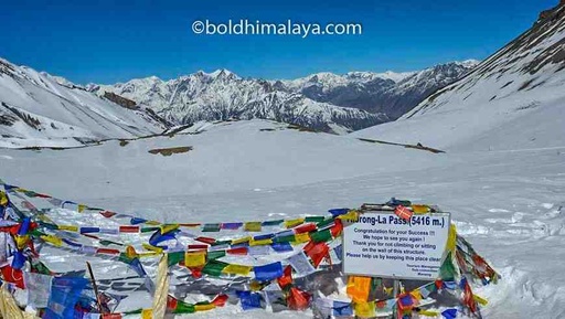
Maximum elevation | 5,100 meters (16,732 feet) at Larkey La Pass | 5,416 meters (17,769 feet) Thorong La Pass |
Major Attractions | Mount Manaslu, Larkya La Pass, Samagaon: Traditional Tibetan style villages, Ancient Monastery, Birendra Lake, Diverse landscapes, Tsum Valley (if include trek Tsum Valley as well)
(Annapurna and Manaslu Himalaya Ranges) | Most Diverse Landscape, Scenic Trekking Route Thorong La Pass, Muktinath (Hindu and Buddhist Pilgrimage site), Glacier lakes (Tilicho, Gangapurna, and Ice Lake Lake), Jomsom, Manang
(Annapurna and Dhaulagiri Himalaya ranges) |
Permits | A Restricted Area Permit, Manaslu Conservation Area Permit, and a TIMS card | TIMS (Trekkers' Information Management System) and ACAP (Annapurna Conservation Area Permit) |
Total days / Itinerary | 8-16 days | 9-17 days |
Things to see on the trek | you will see beautiful landscapes, including lush forests, mountain streams, and terraced fields, as well as traditional villages and monasteries like Sama gompa, Rachen gompa, sho gompa, Lho gompa | you can expect to see diverse landscapes and terrains, including lush forests, and rocky terrain, mountain ranges, traditional villages, and glaciers, rivers, waterfalls, Hindu and Buddhist temples, and monasteries. |
Difficulty Grade of the Trek | Manaslu Circuit Trek is considered a moderately to difficult grade trek of Nepal | The Annapurna Circuit Trek is considered a moderate to Difficult grade trek, due to the high elevation and the distance covered. |
Total distance | 180-190 km depending in Starting and Ending point | 160-230 km Depending i Star and Ending points |
Side expandable trekking routes | Annapurna Circuit trek, Tsum Valley trek | Tilicho Lake Trek, Nar Phu Valley Trek, Upper Mustang Trek |
Risk of altitude sickness | Due to the high altitude of the Manaslu Circuit Trek, trekkers may experience altitude sickness if not properly acclimatization. Headache, nausea, exhaustion, shortness of breath, appetite loss, sleeplessness, dizziness, and facial, hand, and foot edema are just a few of its symptoms.
Proper acclimatization is crucial for this trek.
| The Annapurna Circuit Trek may experience altitude sickness if not properly acclimatization, risk because its highest point, Thorong La Pass, is more than 5,400 meters above sea level. Acclimatizing correctly and being aware of altitude sickness symptoms is crucial. |
Trek cost | $800-$1300. depending on service level and trek duration | $750- 1600 depending on Hotel category, duration and service level |
Transportation | Ground Transportation Kathmandu to Arkhet (Around 5 hrs) and Dharapani to Beshisahar to Kathmandu (Around 7 hrs) | Kathmandu to Beshisahar Ground Transport (Around 5 hrs) Besishahar to Chame Jeep Drive 4hrs and Jomsom to Pokhara (Either flight 20m or 7 hrs drive) Similarly Pokhara to Kathmandu 20m Flight or 6hrs Drive
|
Trekking routes | The trek starts in the town of Arkhet follows the Budigandaki River and passes through traditional Gurung and Tibetan villages, lush forests, and high alpine meadows before reaching the Larkya La pass, which offers stunning views of the Himalayas.
The trek then descends to the village of Dharapani before ending in the city of Besisahar. | The trek leaves from the town of Besishahar and follows the Marsyangdi River, passing through Magar and Gurung traditional villages, lush subtropical forests, and terraced rice fields. After that, the trail ascends to the Thorong La pass, which provides breathtaking views of the Dhaulagiri and Annapurna mountain ranges. The journey ends in the city of Jomsom after passing the pass and descending to the revered Muktinath. |
Best time for the Trek | September to November and March to May | September to November and March to May |
Weather and Temperature on the trek | During the September-November period, the weather is generally dry and clear, making it the best time to trek in the region. The temperature during the day is mild, but it can get quite cold at night. During the March-May period, the weather is mild and the rhododendron flowers are in full bloom, making the trek an even more beautiful experience. However, it can be quite wet during this time, and trekkers should be prepared for rain and snow. | During the months of September to November and March to May, the weather is generally clear with good visibility, and moderate temperatures. During the winter months, the temperatures can drop significantly, with heavy snowfall at higher elevations, making the trek challenging. During the monsoon season, from June to August, the region receives heavy rainfall, making the trail muddy and slippery, and visibility may be poor. It's also the time when leeches are seen on the trail. |
Facilities in the Trek | Food: Food can be found at guesthouses and teahouses along the trail, but options may be limited and more basic compared to what you would find in a city.Accommodation: Guesthouses and teahouses provide accommodation along the trail, but they may be more basic and less comfortable than what you would find in a hotel. Electricity: Electricity may not be readily available in more remote areas of the trek, but some guesthouses may have a generator or solar power. Internet: Internet access is not widely available on the trail, and connection may be slow or non-existent in more remote areas. Hot Shower: Hot showers may not be available in more remote areas of the trail. Laundry: Laundry services may be available at some guesthouses, but it's best to bring enough clothes for the duration of the trek. Drinking water: Drinking water is available from streams and rivers, but it's recommended to use a water filter or purification tablets. ATM and Banks: ATMs and banks are not available on the trail, so it's important to bring enough cash for the duration of the trek. | Food: Food options are available in most towns and villages including local Nepali cuisine, as well as Western-style food. However, options may be limited in more remote areas.Accommodation: Accommodation is available in the form of teahouses and lodges in most towns and villages. Electricity and internet: these facilities are available in most places, but they may be limited in more remote areas. Some lodges and teahouses may offer to charge services for a fee. Hot shower: Hot shower facilities are available in some teahouses and lodges. They may also come at an additional cost. Laundry: Laundry services are available along the Annapurna Circuit trek, but they may be limited or not available in more remote areas. They may also come at an additional cost. Drinking water: Drinking water is available in most towns and villages along the Annapurna Circuit trek. ATM and Banks: these facilities are available in some places along the trek, but they may be limited or not available in more remote areas. |
Preparation required | Physical fitness and proper training Adequate gear and equipment Obtaining necessary permits and arranging for a guide and porters Acclimatization and planning for altitude sickness Researching and familiarizing with the itinerary, route, and local culture Obtaining travel and medical insurance Vaccinations and obtaining necessary medical clearances Packing appropriate clothing and supplies
| Physical fitness Acclimatization Researching the trek and being familiar with the route, facilities, and weather conditions can help you prepare better. Mental preparation Obtain necessary permits: Insurance Hiring a guide can be helpful because Guides will help you navigate the route, provide information about the area, and deal with any issues that may arise. |
Packing list for the Trek | Hiking boots Warm and waterproof clothing and shoes Sleeping bag and sleeping mat Headlamp or flashlight Water bottles and water purification tablets First-aid kit and personal medication Sunscreen and sunglasses Hat or beanie Warm gloves and thermal layers Down jacket Rain gear Personal hygiene items Camera and extra batteries Cash and credit card Travel documents and permits
| Warm clothing Rain gear: Waterproof jacket and pants, poncho, or umbrella. Hiking gear: Hiking boots, hiking poles, gaiters. Sleeping gear: Sleeping bag, sleeping pad, and a liner. Headlamp and spare batteries. First aid kit Personal hygiene items: Toothbrush, toothpaste, wet wipes, hand sanitizer, and toilet paper. Sunscreen and sunglasses. Snacks: Energy bars, nuts, dried fruit, and chocolate. Camera and extra batteries Passport, permits, and travel insurance documents Cash and credit cards Maps and guidebooks
|


