Best High Passes Treks in Nepal
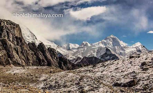
High passes trekking in Nepal refers to a type of trek that involves crossing high mountain passes, typically over 5,000 meters (16,411 feet) in altitude. These treks are popular among experienced trekkers and offer the opportunity to experience some of the most breathtaking and remote mountain scenery in the world.
Nepal is home to eight of the world's 14 highest peaks. So you will have many options available if you want to trek in the high passes of these high mountains.
Some popular high passes trekking routes in Nepal include:
Everest Three Pass Trek is one of the most rewarding difficult-grade trekking routes on the earth that takes you through the heart of the Himalayas, crossing three high mountain passes: the Renjo La, Cho La, and Kongma La and climbing to three high places viewpoint Kala Patthar, Gokyo RI, and Chhukung Ri.
The trek offers stunning views of many of the highest peaks in the world, including Mount Everest, and culminates with a visit to the base camp of the world's highest mountain.
Highlights of the Everest Three-Pass Trek
Trekking through the earth's renowned three high passes (Kongma La 5540m/18175ft, Cho La 5420m/17782ft, Renjo La 5360m/17585ft) at once
Great opportunity to experience a close View of Mount Everest 8848.86m/29031.7ft, Cho You, Lhotse, Makalu, and numerous high white mountains which are above 6000m
You will have the opportunity to visit the homes and towns of the local Sherpa people and learn about their way of life and culture.
Stunning views of High valleys, lakes, and gorges as well as high Himalaya flora and fauna.
An old monastery is one of Tengboche's UNESCO World Heritage Sites and Pangboche Monastery.
Syangboche Airport is the highest point, and Namche Bazaar is a well-known Sherpa village in the Everest region.
Chances to spot high Himalaya fauna such as Snow leopards, snow pheasants, musk deer, and the Himalayan Thar
Trekking through high places glaciers (Khumbu and Ngogumpa Glacier)
Climb to three viewpoints Chhukung Ri, Kala Patthar, and Gokyo Ri offers breathtaking vistas
The Everest Three Pass Trek is physically demanding and requires a good level of fitness. The trek involves hiking over rough terrain at high altitudes, with some steep ascents and descents.
The daily distances covered on the trek can range from 4-7 hours of walking, depending on the route and pace of the trek. In addition to the physical demands of the trek, the high altitude can also be a challenge for some people. It is important to be properly acclimatized to the high altitude to reduce the risk of altitude sickness.
Routes of Everest Three-Pass Trek
The Everest Three Pass Trek is typically done in about 14-18 days, depending on the route and pace of the trek. The trek typically begins in Lukla and follows the classic Everest Base Camp Trek route to Namche Bazaar. From Namche, the route diverges from the main trail and heads towards the Kongma La Pass.
After crossing the pass, trekkers continue to the Cho La Pass and then to the Renjo La Pass. The trek then joins the main trail to Gokyo and continues to the Base Camp before returning to Lukla. The trek can be done in either direction, and the route can be modified to suit the preferences and abilities of the trekkers.
Everest Three Pass Trek Overview
Starting and Ending Point: Lukla
Trekking Types: Lodge to Lodge Trekking
Highest Altitude of the Trek: 5555m Kalapather
Best Time to do Trek: Spring ( March, April, May) and Autumn (September, October, and November)
Average Walking hours: 4-7 Hours
According to traveler reviews and choice, the Annapurna Circuit Trek is the most popular trek on earth that takes trekkers around the Annapurna massif. Trekking from 800m via 5416m to the Himalayas rain shadow offers the most diverse landscape of the Hilly and Himalayas regions.
Highlights of Annapurna Circuit Trek
Stunning mountain scenery: The Annapurna Circuit Trek offers breathtaking views of the Annapurna massif, including, Annapurna I (8,091 meters/26,545 feet)
Trekking Through stunning three glacier lakes Gangapurna, Ice Lake, and Tilicho lake.
The trek passes through various community people which is a chance to learn, allowing you to learn about their mixed culture and way of life.
The Thorong La Pass (5,416 meters/17,769 feet) is the highest point on the Annapurna Circuit Trek and offers panoramic views of the surrounding mountains.
The opportunity to experience the many Buddhist monasteries as well as the biggest monastery in the Manang district at Bhakra and Muktinath sacred Hindu and Buddhist sites
The Annapurna Circuit Trek is a quite challenging trek that involves long days of hiking at high altitudes, with the Thorong La Pass reaching an elevation of 5,416 meters (17,769 feet).
The trek has steep and uneven terrain and can take anywhere from 12 to 21 days to complete, depending on the route and the pace of the trekkers. That being said, the Annapurna Circuit Trek is doable for most people who are in good physical shape and properly acclimatized to the altitude. It is important to train and prepare for the physical demands of the trek, and to take acclimatization days as needed to help your body adjust to the altitude.
Route of Annapurna Circuit Trek
The Annapurna Circuit Trek is a circular route that starts and ends in the city of Pokhara, in the Annapurna region of Nepal. The trek typically takes 12 to 21 days to complete, depending on the route and the pace of the trekkers.
The route typically follows the Marsyangdi River from Pokhara to the village of Chame. From Chame, the route heads north, passing through the villages of Pisang and Manang, and crossing the Thorong La Pass (5,416 meters/17,769 feet) before reaching the holy site of Muktinath. The trek then continues to Jomsom and back to Pokhara, or can be extended to visit the base camp of Annapurna South (7,219 meters/23,684 feet).
Annapurna Circuit Trek Overview
Trek Starting and Ending Point: Beshisahar and Jomson
Highest Altitude: Throng La Pass 5416m
Trekking Days: 11 to 17 Days
Trekking Types: Lodge to Lodge Trek
Average Daily walking hours: 5-7 Hours
Best Time: Spring (March, April, May) and Autumn (September October, and November)
Manaslu Circuit Trek is one of the most popular restricted area treks in the Manaslu region of Nepal that takes trekkers around the eighth-highest mountain in the world, Manaslu (8,156 meters/26,759 feet).
The trek follows a circular route that starts and ends in the city of Arughat and takes trekkers through the Budhi Gandaki valley, past traditional villages, and through a variety of landscapes, including subtropical forests, high-altitude deserts, and glacial moraines.
Highlights of Manaslu Circuit Trek
many insights from Tibetan and Nepalese people Valley of the exotic Budhi Gandaki River Beautiful views of Mt. Manaslu, Mt. Himchuli, Mt. Ganesh, and other mountains Larkya La pass (5153m/16901ft) crossing is one of the highest passes in the world.
Nuri culture in Tibet, which borders Nepal and Tibet Preserved environments and cultures Manaslu Circuit Trek is doable for most people who are in good physical shape and properly acclimatized to the altitude.
It is important to train and prepare for the physical demands of the trek, and to take acclimatization days as needed to help your body adjust to the altitude. It involves hiking at high altitudes, with the Larkya La Pass reaching an elevation of 5,106 meters (16,752 feet). It is also important to be prepared for the challenges of trekking in a remote mountain region, such as changes in weather and the potential for altitude sickness.
Route of Manaslu Circuit Trek
The Manaslu Circuit Trek follows a circular route that starts from Arkhet and ends at Dharapani in the Manaslu region of Nepal. The trek typically takes around two weeks to complete.
The route follows the Budhi Gandaki river from Arughat, passing through the villages of Soti Khola, Machha Khola, and Jagat, and crossing the Larke La Pass (5,106 meters/16,752 feet) before reaching the village of Bhimtang. Before crossing the Larkey La Pass the route passes through Namrung, Samagaun, and Samdo culturally and spiritually rich regions with ancient monasteries and beautiful landscapes.
The trek follows the Budhi Gandaki river to till the Larkey La Pass, passing through the villages trekkers can join Tsum Valley Trek before heading to Namrung, Prok, and Samagaon.
Overview of Manaslu Circuit Trek
Trek Starting and Ending Point: Aarughat and Dharapani
Trekking Type: Lodge to Lodge Trek
Highest Altitude of The Trek: 5106m/16752ft
Day Average Walking Hours: 5-7 Hours
Trekking Days: 9 to 14 Days
Best Time for the Trek: Spring (March, April, May) and Autumn( September October, and November)
The Ganja La Pass Trek is a challenging trek in the Langtang region of Nepal that takes trekkers over the Ganja La Pass (5,122 meters/16,802 feet), offering stunning views of the Himalayas and the opportunity to visit the Langtang National Park, home to a variety of flora and fauna. Ganga La Pass conect two popular trekking region Langtang Valley and Helambu.
Highlights of Ganja La Pass Trek
Stunning views of the Langtang Lirung Glacier and surrounding peaks
Cultural immersion in traditional villages and past monasteries
High-altitude adventure at an altitude of 5,122 meters (16,800 feet)
Diverse landscape including alpine forests, grassy meadows, and rocky cliffs
Opportunity to see wildlife such as the endangered red panda and Himalayan black bear
A unique blend of natural beauty, cultural experiences, and high-altitude adventure.
Visits to Kyangiin Monastery and Langtang Village Kyangjin Ri's panoramic view of the mountain
Red pandas, snow leopards, musk deer, bears, langurs, and other animals.
The trek involves a lot of walking on steep and rocky trails and can be physically challenging, especially at high altitudes. The pass sits at an elevation of 5,106 meters (16,752 feet), and trekkers will need to be prepared for the thin air and the risk of altitude sickness.
In addition to the physical challenges, trekkers may also face difficulties related to the weather, which can be unpredictable in the Himalayas.
Overall, the Ganja La Pass trek is considered to be of moderate to challenging difficulty. It is important to be in good physical condition and to properly prepare for the trek to ensure a safe and enjoyable experience.
Route of Ganja La Pass Trek
The trek can typically be completed in 7-12 days, but this can vary based on factors such as your level of fitness and the weather. The trek typically starts in the village of Syabrubesi, where trekkers can take a bus or a jeep from Kathmandu, and follows the Langtang Lirung Glacier to the village of Langtang, passing through the Langtang Valley and the village of Kyangjin Gompa along the way. From Langtang, the route heads north, crossing the Ganja La Pass and continuing to the Shermathang via Ghyang and Dukpu.
Ganja La Pass Trek Overview
Starting and Ending Point: Shyaprubeshi and Shermathang
Trekking Types: Lodge to Lodge Trekking
Highest Altitude of the Trek: 5122m Ganja La Pass
Best Time to do Trek: Spring ( March, April, May) and Autumn (September, October, and November)
Average Walking hours: 4-7 Hours
Total Trekking Days: 7 to 12 Days
Kanchenjunga Circuit Trek is a long popular high pass trek in the eastern region of Nepal, which takes you to the two base camps (South and North) of Mount Kanchenjunga, the third-highest mountain in the world.
The trek follows a circuitous route through the Kanchenjunga Conservation Area, passing through a variety of landscapes and cultures, including alpine forests, grassy meadows, and traditional villages. Along the way, trekkers have the opportunity to see an abundance of wildlife, including the rare snow leopard, and to experience the culture and hospitality of the local communities.
Highlights of Kanchenjunga Base Camp Trek
Discover Nepal's lesser-known Eastern mountainous areas.
It takes you to the base camp of Kanchanjunga, the third-highest mountain in the world.
The trek offers stunning views of the Himalayas, including Makalu, Lhotse, and Kanchenjunga.
After your strenuous walks, meditate at the monasteries of Ramtang and Oktang.
Along the way, you will pass through dense forests, high alpine meadows, and quaint villages.
The trek provides an opportunity to explore the diverse culture and traditions of the local communities.
The Kanchanjunga Circuit Trek is a challenging trek that requires proper physical fitness and endurance.
The trek involves long days of hiking, sometimes up to 8 hours per day, at high altitudes, reaching up to 5,180 meters (17,000 feet) at its highest point. The trek also involves traversing rocky trails and crossing streams and rivers, and the weather in the Himalayas can be unpredictable, with rain, snow, and strong winds possible at any time.
Overall, the Kanchanjunga Circuit Trek is considered a difficult trek that is best suited for experienced trekkers in good physical condition. To be properly prepared for the Kanchanjunga Circuit Trek, it is important to build up your physical fitness, acclimatize to the altitude, pack appropriately, and stay hydrated during the journey.
Route of Kanchenjunga Circuit Trek
The most popular route for the Kanchanjunga Circuit Trek is the standard route, which takes around 17-20 days to complete. This route begins in Taplejung and takes you to the base camp of Kanchanjunga, passing through forests, alpine meadows, and villages along the way.
The standard route is the most well-known and established route for the Kanchanjunga Circuit Trek, and it offers a good balance of challenging hiking and cultural immersion.
Along the way, you will have the opportunity to see some of the most stunning views of the Himalayas, including Makalu, Lhotse, and Kanchenjunga, as well as a chance to explore the diverse culture and traditions of the local communities.
Kanchanjunga Circuit Trek Overview
Starting and Ending Point: Taplejung
Trekking Types: Lodge to Lodge
Trekking Highest Altitude of the Trek: 5140m Kangchenjunga Base Camp
Best Time to do Trek: Spring ( March, April, May) and Autumn (September, October, and November)
Average Walking hours: 4-7 Hours
Total Trekking Days: 17 to 20 Days
Lower Dolpo Circuit Trek is a unique and rewarding trek in the western region of Nepal that crossed two high passes (Numa La and Baga La) and takes you through the beautiful and remote Dolpo region.
The trek offers stunning views of the Himalayas, including Dhaulagiri, Annapurna, and the Tibetan plateau, as well as a chance to explore the rich culture and traditions of the local communities. Along the way, you will pass through forests, alpine meadows, and villages, and have the opportunity to see a variety of flora and fauna, including rare species of birds and animals.
Highlights
It takes you through the unexplored lower and restricted areas of the Dolpo region.
The trek offers stunning views of the Himalayas, including Dhaulagiri, Annapurna, and the Tibetan plateau.
The trek provides an opportunity to explore the rich culture and traditions of the local communities.
The culture of Lower Dolpo also includes a strong tradition of Tibetan Buddhism, and the region is home to several monasteries and religious sites that are important to the local people.
You will have the chance to see a variety of flora and fauna, including rare species of endangered birds and animals like the Nepal Wren-Babbler, the Himalayan Monal, the Golden Eagle, Himalayan Snowcock, Lammergeier, Griffon Vulture, Snow Leopard, and the Blue Sheep.
Witness the traditional Practices of Bon Buddhism in various monasteries With a ticket to the Phoksundo National Park, hike to the pristine Shey Phoksundo.
Get to travel along the historic salt trade route while seeing the alluring scenery of the Yak Caravan.
Although everyone can complete this trek with good preparation this trek is considered a challenging trek that is best suited for experienced trekkers in good physical condition. The trek involves long days of hiking and camping at high altitudes, reaching up to 5,200 meters (17,000 feet) at its highest point. The trek also involves rough terrain, including rocky trails and narrow passes, which can be difficult to navigate. In addition, the weather in the Himalayas can be unpredictable, with rain, snow, and strong winds possible at any time, which can make the trek more difficult and potentially dangerous.
Route to Lower Dolpo Circuit Trek
Generally, it takes 19 days to complete this trek. The Lower Dolpo Circuit Trek typically begins in Kathmandu, where you will fly to Nepalgunj and then to Juphal, the starting point for the trek. From Juphal, the trek takes you through the beautiful and remote Dolpo region, passing through forests, alpine meadows, and villages along the way. You will have the opportunity to see stunning views of the Himalayas and explore the rich culture and traditions of the local communities. The trek reaches its highest point at Yalbang La Pass (5,200 meters) before returning to Juphal and flying back to Nepalgunj and Kathmandu.
Trek Overview
Starting and end point: Juphal
Trekking type: Tented Camping Trek
The highest altitude of the trek: 5,190 meters Numa La Pass
Best time to do this trek: Spring ( March, April, May) and Autumn (September, October, and November) Average walking hours: 6 to 7 hours per day Total trekking days: 19 days
Dhaulagiri Circuit Trek is a demanding and rewarding trek that rounds the base of Dhaulagiri, the seventh-highest mountain in the world, in the western part of Nepal. The trek provides the opportunity to see the rich culture and customs of the local populations as well as breathtaking vistas of the Himalayas, including Dhaulagiri, Annapurna, and the Tibetan plateau.
Highlights of Dhaulagiri Circuit Trek
The remote trail goes to historic settlements like Dharapani, Phaliyagaon, Muri, Lipsaba, and Dobhan Kharka, among others.
Observe Dhaulagiri I, II, III, and V in all their magnificence from Italian Base Camp and Glacier Camp.
On the approach to Dhaulagiri Base Camp, the Chhongardan Glacier is a breathtaking sight.
From Dhaulagiri Base Camp, take in a breathtaking vista of the Dhaulagiri range.
The trek provides an opportunity to explore the rich culture and traditions of the local communities.
You will have the chance to see a variety of flora and fauna, including rare species of birds and animals like the Wren-Babbler, the Himalayan Monal, the Golden Eagle, the Himalayan Snowcock, the Lammergeier, the Griffon Vulture, the Snow Leopard, Blue Sheep.
Trekking route alongside beautiful rivers, cascading waterfalls, and charming villages Trek through one of the world's deepest canyons, the Kali Gandaki Gorge.
A challenging journey, the Dhaulagiri Circuit is best suited for hikers with prior experience walking at elevations above 5,000 m. Without a simple way to descend, three days in a row are spent walking through snow over 5,000 meters. The weather can also be harsh, with cold temperatures and the possibility of snow and ice. Although the Dhaulagiri Circuit trip is not recommended for inexperienced trekkers or first-time tourists to Nepal, the rewards are substantial.
Route to Dhaulagiri Circuit Trek
It is a multiple-week trekking journey. The Dhaulagiri Circuit Trek begins in Beni and follows the Myagdi Khola river valley to Darbang. From Darbang, the trek passes through several small villages and reaches Dhaulagiri Base Camp at an elevation of 5,000 meters.
From the base camp, trekkers can either return or climb over French Pass (5,360 meters) and descend toward the Hidden Valley. The trek ends in Jomsom, from where trekkers go back to Pokhara and return to Kathmandu to complete the journey.
Trek Overview
Starting and end point: Beni and Jomsom
Trekking type: Lodge and Camping Trek
The highest altitude of the trek: 5,360 meters French Pass
Best time to do this trek: Spring ( March, April, May) and Autumn (September, October, and November)
Average walking hours: 5 to 7 hours per day
Total trekking days: 20-22 days
In Nepal's Dolpo region, there is a difficult and far-flung trip known as the Upper Dolpo Trek. The walk takes you through the high, remote Dolpo region, which is situated in the Dhaulagiri massif's rain shadow. The walk traverses through traditional Tibetan towns, historic monasteries, and high passes while providing breathtaking vistas of the Himalayan peaks, including Dhaulagiri.
Highlights
It is a unique trekking region because of its location on the northern side of the Himalayan range.
Trekking into isolated, highest mountains of the Dhaulagiri range.
Learn about the distinctive way of life and culture of the mountain people.
The people who live in Upper Dolpo are primarily Tibetan Buddhists, and their culture is deeply influenced by their religion.
You can visit the renowned Shey Gompa.
Explore the other magnificent monasteries like Phoskor Gompa, Tarap Gompa, Yara Gompa, and Chharka Gompa and learn about their long history of construction.
Unlike other high pass treks here you can trek during monsoon season. The unique location of upper Dolpo alters the climatic condition of this place making it receive less rainfall than other places. Upper Dolpo is a difficult region to hike across.
There are challenging ascents, three passes over 5000 meters, and numerous nights spent above 3500 meters. And a few extended, six-hour or longer trekking days. The weather can also be harsh, with cold temperatures and the possibility of snow and ice. Overall, the Upper Dolpo Trek is not suitable for inexperienced trekkers and should only be attempted by those who are in good physical shape and have some previous trekking experience.
Route to Upper Dolpo Trek
Usually, it takes 21 days to complete the trek but the length of the trek also depends upon factors like the fitness, experience, and pace of the trekkers. The Upper Dolpo Trek begins with a flight to Juphal and follows the Thuli Bheri river, passing through villages and crossing the Numa La pass (5402 meters).
The trek then continues to Phoksundo Lake and Shey Gompa before crossing Kang La pass and ending in Jomsom. From Jomsom, trekkers fly back to Pokhara and return to Kathmandu to complete the journey.
Trek Overview
Starting and end point: Jhupal and Jomsom
Trekking type: Lodge to Lodge Trek
The highest altitude of the trek: 5,402 meters
Best times to do this trek: Spring ( April, May) Rainy (June, August), and Autumn (September, October) Monsoon(June, July, and August) Average walking hours: 5 to 7 hours per day Total trekking days: 21 days
The Tashi Lapcha Pass Trek is a moderate to challenging trek in the Solu-Khumbu region of Nepal, also known as the Everest region. The trek takes you through the beautiful and culturally rich region of Solu-Khumbu, home to the famous Sherpa people. From the trek, you can also see the Jugal Himal, Rolwaling range, Gaurishanker, Mahalangur, Parchamo peak, Chobabhamre, and other mountains.
Highlights
The Ramdung Go training peak and the Yalung Glacier (5930m)
Opportunity to Visit the restricted area region of the Rolwaling area.
Gaurishankar Conservation Area should be explored.
Visit Tsho Rolpa Lake (4540m), Nepal's greatest glacier lake.
Observations of Mount Gaurishankar (7134m) Take a stroll in the Everest region.
Wide range of cultures you can expect to see rhododendrons, orchids, and other alpine flowers
You will see a variety of animals on the Tashi Lapcha Pass Trek, including pikas, and Himalayan tahrs.
You will pass by stunning cantilever bridges on this tour. Learn about Buddhism and the ancient way of life.
The TashiLapcha Pass is moderately difficult, and it is usually covered in snow. seasoned trekkers who have performed high-altitude hikes and are in good physical shape are preferred to do it. The high altitude and the high Tashi Lapcha Pass make the Rolwaling Tashi Lapcha Pass Trek more difficult and exciting. There's a considerable risk you'll have altitude sickness if you climb to a higher altitude. On the other hand, by properly acclimating, trekkers can avoid sickness.
Route to Tashi Lapcha Pass Trek
The duration of this trek is 18 days typically. The Tashi Lapcha Pass Trek begins with a flight to Lukla and follows the Dudh Koshi river, passing through the villages of Namche Bazaar and Tengboche. The trek then continues to Pheriche and crosses the Cho La pass (5,420 meters) before reaching the Tashi Lapcha Pass (5,755 meters). From the pass, the trek descends to Thame and ends in Namche Bazaar, from where you can fly back to Kathmandu to complete the trek.
Trek Overview
Starting and end point: Sigati and Lukla
Trekking type: Lodge to Lodge Trek
The highest altitude of the trek: 5,755 meters
Best time to do this trek: Spring ( March, April, May) and Autumn (September, October, and November)
Average walking hours: 6 to 7 hours per day
Total trekking days: 18 to 20 days
What is the best time to go on above mentioned treks?
The best seasons for trekking in these high Passes are the spring (March to May) and the fall (September to November). During these times, the weather is generally stable, with clear skies and moderate temperatures.
The spring season is known for its clear views and colorful rhododendron flowers. The fall season is known for its clear views and colorful autumn foliage. We recommend you do not go trekking in the winter and monsoon seasons in these high passes because, in the winter season (December to February), the high passes of the trek are likely to be covered in snow, making them more difficult and potentially very difficult to cross.
During the monsoon season (June to August), the heavy rains can cause landslides and make the trails slippery and dangerous. Although you can go trekking in the upper Dolpo circuit during monsoon because of its unique location. This region is situated on the other side of the Himalayan range which alters the climatic condition of this place making it receive less rainfall than other places.
What is the high passes trek mean?
The High Passes Trek is the trek that passes between two high mountains generally around 5000m and above.
Which is the Highest High Passes Trek in Nepal?
Amphu Lapcha Pass 5845m/19176.5ft is the highest passes trek of Nepal that lies in the Upper Hongu Valley between Sagarmatha and Makalu Barun National Park
Which is the most popular high Pass Trek in Nepal?
Annapurna Circuit Trek is the most popular high pass trek of Nepal where every year thousand of trekkers crosses the Thorong La Pass 5416m