


Kailash Mansarovar Yatra: A Complete Guide to Routes, Cost & Itinerary
-
 Bold Himalaya
 -
24 November, 2025
-
62 mins read
-
429 Views
-
0 Comments
Introduction: The Journey to Lord Shiva's Abode
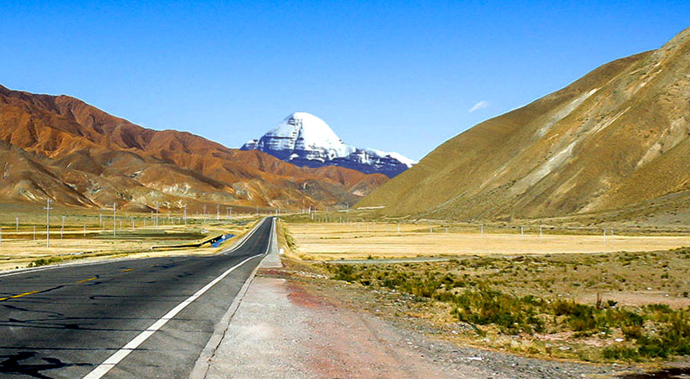
The wind in Darchen flaps the prayer flags like restless water. People pause toward the sharp tip of Mount Kailash - some crying, while others just breathe quietly. It rises to 6,638 meters; no one’s reached the top not due to skill limits, but out of deep respect across four big faiths. Here, every year, crowds start their spiritual walk known as the Kailash Mansarovar Yatra.
The Yatra’s more than just travel - it shifts something deep inside. Hindus see Mount Kailash as home to Lord Shiva, who meditates there forever alongside Parvati. Buddhists view it differently - as a real-world version of sacred Mount Meru, the heart of all existence. For Jains, this place holds weight because Rishabhadeva, their first enlightened teacher, broke free from life and death at Ashtapad near Kailash. Tibet’s old Bon tradition believes the peak is where spiritual energy begins, since their leader Thonpa Shenrab Miwo came down from the sky.”.
Each year, countless followers journey on the Kailash Mansarovar Yatra — not just for cleansing past wrongs but also seeking rebirth through ritual travel around its slopes - believers say this trek matters more than any other path they might walk.
Understanding Mount Kailash: The Sacred Geography
The Mountain That Four Religions Revere
Over in far-western Tibet, part of China, you’ll find Mount Kailash, the centerpiece of the Kailash Mansarovar Yatra, rising sharply with a sharp, pyramid-like top. What makes the Mount Kailash trek impressive isn’t how tall it is - plenty of Himalayan mountains are taller - but that it stands alone, with steep sides facing each direction: north, south, east, west. Pilgrims on this Kailash trip travel from all corners of the world to perform the sacred Parikrama, circling Kailash Parvat as part of their spiritual journey.
To understand the unique structure of this holy peak, you can also read about The Four Sacred Faces of Mount Kailash — each face holding different spiritual meanings across Hindu, Buddhist, Jain, and Bon traditions.
In the Vishnu Purana, every face is crafted from unique gems: crystal on the southern side, ruby toward the west, gold to the north, also lapis lazuli in the east. Devotees of the Kailash Mansarovar Yatra package see each direction reflect a part of Shiva’s spirit - the south holds his energy to create, the west reveals kindness and care, the north carries change and renewal, meanwhile the east guards hidden knowledge.
The south side comes into view first for those walking in from Lake Mansarovar, a key highlight of the Lake Mansarovar Yatra. From top to bottom, a narrow ridge runs down - it’s seen by Hindu devotees as the spine or third eye of Lord Shiva. Jain followers recognize that very shape as Ashtapad. When morning light hits, the northern slope glows, earning the name Golden Kailash, and draws the most camera clicks on the Parikrama trail. Around Gauri Kund, hikers spot the eastern flank coming into sight. Under specific light, the western side takes on a deep red tint like polished ruby, making the Mount Kailash tour unforgettable.
Four major rivers—the Indus, Brahmaputra, Sutlej, and Karnali—originate near Kailash, flowing outward like the paths of pilgrims on the Kailash Mansarovar Yatra. Because of this sacred layout, Mount Kailash is seen as the spiritual center of Asia, linking heaven and earth, a peak that transforms the lives of those on this extraordinary pilgrimage.
The Significance of Circumambulation
The hike around Mount Kailash - known as Parikrama in Hindi, Kora in Tibetan - is seen as a deep spiritual gesture. Followers of Hinduism and Buddhism walk it clockwise, whereas Jain and Bon adherents go the opposite way. Most people finish the roughly 52-km loop in about three days; however, certain Tibetan Buddhists do several rounds. Some of the most committed cover each stretch by full-body throws forward, using their own height to mark progress.
Ancient writings claim that walking one Parikrama wipes away a lifetime’s wrongs. Doing thirteen rounds clears misdeeds from every former life. To Hindus, just spotting Mount Kailash counts as darshan - glimpsing the sacred brings inner gain. Because of this belief, some now take helicopters for sky-level views when they can’t trek there.
Understanding Lake Mansarovar: The Lake of Consciousness
The Holiest Lake on Earth
On the way to Mount Kailish, travelers come across Lake Mansarovar - perched at 4,590 meters, one of Earth’s tallest freshwater bodies. Its name comes from two old Indian terms: "Manas" stands for thought or awareness; meanwhile, "Sarovar" translates to pond. In ancient Hindu tales, this is where Brahma pictured a sacred pool inside his head before bringing it into reality, making it an ideal spot for holy men and deities to cleanse themselves.
The water in the lake stays super clear, sometimes letting you see down 14 meters. As daylight changes, so does its look - bright blue up close, turning into dark green toward the middle. Locals know it as Mapam Yumtso, which stands for "Unbeatable Lake." Ancient Buddhist writings say this is where Queen Maya cleaned herself before delivering Siddhartha Gautama.

Few religions see a sacred bath in Lake Mansarovar as deeply meaningful. Old Hindu writings say being washed here clears wrongs from past lives. Kalidasa once put it like this - just one drink might lift the weight of many existences. Several travelers feel the lake’s flow can heal, thanks to natural springs with subtle radiant qualities.
Pilgrims usually show up by the lake early, just as night fades. Cold hits hard when you step into the water - sharp, sudden, wakes you right up. Some go under while saying prayers; others fill bottles to take water back for later use, then sit quietly for hours near the shore. People say the air around this place feels different somehow - calm, healing almost - and folks often talk about feeling deep stillness or something shifting inside them after being here.
Lake Mansarovar Parikrama
The walk around Lake Mansarovar is now about 90 to 105 km - shorter than before because glaciers have shifted and shorelines pulled back with climate shifts. A lot of visitors do the loop by vehicle, usually finishing it in just under three hours. During that ride, Mount Kailash can still be seen reflecting on the water, offering a sight many call the highlight of the trip.
Eight old Buddhist monasteries circle the lake - pilgrims think walking around Mansarovar while stopping at each stands for one spin of the dharma wheel. On a ridge above the northwest side, Chiu Gompa gives amazing sights, also becoming a go-to spot to stay overnight.
Rakshastal: The Lake of Darkness
Only three km from Mansarovar sits Rakshastal - called the "Ghost Lake" or "Demon’s Waters." Unlike Mansarovar, which stands for clarity, peace, and spiritual calm, this one reflects shadowy energy and unrest. It’s filled with salty water that barely sustains any living thing; rough gusts plus sudden waves make it wild compared to the quiet flow of its neighbor.
Hindu legends link Rakshastal to Ravana - the fierce ruler of Lanka - who once meditated here, hoping Shiva would grant him strength. These twin lakes sit close yet feel worlds apart: one holy, the other tied to evil; one pure, the other salty; one still, the other wild - showing how light and shadow always mix on the path within. Travelers avoid swimming in Rakshastal, seeing it more like a sign of inner shadows they’re trying to move past.
Factors That Shape Your Route Choice
Choosing the Right Path
Choosing a path comes down to things like how much time you’ve got, your stamina, whether you mind high altitudes, if you care about local culture, cash limits, or how much uncertainty feels okay. People short on time - just nine or ten days - often go with flights from Simikot to Hilsa. Those who can spend around twenty-one days usually pick the old-school walk via Lipulekh Pass in Uttarakhand. Not everyone’s comfortable hopping into tiny planes heading to far-off runways up in the mountains. Meanwhile, some travelers would rather cover every mile by road across Tibet’s wide-open stretches.
How long’s the Kailash Mansarovar trip? Well, it really hinges on which path you pick. Some folks finish in just five days - like those taking a quick chopper ride that skips the Parikrama. On the flip side, others spend up to twenty-five days trudging through Lipulekh Pass. A bunch go the usual way: rolling out from Kathmandu, cutting through Kerung and Saga - it usually wraps up in around two weeks.
Knowing your choices is key - how you adapt depends on it, plus the way you connect with local life ties into it. Your mindset shifts based on this groundwork, also how meaningful Kailash feels when you get there comes down to these early decisions.
Main Routes to Kailash Mansarovar
Route 1: Kathmandu–Kerung–Saga Overland Route (13-15 Days)
Overview: The Most Popular Route
This route’s now a top pick for global pilgrims and Indian worshippers moving via Nepal. You kick off in Kathmandu - the country’s main city - checking out holy spots while sorting travel paperwork. Then you hit the road, riding along winding paths through Nepal’s central highlands. The path cuts through Langtang National Park, then reaches the Kerung crossing - one spot, different names like Kyirong or Gyirong - to enter Tibet.
The path gives a solid mix of security, ease, enough time to adjust to altitude, also rich local encounters. On the Tibet side, upgraded roads have turned an old, tough trip into something much easier to handle. Travelers ride in cool buses that cross the wide highland area, while decent lodging waits at key points along the way.
Day-by-Day Itinerary
Day 1 – Arrival in Kathmandu (1,350 m)
Your Kailash Mansarovar Yatra starts upon arrival in Kathmandu, the gateway city for the Mount Kailash tour. At 1,350 meters, Kathmandu offers a gentle introduction to altitude before the long trek. Upon landing at Tribhuvan International Airport, your guide escorts you to your hotel. This day is perfect for preparing for your Kailash trip, checking permits, and picking up last-minute essentials from Thamel’s outdoor shops. Rest early to acclimatize for the journey ahead.
Day 2 – Kathmandu Sightseeing & Preparation
Spend your day visiting spiritual landmarks, including Pashupatinath, Boudhanath Stupa, and Swayambhunath (Monkey Temple). These visits provide cultural context for your Kailash Mansarovar Yatra and help you adapt to Kathmandu’s altitude. Gather important information about your Kailash Mansarovar Yatra route and ensure your gear is ready for the Mount Kailash trek. Mental preparation is key—visualize your sacred journey ahead.
Day 3 – Kathmandu to Syabrubesi/Rasuwagadhi (2,300 m)
Day three means leaving Kathmandu super early. It’s around six or maybe eight hours by vehicle, heading into higher mountains toward Syabrubesi - also known as Rasuwagadhi - sitting at 2,300 meters up. As you go, the route cuts through the Langtang area, where views pop up now and then of snowy summits plus step-like farmlands on slopes. You’ll break midday for food at a small eatery somewhere along the road. Spending the night in Syabrubesi or close to Rasuwagadhi’s border point for light acclimatization before the Kailash Mansarovar Yatra begins in Tibet. Prepare documents and rest, knowing the adventure on the Mount Kailash trek starts tomorrow.

Day 4 – Border Crossing: Rasuwagadhi to Kerung (2,700 m)
On day four, head out early toward the Nepal-China line near Rasuwagadhi–Kerung. Crossing checks might drag on for hours - keep calm while waiting. Once the paperwork’s done, hook up with your local guide from Tibet. Then roll onward through rough roads into Kerung, sitting at 2,700m. This place is where you start adjusting to thinner air. Around 2,700 meters up, the altitude’s not too tough to handle, yet it still triggers your body to start adapting. This little Tibetan spot offers simple, tidy places to stay, eateries dishing out Nepali or Chinese meals, while giving you a real feel for local traditions.
Read more about the 2025 Rasuwagadhi Bridge Collapse
Day 5 – Acclimatization in Kerung
On day five, take it easy - this break follows the idea of going up during the daytime but resting lower at night. If you feel like it, head out early to walk higher up, then come back down to Kerung to spend the night to properly acclimatize for the Kailash Mansarovar Yatra route. This pause helps your body make more oxygen-carrying cells ahead of tougher climbs. Check out village spots, peek into small temples, or chat with locals from Tibet. Some travel guides offer trips to the nearby Milarepa Cave, linked to a well-known Buddhist holy figure. Hydrate well and avoid alcohol—these steps support your Mount Kailash trek and ensure a safer journey ahead.
Day 6 – Kerung to Saga (4,500 m)
Day 6 means leaving super early for the long trip to Saga - around 4,500m up - a place that’s kind of like a pit stop on Tibet's big flat roof. This ride lasts close to seven hours, sometimes more, depending on road conditions or delays at checkpoints along the way. As you go, the scenery shifts hard: green step-farm valleys fade into wide-open alpine meadows dotted with yaks and scattered black tents where herders live. Elevation-wise, Saga itself is perched right near 4,500 meters. Bodies might struggle with the height - headaches or trouble breathing can pop up. A second night helps you adjust better ahead of the last stretch to Mansarovar.
Day 7 – Saga to Mansarovar (4,560 m)
Day 7 might be the highlight of the trip. We hit the road really early for a ride that takes six or even seven hours. The bus pulls over at a checkpoint before tackling Mayum La Pass, sitting high at 5,211 meters. Once we start going downhill, keep your eyes on the distant edge. Off to the left, Rakshastal shows up first. Next, over the holy lake’s water, you see Mount Kailash - a sharp, four-sided peak standing out under the open sky.
Some travelers cry when they spot it for the very first time. Instead of turning back, the vehicle moves ahead by the edge toward small lodges where people sleep. Once night falls, folks hang around the shore - some sit quietly, others chant, while a few just take it all in. When skies stay clear, the way stars shimmer on the lake stays stuck in your mind.
Day 8 – Mansarovar Lake & Darchen
Begin with an early dip in Mansarovar Lake, followed by a partial walk around its perimeter. Water feels icy - get ready in your head and heart. Lots of travelers do small prayer ceremonies, say their wishes, then fill bottles with water to take back. Once washing and prayers wrap up, hop on a bus to start walking around the lake. The 90-kilometer loop lasts about three hours, offering clear views of Mount Kailash the whole way. At key spots along the route, you can pause - either to pray or snap photos.

After finishing the walk around the mountain, it’s a quick ride - roughly sixty minutes - to Darchen, the starting point for this journey, sitting at 4,560 meters. You’ll stay overnight in basic rooms, getting ready for the next leg: a three-day hike that kicks off early morning. Before bed, there's a short talk covering what lies ahead on the sacred path.
Days 9–11 – Kailash Parikrama (3-day Sacred Trek)
Embark on the three-day Kailash Parikrama, a 52-kilometer sacred circumambulation around Mount Kailash. Hike from Darchen through Dirapuk to Dolma La Pass at 5,630 meters, then descend to Zuthulphuk and back to Darchen. This segment is the pinnacle of the Kailash Mansarovar Yatra and a transformative experience on your Mount Kailash trek. Respect altitude, follow guides, and embrace the spiritual journey.
Day 12 – Darchen to Saga
After completing the Parikrama, return to Saga. The descent is physically easier but spiritually significant—reflect on your Kailash Mansarovar Yatra achievements. Enjoy Tibetan hospitality and rest well, preparing for the road back toward Nepal.
Day 13 – Saga to Kerung
On day thirteen, head back toward Kerung. Move past the border stops and mountain trails again. As you drop lower, it feels better - air gets fuller, strength comes back. Sleep in Kerung tonight.

Day 14 – Kerung to Kathmandu
On day 14, cross the border into Nepal in the morning at Rasuwagadhi. Finish leaving Tibet, then handle entering Nepal. Head onward by road through the Langtang area toward Kathmandu. When you reach the city, everything feels jarring - honking sounds, packed streets, hotter air down below. The mountains seem like a memory now. Head over to the hotel after. Some outfits hand out a finish certificate - it depends on who runs it.
Day 15 – Departure from Kathmandu
Spend the morning exploring local markets or visiting temples. Depart from Tribhuvan International Airport, taking memories of your Kailash Mansarovar Yatra and spiritual transformation home. Your Mount Kailash tour ends physically, but its effects continue internally for a lifetime.
Route Variations of Kailash Mansarovar Yatra
The Kodari-Zhangmu trail was the main road until pandemics and heavy rains hit. Now a few drivers are trying it once more, heading from Kodari into Nyalam - sitting at 3,750 m - for altitude adjustment ahead of pushing toward Saga. Taking the Nyalam way means one more overnight stay in Tibet, yet it gives solid time to adapt high up in this old market hub.
Route 2: Kathmandu–Lhasa Flight Route (14-18 Days)
Overview: The Cultural Immersion Route
This path flips the script - instead of trekking, you fly straight from Kathmandu into Lhasa, where Tibet’s soul lives. Once there, spend a few solid days soaking up local life before moving toward Kailash. Heading west slowly from Lhasa helps your body adjust naturally. At the same time, it piles on deep cultural moments and quiet reflection along the way.
This choice really draws people keen on linking the Kailash trek with deeper dives into Tibetan Buddhism - also pulling in devout travelers aiming for Lhasa’s holy spots, newcomers after a full taste of Tibet, or anyone needing better adjustment by slowly moving upward.
Route Highlights
Spend two or three days in Lhasa - elevation 3,650 meters - to ease into the thin air. Since it’s lower than Mansarovar or Darchen, your body gets a head start on adjusting ahead of heading west. While there, travelers often check out the Potala Palace, once home to the Dalai Lamas and now a landmark recognized by UNESCO. Its towering look shapes how Lhasa appears from afar. Tackling the palace steps gives quiet but solid prep for higher ground. Jokhang Temple is the holiest site in Tibet, home to a precious image of Buddha as a youth. Devotees kneel and bow along its outer walls. Wrapping around it, Barkhor Street serves as an old pilgrimage trail used nonstop by worshippers and traders alike. Nearby stand Sera and Drepung - big monastic centers following the Gelug school, famous for lively scholarly arguments kept alive through generations.
Shigatse, sitting at 3,840 meters, is Tibet’s second-biggest town - also a key stopover spot. Check out Tashilhunpo Monastery, once home to the Panchen Lama and still one of the region’s top spiritual hubs. Inside, you’ll find giant Buddha figures along with crowds of resident monks.
Saga, sitting at 4,500 meters, links up with the usual path - then it’s onward to Mansarovar and Kailash.
Itinerary Overview of Kailash Mansarovar Yatra via Lhasa – Day-by-Day Itinerary
- Day 1: Arrive in Kathmandu; settle in and rest.
- Day 2: Explore Kathmandu local sites; prepare for the Tibet journey.
- Day 3: Flight from Kathmandu to Lhasa; transfer to the hotel and rest.
- Day 4: Acclimatization and sightseeing in Lhasa (Potala Palace, Jokhang Temple, Barkhor Street).
- Day 5: Continue Lhasa city tour; adjust to high altitude.
- Day 6: Drive from Lhasa to Shigatse; enjoy Tibetan highland scenery.
- Day 7: Drive from Shigatse to Saga; overnight in Saga for altitude adjustment.
- Day 8: Road trip from Saga to Lake Mansarovar; settle near the lake.
- Day 9: Sacred dip in Mansarovar, lake circumambulation (~3 hours), then drive to Darchen.
- Day 10: Start Kailash Parikrama (Day 1); trek from Darchen to Dirapuk.
- Day 11: Kailash Parikrama (Day 2); Dirapuk → Dolma La Pass → Zuthulphuk.
- Day 12: Kailash Parikrama (Day 3); Zuthulphuk → return to Darchen.
- Day 13: Drive back from Darchen to Saga.
- Day 14: Travel onward to Kerung or Shigatse.
- Day 15: Return journey to Kathmandu or Lhasa.
- Day 16: Buffer day for travel delays or extra sightseeing.
- Day 17: Departure from home.
The comeback might go the same way back to Lhasa or leave through Kerung into Nepal, based on what permits allow and when flights run.
Advantages of the Lhasa Route
The climb from Lhasa at 3,650 meters up to Shigatse at 3,840, then onward to Saga at 4,500, and finally Mansarovar at 4,590 helps your body adjust way better than paths that shoot upward fast. Instead of rushing, this route gives time to adapt naturally. Seeing life in Lhasa brings depth - not just sights, but insight into how people live. Getting familiar with Tibetan Buddhist practices makes the trip around Kailash feel more meaningful. Plus, decent places to stay in Lhasa mean you can actually recharge before hitting rougher terrain.
This path takes longer - usually at least two weeks - and costs more. Flights from Kathmandu to Lhasa might get delayed due to bad weather or airline problems. You’ll also need extra paperwork to move around inside Tibet. Most travelers take this trip only if they’re part of a guided tour booked through approved local operators.
Route 3: Lipulekh Pass Route via Uttarakhand, India (22-25 Days)
Overview: The Traditional Indian Route
This old trail was set up by India’s external affairs ministry - called MEA - together with KMVN, a local development group. Going via Lipulekh Pass follows the earliest way Indians used to reach Kailash, skipping the outside routes. For followers aiming to stay within Indian-controlled zones, this track holds strong religious meaning.
The trail involves tough hiking way up high, going over Lipulekh Pass near 5,334 meters along the India-Tibet border. People have crossed this pass for ages - not just merchants but holy wanderers and travelers moving between these regions - linking Pithoragarh in Uttarakhand to Taklakot, known locally as Purang, a market hub in Tibet.
Eligibility and Application
Only people with an Indian passport can sign up for the MEA's Kailash Mansarovar trip via Lipulekh Pass. You’ve got to be aged from 18 to 70, and also strong enough physically for a tough mountain walk. Each year, loads of folks send in their forms - thousands - but only about 1,080 get picked, split into 18 groups holding 60 each, simply because there’s not much room and China gives tight visa limits.
Picking is done by a random draw on the government site kmy.gov.in. If you're chosen, get ready for strict health checks in Delhi - heart performance, breathing strength, also general shape for mountain trips. No pass on medical? You’re out, even if your name comes up in the draw.
Costs around INR 1.74 to 2 lakh per head - includes travel, stay, health support, helpers, food, that kind of thing. This trip only happens from May to September because snow blocks the route earlier or later.
Route Details
The trip out of Uttarakhand has three parts. First, you drive 107.6 km on roads, starting at Pithoragarh and ending at Tawaghat. Next comes a 19.5-kilometer leg that takes you from Tawaghat up to Ghatiabgarh. Then there's an 80-km section leading from Ghatiabgarh toward Lipulekh Pass - this part used to be walked completely, taking around five tough days.
Nowadays, the building work done by BRO has changed how people move along this path. Instead of walking for five days, folks can drive it in just two, thanks to wider roads between Tawaghat and Ghatiabgarh. Work’s still going on past Ghatiabgarh toward Lipulekh, but once finished around 2026, trips should get even quicker.
Lipulekh Pass & Kailash Mansarovar Route – Day-by-Day Overview
Day 1–3 – Arrival and Pre-Trip Health Checks in Delhi
On day one, two, or three, you reach Delhi - this is when everyone picked for the trip meets up, usually a few days before leaving. Instead of just showing up, folks get several health checks at clinics like Delhi Lung and Heart Institute, plus ITBP Base Hospital, so they’re ready for tough mountain air. The Ministry of External Affairs holds a quick talk that goes over what’s coming during travel. Afterward, officials take your passport along with the signed papers needed to sort out permits.
Day 4 – Delhi to Kumaon (Kathgodam/Almora)
On day four, the journey kicks off - leaving Delhi toward Kumaon. Stay overnight either in Kathgodam or Almora.
Day 5 – Kumaon to Dharchula (1,450 m)
Day 5 means a lengthy trip to Dharchula - elevation around 1,450 m - in the Pithoragarh district of Uttarakhand, serving as a key starting point for the Lipulekh trek. This modest mountain settlement lies beside the Kali River; that waterway marks the boundary between India and Nepal.
Days 6–10 – Trek Through Uttarakhand Himalayas
On days six to ten, you'll hike across the Uttarakhand Himalayas. This trail cuts through quiet mountain villages along breathtaking landscapes. Heading from Dharchula to Mangti depends on how rough the roads are right now. After that, push onward to Gunji - sitting high at 3,500 meters above sea level. Next leg goes from there up to Nabi or Kalapani, reaching about 3,600 meters. Kalapani leads to Navidhang - rising to 4,400 meters - with a clear look at Om Parvat along the way. Then from there, push onward toward Lipulekh Pass, hitting 5,334 meters before dropping down into Taklakot.
Along this path, you can see Om Parvat - its snowy slopes form the shape of the holy Om sign. This sight means a lot to Hindu travelers. The image appears naturally in the mountain’s ice cover. For many, it feels deeply personal. Snow and rock come together in just the right way.
Days 11–13 – Taklakot & Mansarovar (4,025 m)
On days 11 to 13, you’ll hang out in Taklakot - 4,025 meters up - to let your body adjust. Check out nearby monasteries while getting used to the altitude. This place? It’s an old trade hub with stories tucked in every corner. After that, hop into a vehicle heading toward Lake Mansarovar. Once there, take a sacred dip, join a prayer ritual, then walk around the lake as part of the tradition.
Days 14–17 – Darchen & Kailash Parikrama
On days 14 to 17, you’ll head by vehicle to Darchen - then begin a three-day trek around Kailash. The path follows the usual track: starting at Dirapuk, moving on to Dolma La Pass, continuing toward Zuthulphuk, before returning straight to Darchen.
Days 18–22 – Return Journey to Delhi
From day 18 to 22, you head back the way you came - passing through Lipulekh Pass, then Navidhang, followed by Gunji, after that Dharchula, finally reaching Delhi.
What Makes Lipulekh Route Special
The Lipulekh path gives a special kind of inner peace. Because pilgrims follow trails used by holy people and believers for thousands of years. Since the elevation rises slowly across several days of walking, it helps your body adjust naturally. While small mountain settlements keep old Kumaoni ways alive. As the sight of Om Parvat brings deep meaning you won't find elsewhere.
Still, you need solid stamina to handle this trail. Trekking for several days above 4,000 or even 5,000 meters pushes seasoned hikers to their limit. Conditions often shift without warning. Because of the draw-style permit process, plenty of people wait years just to get a chance.
Route 4: Simikot–Hilsa Helicopter Route (9-14 Days)
Overview: The Faster Nepal Route
If you're short on time or don't want a tough trek, flying by chopper across western Nepal cuts things down. Instead of walking, you go via Nepalgunj, then Simikot, before hopping on a helicopter to Hilsa near the Tibetan border. This shaves off days when compared to road trips.
This path’s become a top pick for travelers from India, especially folks leaving from Lucknow. Travel planners now tweak the details carefully, giving options like short 5-day visits focused just on temple viewing - no mountain walk - or longer 14-day plans that cover the entire loop around Kailash.
Route Details and Starting Points
Most Indian visitors start from Lucknow, heading to Nepalgunj in Nepal by crossing the border. Or else, they might take a flight from Kathmandu straight to Nepalgunj. Folks coming from abroad usually link up with the group in Kathmandu.
From Nepalgunj, you can catch a short flight - around 45 minutes to an hour - that lands in Simikot, sitting high at 2,910 meters, tucked away in Humla district. This ride gives you amazing overhead looks at the western peaks of Nepal’s mountains. Since the weather often messes up plans, being ready to adapt your timeline makes sense.
Out of Simikot, private choppers fly travelers to Hilsa, sitting at 3,640 meters, where Nepal meets Tibet. That ride lasts about twenty to twenty-five minutes yet fits just five people each run, thanks to thin air limiting lift power. Big crews might wait through several round-trips before everyone’s across.
At Hilsa, people on pilgrimage cross a shaky bridge above the Karnali River, then handle Nepal’s border checks before entering Tibet. Right after, they stroll a bit to hit China’s checkpoint. Once paperwork and entry passes are checked, vans take them to either Taklakot or Purang, about 27 km off.
Day-by-Day Itinerary from Simikot–Hilsa Helicopter Route
Day 1 – Lucknow to Nepalgunj
On day one, head out from Lucknow toward the India-Nepal border - either Sunauli or Belahiya. Once there, go through immigration checks. After that, push on to Nepalgunj; around four or five hours of driving altogether. Later in the evening, get a quick update on what’s next. Sleep over at a hotel in Nepalgunj.
Day 2 – Flight to Simikot (2,910 m)
Day 2 starts with a flight to Simikot, if the skies are clear. Tiny planes weave between mountains - big scenery on display. Take it slow once you land; altitude’s no joke at 2,910 meters. Maybe wander around town later, depending on how you feel. Sleep tight in a local guesthouse.
Day 3 – Simikot to Hilsa to Taklakot (4,025 m)
Day three starts with a short chopper ride to Hilsa - roughly twenty-five minutes. Hang back until every traveler shows up; China’s visa rules mean no one enters Tibet solo. Once across the border, finish passport checks and paperwork. Then hop into vehicles heading toward Taklakot. Settle into rooms at the lodge to adjust to the altitude.
Day 4 – Acclimatization in Taklakot
Day 4 means chill time - no climbing - at 4,025 meters. You can check out Taklakot if you feel up to it, or just hang near camp. There are old temples around, quiet spots where monks live. This place used to trade goods hundreds of years ago. Drink lots every hour, maybe sip salt tea. Eat small bits, not heavy meals. Lie down whenever your head feels off.
Day 5 – Taklakot to Mansarovar & Lake Circumambulation
On day five, head out toward Lake Mansarovar - about 95 km, roughly two or three hours by vehicle. While traveling, you'll go past Rakshastal and spot Mount Kailash up ahead. Once you reach Mansarovar, take a sacred dip along with some traditional rites. After that, hop on a bus to start circling the lake; it's around 90 km and lasts about three hours. Sleep overnight in basic lodges close to the water.
Day 6 – Mansarovar to Darchen (4,560 m)
Day 6 starts with free hours by Mansarovar - a good chance to pray or just sit quietly. Head off to Darchen, about sixty minutes by road. Settle into the guesthouse once you arrive. Later in the day, get ready for the Kailash Parikrama that kicks off the next morning. You’ll hear a quick overview of what lies ahead.
Days 7–9 – Kailash Parikrama (3-Day Trek)
Days 7 to 9 cover the three-day trek around Kailash - explained fully in the section just beneath this one.
Day 10 – Darchen to Hilsa
On day 10, leave Darchen once Parikrama’s done - head straight to Hilsa by road. Travel time? Around four or five hours, factoring in check posts along the way. Spend the night in a basic lodge at Hilsa; otherwise, grab a chopper to Simikot when the skies are clear enough.
Day 11 – Hilsa to Simikot to Nepalgunj to Lucknow
Day 11 starts with a chopper ride from Hilsa to Simikot early in the day. From there, you’ll catch a set-time plane heading to Nepalgunj. Once landed, it’s a road trip toward Lucknow - crossing the border along the way. You'll reach Lucknow late at night. A finish certificate gets handed out upon arrival.
Critical Considerations for Helicopter Route
The Simikot-Hilsa route? Totally depends on the weather. When clouds roll in or winds pick up, flights often get scrapped. So travelers should plan extra days just in case stuff gets pushed back. Delays happen a lot - no surprise there. Staying overnight in Hilsa or Simikot isn't rare, but don't expect much; places are bare-bones.
Flying skips slow climbs - unlike walking trails, it shoots you up fast. From Nepalgunj’s 152 meters, you’re dumped in Taklakot, near 4,000 overnight. That kind of jump stresses the body hard. So, giving time to adjust isn't just smart - it's a must.
The chopper ride’s way pricier than road trips - charter fees bump up the cost. You’ll usually pay between ₹2.5 lakh and above ₹4 lakh, based on what's included, where you stay, or how many folks are going.
The chopper path works well for pilgrims on tight holidays - just 10 or 14 days - and folks with okay stamina aiming to skip heavy hiking ahead of the Parikrama; it’s also good for older travelers able to do the three-day Kora yet keen to dodge lengthy rides, along with professionals pressed by rigid timetables.
Route 5: Alternative Routes and Options of Kailash Mansarovar Yatra
Nathu La Pass Route via Sikkim
The MEA used to run the Kailash Mansarovar trip through Nathu La in Sikkim. That path was easier on the body compared to Lipulekh, thanks to drivable roads going further up. But because of political strain between India and China, it’s been put on hold with no set return date. Those wanting the government-backed pilgrimage now have to take the Lipulekh route - if it's open.
Direct Road Route via Uttarakhand
The Government of India is building a road linking Ghatiabgarh to Lipulekh Pass - once done, maybe by 2026 or after, the full stretch will handle vehicles. This upgrade should cut travel time on the Uttarakhand path from three weeks down to around two and a half weeks, thanks to fewer walking stretches. Instead of hiking through tough terrain, pilgrims can rely more on transport. With this route fixed up, nearly all of the Kailash Yatra journey stays inside Indian borders.
Private Charters and Luxury Packages
Some travelers go for top-tier options with private choppers - no sharing flights - with better rooms at each stage. They also get their own guide, plus help carrying gear. Extra oxygen is available on the Parikrama trek, along with medics tagging along. Fancy setups like these run between 5 to 8 lakh rupees or higher, yet bring serious ease despite the wild terrain.
Aerial Darshan: The Helicopter Alternative
If you can't make the trip on foot, there's still a way to see it from the sky. Flights leaving from Lucknow or Nepalgunj take people up for a close look at Mount Kailash and Lake Mansarovar. Instead of walking, folks get a quick tour by air - one that wraps up fast, starting at dawn and landing before evening.
On big festival days - say, Mahashivratri - special sky tours run just for temple views. Instead of walking or climbing, folks who find it tough can hop on these rides. Some pick them 'cause they’re short on time. Others go along due to age or health limits.
Even though flying gives you a view of holy places, it doesn't change you like walking the path does. You miss the ritual bath in Mansarovar, skipping the walk around Kailash, and avoiding the climb over Dolma La Pass. Moving on foot, facing hardship, slowly opening up inside - that’s what makes the journey meaningful.
The Three-Day Kailash Parikrama: Detailed Guide
Overview: The Spiritual Climax
The Kailash Parikrama, known as Kora in Tibetan, is the heart of the whole journey. Instead of just walking, people trek the outer route - one full loop measuring about 52 kilometers near Mount Kailash’s base. This takes roughly three days, passing through wild, holy landscapes that test both body and spirit.
How tough’s the outer Kora? Depends on your shape and how used you are to high ground, though plenty say it's the hardest hike they’ve ever done - three solid days of effort. Altitude hits hard, from 4,560 meters up to over 5,630, mixed with rocky trails, sudden storms, and walking nonstop six to eleven hours a day - that’ll test anyone. Each person feels it differently, yet few forget how much it demands.
Still, folks finish it. Some are in their 70s - yet they make it through. Others hike at high altitude for the first time - and still reach the end. What keeps them going isn’t strength, but something deeper that pushes past unseen limits.
Yam Dwar: The Gateway of Death
Each walk starts at Yam Dwar, roughly 8 km from Darchen. Its meaning? “Door to the God of Death.” Here, travelers let go of everyday ties before stepping onto the holy route. Going through this gate is like shedding your old self, so you can rise with a clearer mind.
Out of Darchen, folks hike the 8 km stretch to Yam Dwar or hop on a green bus if one’s running. At this point, anyone wanting transport can rent horses for between ₹2,500 and ₹4,000 daily, or get help from porters charging ₹1,500 to ₹2,500 each day - deals made straight with locals from Tibet. Choosing whether to hoof it or ride feels different for everyone; some believe real meaning lies in walking every step, whereas others just want to finish the loop, no matter how they move.

Tibetan herders stand near Yam Dwar, haggling over pay. Talks go on using hand signs or short bits of words. The path’s twists? They’ve memorized each one. Rough patches ahead - these helpers might just keep you safe.
Day 1 of Parikrama: Yam Dwar to Dirapuk Monastery
Key Takeaways for Day 1
- Trek distance: 13 km
- Elevation gain: 350 m
- Moderate difficulty with flat and rocky sections
- Key highlights: Tarboche festival site, Chuku Monastery, Face of Brahma
- Stay hydrated, acclimatize properly, and enjoy the breathtaking western view of Kailash
- Lodging: Basic lodges with group sleeping areas; heating is limited to yak dung stoves.
- Toilets: Outdoor squat-style.
- Meals: Simple fare like dal bhat, noodle soups, and momos.
- Weather: Nights can be extremely cold, -10 to -15°C.
Introduction & Trek Overview
The first day’s trek is around 13 km, lasting roughly 6 or 7 hours. Starting elevation sits at 4,730 m, climbing up to 5,080 m - so you’ll gain about 350 m total. It's considered moderately tough; expect flat valley stretches, slow uphill sections, but also uneven rock trails.
Along the way, you may encounter Tibetan herders near Yam Dwar, negotiating pay for carrying loads. Their knowledge of the path can be helpful on rough stretches, so keep an eye out for local guidance.
Route & Scenery
The hike follows the Lha Chu Valley beside Mount Kailash’s west side. Starting, the land is fairly flat, tracing the river as it climbs higher. Now and then, prayer flags line the route, waving in the steady breeze.
Tarboche (Darboche) – Festival Site
About two hours past Yam Dwar, you hit Tarboche - same place as Darboche - where they hold the big Saga Dawa festival flag event. Come each full moon in the fourth Tibetan month, mostly May or June, crowds of pilgrims show up just to see monks lift a giant prayer pole. When it goes straight up without leaning, people believe luck’s coming their way. But if it leans even slightly, folks expect rough times ahead.
Out at the edge of town, when no festivals are on, this place still feels charged - tiny ribbons flutter around where the big flag once stood. Folks often stop by just to snap pics or say a quiet word.
Chuku (Nyari) Monastery
Following the valley floor, you’ll come to Chuku Monastery - known sometimes as Nyari Gompa - around 4,820 meters up. Sitting high on the slope near the path, this little Buddhist temple holds old carvings while giving wide-open sights into the valley below. Locals who live there are happy to meet travelers. A lot of pilgrims pause here for warm butter tea before moving on.
The monastery’s known for its old sky burial customs. While Tibetans see it as giving back, they let vultures take the remains to show life doesn't last. Tourists need to stay quiet, keep a distance, yet still observe quietly. Snapping pictures during these moments isn’t allowed at all.
Final Ascent to Dirapuk Monastery
The last stretch heads up sharply to Dirapuk. As you go higher, the land turns bare - nothing but stone, frost, and sky. With every mile, the western side of Kailash looks wilder. When the sun dips, it throws sharp shadows across the slopes.
Dirapuk Monastery lies at 5,080 meters up, right across from Kailash’s wild northern wall. Its name stands for “Cave of the Female Yak Horn,” linked to a retreat spot where the monk Gotsangpa meditated back in the 1200s.
From Dirapuk, people see something Hindus refer to as the "Face of Brahma" - the northern side of Kailash shining pale yellow and bright under shifting sunlight. Some believe this is the strongest sight during the whole journey. When the morning glow hits that slope - and weather allows - it creates snapshots folks remember forever.

Staying at Dirapuk means basic lodges with group sleeping areas; heat’s scarce, mostly from stoves burning yak dung. Toilets are outdoors and squat-style, nothing fancy. Meals? Just basics like dal bhat, noodle soups, or momos - no extras. Once the sun goes down, it gets cold fast, sometimes hitting -10 to -15°C. At 5,080 meters up, breathing feels harder for nearly everyone. Some struggle with headaches, others can’t sleep well, or just lose interest in eating.
Snack a little before bed, just in case your body needs fuel later - even if you’re not hungry. Sip water or warm tea instead of skipping drinks altogether. Skip booze and any pills meant to knock you out cold. Have cozy clothes nearby when nature calls at 2 am. Chill out, however, works best - you’ll face the toughest stretch once morning hits.
Day 2 of Parikrama: Dirapuk to Zuthulphuk via Dolma La Pass
Trek Overview
The next day’s trek spans 22 km, lasting between 9 and 12 hours. Starting elevation is 5,080 meters, climbing to a peak of 5,630 before dropping down to 4,790. It's ranked highly tough - expect sharp uphill climbs on loose rock, glacier edges, rubble zones, then a drop that’s rough on the knees.
This is the toughest part of the Yatra. Most teams leave Dirapuk early, around 3 or 5 AM, wearing headlamps to tackle the steep path up to Dolma La Pass. Starting so soon means they’ll get across before storms roll in later, while still having hours left to handle the rough drop down.
- Distance: 22 km
- Duration: 9–12 hours
- Highest point: Dolma La Pass (5,630 m)
- Key sites: Shiva Sthal, second Yamadwar, Dolma La Pass, Gauri Kund
- Difficulty: Very high; steep ascents, uneven terrain, thin air
- Tips: Start early, move slowly, hydrate, limit time at the pass, and wear warm clothing
Climb to Dolma La Pass
The trail from Dirapuk up to Dolma La climbs about 550 meters across 8 or 9 km. It starts easily, but soon gets tougher little by little. As you go higher, breathing feels thinner, so each footstep takes more thought. Instead of rushing, you move slowly and steadily.
The path goes by multiple sacred spots. Near 5,330 meters lies Shiva Sthal - sometimes spelled Shivatsal. Pilgrims often drop off clothes, jewelry, or small belongings on this level of ground. It’s thought that giving up an object means letting go of past identity - as if those things move ahead with them spiritually. Piles of clothes, shoes, and prayer flags build up here. A few pilgrims jab their finger - leaving a bit of blood - as the deepest gift.
Down the path, a tight gap in the stone - known as the second Yamadwar - marks yet another meaningful entrance. People slip through it, tossing off guilt and bad deeds alike.
The final stretch toward Dolma La means climbing across big rocks and uneven stone. There’s no clear path - only a vague route shown by colorful prayer flags. This part is too rough for horses, so everyone gets off and goes on foot.
Dolma La Pass (Tara Pass)
At around 5,630 to 5,650 meters high, Dolma La Pass sits near the sky - some say it's 5,636, others claim peaks hit 5,800. No matter the precise number, it’s the topmost spot on the Kailash Parikrama trek, marking both a body-testing climb and a deep spiritual moment.
The pass gets its name from Tara - known as Dolma in Tibetan - a female figure tied to kindness. She’s linked by Hindus to Parvati, who stands beside Shiva. It's said that this deity guided the monk Gotsangpa safely near Kailash after he strayed off track.
Reaching Dolma La Pass hits people hard, emotionally. Prayer flags drape everything, flowing in bright layers - red, yellow, green, blue, white - each tied to an element. Pilgrims tie up new flags, drop small gifts, then pray intensely for a short while. Tears come easily for lots of them. A few fall down, are worn out, or dizzy from thin air. Everyone leaves changed.

The big stone by the mountain gap - known as Dolma Do - is seen as holy. Around it, pilgrims walk clockwise, pressing their heads to the rock, while some drop down in prayer.
Critical warning: don't stay longer than 10 or 15 minutes at the pass - oxygen up there is about half of what's at sea level, so your body weakens fast. Because air pressure drops sharply, signs of altitude sickness might hit hard without much notice. Say your prayers quickly, then start moving down right away.
Descent to Gauri Kund
Down past Dolma La, the path drops sharply toward Gauri Kund, which sits around 5,450 meters up. The little ice-fed pond? It’s tied to Goddess Parvati, or Gauri, plus it matters a lot to Hindu travelers.
Legend says Parvati meditated hard right here, just to earn Shiva’s heart. Locals claim this lake? That’s where she used to wash herself - her spirit still lingers in the water. Many women visit, thinking a dip here brings kids and better luck in marriage.
The lake stays locked in ice nearly all year - sometimes right through summer. Those wanting to touch the holy water have to scramble over slippery stones just to find a patch that’s not frozen. When people can’t make it themselves, they get helpers to fetch the water instead.
Final Stretch to Zuthulphuk
Starting from Gauri Kund, the path drops sharply into the Lham Chu Valley. Over the next 8–10 km, you’ll face uneven ground - with slippery gravel, shaky boulders, river wading - yet gain relief with every foot lower. As height shrinks, each breath feels lighter, somehow smoother. Though tough underfoot, the air helps carry you forward.
The trip down usually lasts 4 or 5 hours, reaching Zuthulphuk from 2 p.m. up to 5 p.m., based on when you begin, plus how fast you move.
Zuthulphuk lies around 4,790 meters up. Its name stands for "Miracle Cave," linked to a shelter where the holy man Milarepa supposedly showed supernatural abilities. This grotto, covered by a naturally shaped rock ceiling, is reachable close to the lodges.
Rooms feel much like Dirapuk - shared beds, few comforts, meals are plain. Yet being lower down makes a real difference. Some folks rest easier here than they’ve done in ages. There’s a quiet pride in the air now - what was toughest lies behind.
Day 2 kicks off between 3 and 5 in the morning when folks leave Dirapuk. By 8 or maybe 11 a.m., they get to Dolma La Pass - usually takes around three to five hours. Right after crossing the pass, it’s just half an hour or so down to Gauri Kund. From there, people head on toward Zuthulphuk, arriving by mid-afternoon, say 2 till 5 p.m. Altogether, this stretch eats up about nine to twelve hours. The full hike adds up to twenty-two klicks.
Day 3 of Parikrama: Zuthulphuk to Darchen
Trek Overview
The last stretch takes 3 to 5 hours, covering around 14 km. Starting elevation is 4,790 meters, dropping by 230 meters down to 4,560. It’s mostly downhill, so the effort feels light to medium. The path sticks to flat ground through a wide valley, well-marked route makes it straightforward.
The last day seems kinda calm compared to yesterday’s rough stretch. Once the sun’s up - about 7 or 8 - the majority head out from Zuthulphuk, moving slowly under soft daylight.
Trail & Scenery
The trail moves through Dzong Chu Valley across gentle ground. Though mostly flat, it’s clearly marked and simple to stay on. You’ll spot herders’ tents scattered here and there, their yaks munching on thin grass. Now and then, kids come up offering small rocks or handmade bits for sale.
The east side of Kailash shows up when skies are clear - the last of the four sides spotted on the Parikrama route. Lots of travelers stop now and then, snapping pics of the holy summit from new angles.
Arrival in Darchen
The path slopes down slowly as it heads into Darchen. Those last few miles seem way easier compared to what came before. A lot of travelers wrap up their journey by midday or just after lunch.
Back in Darchen, the Parikrama ends. Some travelers bow one last time to Mount Kailash. Certificates or small keepsakes get handed out by guides now and then. A deep feeling kicks in - of finishing something tough, meaningful, changed.
Rest & Celebration
Once back in Darchen, you usually get a warm meal plus some downtime; if you feel like it, stop by the tiny monastery nearby. Getting ready to leave early the next day is part of the deal, while an evening feast brings everyone together - pilgrims sharing stories around food. A lot of travelers say that night’s rest beats any other - they’ve never slept so deeply before.
The Inner Kora and Advanced Circuits
Beyond the usual outer loop, serious travelers might try extra rounds now and then. Instead of the main trail, some take the inside track - known as Nandi Parikrama - which loops nearer to Kailash’s foot, reachable just from Dirapuk. This shorter 22-kilometer stretch sticks close to the mountain along a specific narrow lane. Doing it means getting rare approval from officials on China’s side, which isn’t handed out every time. Access usually goes only to those who’ve finished thirteen full outside circuits during their lives.
Charan Sparsh - called “touching the holy feet” - means hiking from Dirapuk straight up to the icy foot of Mount Kailash’s northern side. Doing this tough extra route depends on strong stamina, good conditions, plus approval from officials. Not many travelers go for it.
Some Tibetan Buddhist pilgrims do the whole Parikrama by stretching out fully on the ground - hands down to mark a point, getting up, stepping forward to reach it, then bowing once more. Doing it this way can last anywhere from two to four weeks for just one loop. People who see it say it hits you right in the gut emotionally.
Acclimatization: The Key to Success
Understanding Altitude Effects
Everyone feels altitude’s impact - even if they’re fit, young, or used to hiking. Up high, oxygen still makes up 21% of the air like it does down low; however, thinner air lets less oxygen reach your lungs with each breath.
Oxygen levels drop as you go higher - sea level hits 100%, while Kathmandu, sitting at 1,350 m, offers about 86%. Up at Kerung, 2,700 meters high, it's around 73%. Once you reach Saga, 4,500 meters up, the air holds just 58%. Near Lake Mansarovar, slightly higher at 4,590 meters, oxygen dips to roughly 57%; Darchen, close by at 4,560 meters, is nearly the same. Climbing further, Dirapuk sits at 5,080 meters with only 53% left; finally, Dolma La Pass tops out at 5,630 meters, where half the oxygen remains.
On Dolma La Pass, you get only about half the air compared to sea level. No matter how strong an athlete is, they can't beat nature - adjusting needs patience.
How Bodies Adapt
When exposed to altitude, bodies respond through multiple mechanisms. Immediate responses within hours include increased heart rate, faster and deeper breathing, and increased urination as a natural diuretic response. Short-term adaptation over days brings red blood cell production increases, hemoglobin concentration rises, and blood plasma volume adjusts. Full acclimatization over weeks involves capillary density increases in muscle tissue, metabolic efficiency improvements, and the body becomes genuinely comfortable at altitude.
The Kailash Yatra doesn't allow time for full acclimatization. The goal is sufficient adaptation to safely complete the journey and Parikrama.
Altitude Sickness: Symptoms and Stages
Mild AMS or Acute Mountain Sickness presents with headache as the most common symptom, nausea and loss of appetite, fatigue and weakness, dizziness, sleep disturbance, and mild shortness of breath with exertion. Almost everyone experiences some mild AMS symptoms during the Yatra. These symptoms are uncomfortable but not dangerous. They typically resolve with rest and hydration.
Moderate AMS involves severe headache not relieved by medication, nausea and vomiting, increasing weakness and fatigue, shortness of breath at rest, and decreased coordination. Moderate symptoms require close monitoring. If they worsen or don't improve with rest, descent may be necessary.
Severe AMS or HACE, which stands for High Altitude Cerebral Edema, includes confusion and disorientation, difficulty walking straight, called ataxia, severe headache, altered consciousness, and can be fatal within hours without treatment.
HAPE or High Altitude Pulmonary Edema involves severe breathlessness at rest, coughing with pink or frothy sputum, chest tightness, extreme fatigue, and gurgling sounds while breathing.
HACE and HAPE are life-threatening emergencies requiring immediate descent and evacuation. Fortunately, they are rare when proper acclimatization protocols are followed.
Prevention Strategies
The golden rules for altitude acclimatization start with ascending gradually by never gaining more than 500 meters of sleeping elevation per day above 3,000 meters. Include rest days at Kerung, Saga, and ideally at Mansarovar before Parikrama. Climb high and sleep low, meaning during acclimatization days, hike to a higher elevation during the day but return to a lower elevation to sleep. Hydrate extensively by drinking 4 to 5 liters of water daily, and urine should be clear or light yellow. Eat adequately, meaning even without appetite, consume carbohydrates for energy. Avoid alcohol as it impairs acclimatization and masks altitude symptoms. Avoid sleeping pills since they suppress respiration, worsening oxygen delivery during sleep. Listen to your body and never ascend with worsening symptoms. Communicate by telling guides and fellow pilgrims if you feel unwell.
Diamox (Acetazolamide)
Diamox is a prescription medication that aids acclimatization by stimulating breathing and reducing fluid buildup. Many doctors recommend it for the Kailash Yatra.
Typical dosage involves 125mg twice daily, starting 1 to 2 days before ascending above 3,000 meters. Side effects include tingling in fingers, toes, and lips, frequent urination, altered taste where carbonated drinks taste flat, and mild nausea.
Diamox is not a substitute for proper acclimatization—it merely assists the process. Consult a physician before the Yatra to discuss whether Diamox is appropriate for you.
Physical Preparation for Kailash Mansarovar Yatra
Fitness Standards
The Kailash Mansarovar Yatra is not a technical climb. No rope work, crampon skills, or mountaineering experience is needed. But it requires serious physical conditioning.
Minimum requirements include the ability to walk 6 to 8 hours daily for consecutive days, comfortable hiking on uneven terrain with an 8 to 10 kilogram backpack, no serious cardiovascular or respiratory conditions, the ability to climb 500 plus meters of elevation in a single day, and mental resilience for basic accommodation and challenging conditions.
To learn more about preparing yourself properly, read How to Physically Prepare for Kailash Mansarovar Yatra.
For the Lipulekh route from India, requirements are higher due to multiple trekking days at altitude before reaching Tibet.
Training Program
A training program should span 3 to 6 months before departure. Cardiovascular training 3 to 4 times weekly should include running, cycling, or swimming. Build to 45 to 60-minute sessions. Include interval training that mimics steep climbing. Stair climbing with a weighted backpack is ideal specific preparation.
Strength training 2 to 3 times weekly should focus on legs with squats, lunges, step-ups, and calf raises. Include core strength for pack carrying and upper body conditioning for trekking poles.
Practice hikes on weekends should progressively increase distance and elevation gain. Gradually increase pack weight to 8 to 10 kilograms. Build to 6 to 8-hour hikes with a full pack. Test all gear during training.
Mental preparation involves understanding the commitment of 2 plus weeks of discomfort. Accept basic conditions and cold. Prepare for challenging bathroom situations. Expect to be exhausted daily. Build mental resilience for altitude symptoms.
Medical Checkups
All pilgrims should undergo a comprehensive medical examination 1 to 2 months before departure, including complete blood count, blood sugar levels, liver and kidney function, chest X-ray, ECG or stress test, especially for those over 50, blood pressure monitoring, and pulmonary function test.
Those with heart conditions, uncontrolled hypertension, severe respiratory issues, or recent surgeries should consult specialists before attempting the Yatra. The MEA Lipulekh route requires a mandatory medical examination in Delhi, with disqualification for those failing tests.
Gear and Packing Guide for Kailash Mansarovar Yatra
Clothing: The Layering System
Temperature ranges from pleasant daytime warmth in lower elevations to minus 15 to 20 degrees Celsius at night near Dolma La Pass. A proper layering system allows adjustment throughout the day.
Base layers in 2 to 3 sets should be merino wool or synthetic thermal tops and thermal bottoms. Never use cotton as it retains moisture and causes hypothermia. Bring extras since laundry doesn't happen above Kerung.
Mid layers with 2 to 3 options include fleece jacket or pullover, lightweight down or synthetic insulated jacket, long-sleeve hiking shirts, and trekking pants with convertible zip-offs, being useful.
Outer shell layer requires a waterproof breathable jacket like Gore-Tex or equivalent, and waterproof pants that are wind-resistant. These protect against rain, snow, and cutting wind.
Insulation layer demands a heavy down jacket essential above 4,500 meters, and down or synthetic pants are recommended for cold sleepers. This is your primary warmth above Mansarovar.
For extremities covering the head, bring a warm beanie or wool hat, a sun hat with a brim for daytime, a buff or neck gaiter for multi-purpose use, and a balaclava for extreme cold.
For hands, bring liner gloves, insulated gloves, and heavy mittens or expedition gloves for Dolma La. Bring backups, as losing gloves at altitude is dangerous.
For feet, bring broken-in hiking boots with ankle support, which is essential, camp shoes or sandals for evenings, 4 to 5 pairs of wool hiking socks, and sock liners to prevent blisters.
For eyes, bring sunglasses rated Category 3 to 4 for high altitude, and goggles, which are optional but useful in wind and snow. UV radiation is intense at altitude, and snow blindness is a real risk.
Essential Gear
For sleeping, bring a quality sleeping bag rated to minus 15 degrees Celsius minimum, a sleeping bag liner that adds warmth and keeps the bag clean, and an inflatable pillow for optional comfort.
For trekking, bring trekking poles that reduce knee strain by 25% plus, a 30 to 40 liter daypack for Parikrama days, and a 50 to 70 liter duffel for main luggage transported by vehicle.
For hydration and nutrition, bring water bottles with a 2 to 3-liter capacity, water purification tablets or a filter, electrolyte packets, trail snacks like energy bars, nuts, and dried fruit, and personal comfort foods.
For electronics, bring a headlamp with extra batteries essential for Day 2 of Parikrama, a power bank with 10,000 plus mAh capacity, a camera with extra batteries, and a universal adapter.
For health and hygiene, bring personal medications, altitude medication like Diamox if prescribed, pain relievers such as ibuprofen and paracetamol, anti-diarrhea medication, a first aid kit, sunscreen SPF 50 plus, lip balm with SPF, hand sanitizer, wet wipes for limited washing facilities, toilet paper, and personal toiletries.
For documents, bring a passport with 6 plus months of validity, visa documents, multiple passport photos, travel insurance documents, emergency contact information, and copies of all documents, both physical and digital.
What Not to Bring
Avoid cotton clothing as it's dangerous when wet, heavy jeans, which are impractical and don't dry, excessive electronics, valuable jewelry, large amounts of cash, and items you'd be devastated to lose.
Rental Options
Sleeping bags, down jackets, trekking poles, and other gear can be rented in Kathmandu's Thamel district at reasonable prices. Quality varies, so inspect items carefully before committing. Rental saves luggage space for pilgrims traveling with a limited baggage allowance.
Best Time to Visit
The Kailash Mansarovar Yatra operates from May through September, with the season determined by weather conditions at Dolma La Pass.
May to June marks the early season, with the pass possibly still having significant snow, fewer pilgrims, variable weather, and the Saga Dawa festival on full moon in May to June, drawing large crowds.
July to August represents peak season with the warmest temperatures, occasional monsoon rain as brief afternoon showers, the most crowded period, and the best chance of clear views.

September brings late season with cooling temperatures, clear skies being common, autumn colors in the valleys, and fewer pilgrims than peak season.
Avoid October to April when Dolma La Pass is snow-blocked and dangerous, and the monsoon peak in mid-July can bring extended rain in Nepal sections.
Costs Overview
Costs vary significantly based on route, operator, and service level. Kathmandu-Kerung Overland Route runs budget at INR 1.5 to 2 lakhs, standard at INR 2 to 2.5 lakhs, and premium at INR 3 plus lakhs. Simikot-Hilsa Helicopter Route costs standard at INR 2.5 to 3.5 lakhs and premium at INR 4 plus lakhs. Lipulekh Pass Route from MEA has a government rate at approximately INR 1.74 lakhs, which is subsidized, with actual cost including travel to Delhi at INR 2 plus lakhs. Lhasa Route runs standard at INR 2.5 to 3.5 lakhs and premium at INR 4 plus lakhs.
Additional costs to budget include a horse or pony for Parikrama at INR 2,500 to 4,000 per day, a porter for Parikrama at INR 1,500 to 2,500 per day, personal gear purchases at INR 10,000 to 30,000, tips for guides and porters at INR 5,000 to 10,000, an emergency buffer at INR 20,000 to 50,000, and travel insurance at INR 2,000 to 5,000.
Permits and Documentation
For Nepal-Tibet Routes, you need a valid passport with 6 months' validity, a Chinese group visa arranged by a tour operator, Tibet Travel Permit, Alien Travel Permit, and Military Permit for border areas, with all permits arranged by a licensed Tibet travel agency.
For the India Lipulekh Route, you need an Indian passport only, an application through the MEA KMY portal, a medical fitness certificate, and no separate visa is required as travel within Indian territory until the border.
Travel Insurance
Comprehensive travel insurance covering high-altitude trekking is essential. Ensure policy includes medical evacuation by helicopter, coverage up to 6,000 meters altitude, trip cancellation and interruption, lost baggage, emergency medical treatment, and repatriation.
Many standard travel insurance policies exclude high-altitude trekking, so verify coverage specifically includes the Kailash Yatra elevations.
Food and Accommodation
In Tibet at Kerung, Saga, Mansarovar, and Darchen, expect guesthouses and basic hotels, shared rooms common with 2 to 4 beds, attached bathrooms at better properties, squat toilets as standard, limited hot water, and heating via electric heaters or stoves.
Food in Tibet includes Chinese and Tibetan cuisine, rice, noodles, vegetables, and some meat. Dal bhat is available at some locations; quality and hygiene vary. Vegetarian options are available but limited, so bring personal snacks for supplementation.
During Parikrama at Dirapuk and Zuthulphuk, expect very basic dormitory accommodation, 4 to 8 beds per room, no heating or minimal from yak dung stoves, outside squat toilets, no bathing facilities, and simple food like noodles, rice, dal bhat, and momos.
Tips for food and accommodation include carrying your own sleeping bag as guesthouse blankets may be inadequate, bringing wet wipes for hygiene, carrying toilet paper everywhere, accepting basic conditions since you're on pilgrimage, not vacation, knowing hot water thermoses are available for purchase, and using instant noodles and snacks as backup.
Comparison: Which Route Is Best for You?
Understanding Your Options
- Choose the Kathmandu-Kerung route if you have 14 to 16 days available, want reliable and tested logistics, prefer balanced comfort and spiritual experience, are taking your first high-altitude trek, have a moderate fitness level, are traveling with elderly family members, and your budget is moderate.
- Choose the Lipulekh India route if you're an Indian citizen wanting a government-organized Yatra, have 25-plus days available, are physically fit for multi-day high-altitude trekking, want the traditional and historical pilgrimage route, wish to see Om Parvat, your budget is limited, and you are comfortable with the lottery selection process.
- Choose the Simikot-Hilsa route if you have only 10 to 14 days available, starting from Lucknow or nearby, can afford higher costs, are comfortable with weather-dependent helicopter flights, accept rapid altitude gain risks, and time constraints are your primary concern.
- Choose the Lhasa route if you have 16 to 20 days available, want to explore Tibetan culture extensively, are interested in Buddhist pilgrimage sites beyond Kailash, superior acclimatization is a priority, your budget is comfortable, and first visit to Tibet.
The Transformation: Why Pilgrims Return Changed
Beyond the Physical Journey
People return from Kailash changed. Not everyone can articulate exactly how, but the transformation is evident. Some describe it as having met themselves for the first time. Others speak of leaving burdens at Dolma La that they'd carried for decades. Many say the mountain answered questions they hadn't known to ask.
The Yatra strips away pretense. At extreme altitude, struggling for breath on rocky paths, surrounded by pilgrims from different countries and traditions, the usual social markers dissolve. Everyone becomes simply a devotee moving toward the sacred. The wealthy businessman was walking beside the retired schoolteacher. The young professional alongside the elderly widow. All gasping for the same thin air. All seeking the same divine blessing.
Tibetans who've completed the Kora dozens of times say the mountain reveals something new each circuit. Hindus speak of Lord Shiva's presence felt most powerfully not at any specific location but somewhere between Dirapuk and Dolma La, in that zone where physical limits meet spiritual longing. Buddhists describe moments of profound clarity during the circumambulation. Jains report deep experiences of ahimsa—non-violence toward all beings—in the stark landscape where every step requires effort.
The Moments That Define the Journey
The first glimpse of Mount Kailash, usually from the road after Mayum La Pass, stops conversations mid-sentence. After days of travel—flights, drives, border crossings, paperwork—suddenly there it is. The mountain that four religions revere as the center of the spiritual universe. Many pilgrims weep. Some fall to their knees in prostration. Others simply stand in stunned silence. That moment, however brief, often becomes the memory that defines the entire Yatra.
The sacred waters of Mansarovar are cold—bracingly, shockingly cold. Pilgrims enter before dawn when temperatures hover near freezing. The physical sensation demands complete presence. There's no room for wandering thoughts when immersed in near-glacial water at 4,590 meters elevation. Many describe the experience as rebirth—emerging from the sacred lake with sins washed away, ready to approach Lord Shiva's abode.

The final steps to Dolma La Pass represent the ultimate test. Oxygen is scarce. Every muscle burns. The mind bargains, begs, threatens to quit. And then suddenly you're there—the highest point of the Parikrama, prayer flags cascading in every direction, the entire world spread below. The tears that come aren't just from altitude or exhaustion. Something shifts internally. Something releases. Pilgrims often describe this as the moment their old self died and something new was born.
Walking the final kilometers back to Darchen on Day 3, the mountain recedes behind you. The Parikrama is complete. Whatever you sought—forgiveness, blessing, transformation, simple completion—has been achieved. The physical journey ends, but the internal journey continues. Many pilgrims report that the real transformation becomes apparent only weeks or months later, as the experience integrates into daily life.
What Pilgrims Carry Home
Beyond the physical souvenirs—prayer flags, sacred stones, Mansarovar water in small bottles—pilgrims carry intangible gifts.
Perspective shifts after the Yatra. Problems that seemed overwhelming before often feel manageable afterward. Walking at 5,600 meters resets the scale of difficulty.
Gratitude develops naturally. Basic comforts—warm beds, hot showers, plentiful oxygen—become sources of genuine appreciation rather than assumed entitlements.
Connection forms during shared extreme experience. Bonds created during the Yatra often become lifelong friendships deeper than years of casual acquaintance.
Faith evolves regardless of tradition. Whether devotion strengthens or transforms, few pilgrims return with unchanged spiritual lives. The experience of the sacred at Kailash tends to settle permanently into consciousness.
Completion satisfies deeply. For devotees who've dreamed of Kailash for decades, actually completing the Yatra provides profound satisfaction. A lifelong aspiration fulfilled.
Conclusion: Your Path to Kailash
The Journey Begins
The prayer flags at Dolma La will continue rippling in high-altitude winds long after you return home. Pilgrims will keep arriving at Yam Dwar, leaving their old selves behind as they enter the sacred circuit. The mountain that has never been climbed will continue rising four millimeters annually, pushed skyward by the same tectonic forces that created it fifty million years ago.
And somewhere in that vast landscape of rock and ice and thin air, the Yatra continues as it has for millennia—one step at a time, one breath at a time, toward whatever transformation awaits at the roof of the world.
The Truth About Kailash Yatra
Two to three weeks of discomfort. Cold nights. Basic food. Constant travel. Altitude symptoms. No quitting midway—the only exit is completion or emergency evacuation. And yet, pilgrims return years later still talking about the time they circumambulated Lord Shiva's abode. Still scrolling through photographs, trying to confirm whether those landscapes actually existed or were somehow dreamed into being.
The transformation isn't guaranteed. Some pilgrims return unchanged. But most carry something back—something that words struggle to capture. A settling. A completion. A glimpse of something beyond ordinary experience.
Your Journey Awaits
Choose your route. Book your arrangements. Train your body and prepare your mind. Pack the layers properly—understanding that temperatures will swing from pleasant afternoon warmth to minus fifteen at midnight. Build in acclimatization days. Respect the altitude. Bring Diamox if your doctor recommends it. Listen to your body. Then go.
Go to Kathmandu's chaos and Pashupatinath's cremation ghats. Go through the border crossing at Kerung, where Nepal ends and Tibet begins. Go across the vast plateau where yak herds graze and nomad tents dot the horizon. Go to Lake Mansarovar's sacred waters where sins dissolve and new beginnings form. Go to Darchen and then through Yam Dwar, the Gateway of Death, where ego surrenders.
Walk through the Lha Chu Valley with Kailash's west face watching over you. Walk past Chuku Monastery, where monks offer butter tea. Walk to Dirapuk where dawn illuminates the north face like divine fire. Then wake at 3 AM and walk in darkness toward Dolma La, using headlamp light, counting steps when counting breath becomes too painful.
Walk until lungs burn and every step feels like three. Walk until Shiva Sthal appears, and you leave offerings for your old self. Walk until the final boulders yield, and suddenly, prayer flags cascade everywhere, and you're standing at 5,630 meters at the highest point of the Kailash Parikrama.
Stand there catching breath that won't quite come. Watch clouds race across the Tibetan sky. Feel whatever you feel—tears, exhaustion, exhilaration, numbness, ecstasy. Then descend past Gauri Kund's frozen waters, through the rocky valley to Zuthulphuk, and finally back to Darchen, where the Parikrama completes and something new begins.
The mountain will stand eternal. The prayer flags will flutter. The pilgrims will keep coming—Hindus seeking Shiva's blessing, Buddhists seeking enlightenment, Jains seeking liberation, and seekers of all kinds seeking whatever transformation awaits at the center of the spiritual universe.
Your Kailash Mansarovar Yatra awaits. And that changes everything.
Om Namah Shivaya
Comments (0)
Write a comment- Introduction: The Journey to Lord Shiva’s Abode
- Understanding Mount Kailash: The Sacred Geography
- Understanding Lake Mansarovar: The Lake of Consciousness
- Factors That Shape Your Route Choice
- Main Routes to Kailash Mansarovar
- Route Variations of Kailash Mansarovar Yatra
- Route 2: Kathmandu–Lhasa Flight Route (14-18 Days)
- Overview: The Cultural Immersion Route
- Route Highlights
- Itinerary Overview of Kailash Mansarovar Yatra via Lhasa – Day-by-Day Itinerary
- Route 3: Lipulekh Pass Route via Uttarakhand, India (22-25 Days)
- Overview: The Traditional Indian Route
- Route Details
- Lipulekh Pass & Kailash Mansarovar Route – Day-by-Day Overview
- What Makes Lipulekh Route Special
- Route 4: Simikot–Hilsa Helicopter Route (9-14 Days)
- Route 5: Alternative Routes and Options of Kailash Mansarovar Yatra
- The Three-Day Kailash Parikrama: Detailed Guide
- The Inner Kora and Advanced Circuits
- Acclimatization: The Key to Success
- Physical Preparation for Kailash Mansarovar Yatra
- Gear and Packing Guide for Kailash Mansarovar Yatra
- Best Time to Visit
- Costs Overview
- Permits and Documentation
- Travel Insurance
- Food and Accommodation
- Comparison: Which Route Is Best for You?
- The Transformation: Why Pilgrims Return Changed
- What Pilgrims Carry Home
- Conclusion: Your Path to Kailash
Read the latest Blogs & Insights
Explore our collection of articles and insights to gain in-depth travel knowledge, expert advice, and stay updated on the latest trends and tips.

Mera Peak vs Island Peak Climbing
12 Jun. 2026
Lukla Weather by Season for Everest Travel
04 Jun. 2026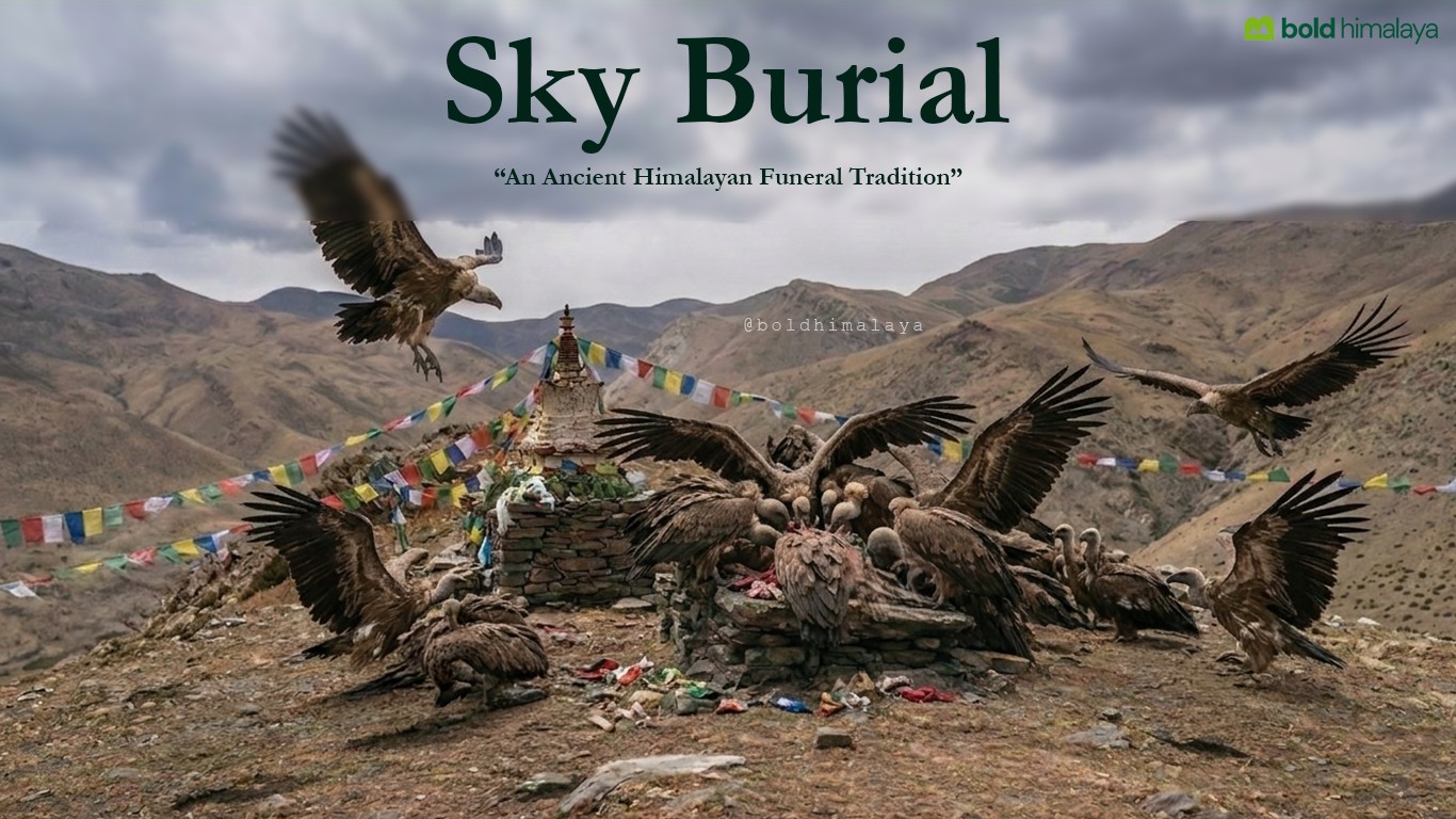

No comments yet.