


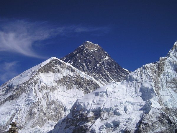
How Was Mount Everest Formed? The Tectonic Story of the World’s Highest Peak
-
 Bold Himalaya
 -
27 February, 2026
-
13 mins read
-
501 Views
-
0 Comments
Introduction
How did the world’s tallest mountain—a peak of solid rock soaring 8,848.86 meters into the sky—begin its life at the bottom of an ancient sea?
The answer lies in slow, relentless pressure. Starting around 50 million years ago, a steady squeeze built this giant as one tectonic plate met another without pause. The layers of limestone now crowning its summit began as muck on a seafloor, packed with the shells of long-dead marine creatures. Carried skyward by deep Earth motions still at work today, they mark a journey far from over. What lifted them then lifts them still.
This article explains the geological forces behind Mount Everest’s formation—from its origins in the ancient Tethys Ocean to the ongoing continental collision that continues to push it higher.
The Prehistoric Beginning: Gondwana and the Tethys Ocean
The story of Mount Everest begins not with mountains, but with an ocean.
Around 180 million years ago, Earth’s landmasses looked nothing like they do today. A supercontinent called Gondwana dominated the southern hemisphere, encompassing what would become Africa, South America, Antarctica, Australia, and India.
Then Gondwana began fracturing.
Drifting away from it came a block that would become the Indian subcontinent. Northward motion followed, driven not by chance but by mantle convection currents deep beneath Earth’s crust. In between this traveler and its northern counterpart—the massive Eurasian Plate—a wide ocean held sway. That expanse bore the name Tethys.
For roughly 130 million years, the Indian Plate drifted across this ocean. During that immense span, life thrived in Tethys’s warm, tropical waters:
- Trilobites scuttled across the seafloor
- Crinoids (sea lilies) waved in ancient currents
- Brachiopods filter-feed in shallow reefs
Their shells and skeletal debris settled slowly onto the seabed, layer upon layer. Over time, pressure fused these deposits into solid limestone. No one alive then could have imagined where those seafloors would one day rest.
The Great Himalayan Orogeny — From Ocean Floor to the World’s Highest Peak
The formation of Mount Everest is the most dramatic example of an active continental collision on Earth. Its story begins not with mountains, but with the slow northward movement of the Indian Plate and its eventual impact with the Eurasian Plate around 50–60 million years ago.
According to the American Museum of Natural History, this collision began when the Indian Plate broke away from the ancient supercontinent Gondwana and raced northward at speeds far faster than any continent moves today.
Unlike mountain ranges formed by oceanic subduction (such as the Andes), the Himalayas arose from a rare continental–continental collision. Because both the Indian and Eurasian plates are composed of thick, buoyant continental crust, neither could sink easily into the mantle. Instead, they locked together, creating a prolonged zone of intense compressional stress. The ancient seafloor of the Tethys Ocean, once composed of horizontal layers of limestone and marine sediments, was caught between them.
As convergence continued, these layers were folded, stacked, and thrust upward through a process known as crustal shortening. Rather than descending into the Earth, the crust thickened and rose, initiating the uplift of the Himalayas and setting the foundation for Everest itself.
1. Crustal Doubling — The Deep Roots of Everest
Before the collision, sediments accumulated on the floor of the ancient Tethys Ocean. When convergence began, those once-horizontal layers were folded, stacked, and thrust upward through a process known as crustal shortening.
The result was not only surface uplift but deep structural thickening.
- Extreme Thickness: Beneath Everest, the crust reaches approximately 70–72 kilometers, nearly twice the global continental average.
- Structural Support: This crustal doubling forms a massive root beneath the mountains, allowing extreme elevations to be maintained.
- Folding Under Pressure: At high temperatures and pressures, rock behaves plastically, bending into large-scale folds instead of simply fracturing.
This deep crustal root is what makes the world’s highest peak physically possible.
2. Structural Scaffolding — Major Thrust Systems
Uplift occurred in stages, controlled by large thrust fault systems that stacked crustal layers vertically.
- Main Central Thrust (MCT): Active primarily between 35 and 10 million years ago, this system transported deep, high-grade rocks southward and upward, forming the Greater Himalayas.
- Main Boundary Thrust (MBT): As compression migrated southward, this structure uplifted the Lesser Himalayas.
These thrust systems acted as large-scale structural ramps, progressively building elevation through repeated stacking of rock sheets.
3. Lateral Escape — Sideways Deformation
The collision did not produce vertical uplift alone. As the Indian Plate continues advancing northward at roughly 5 centimeters per year, crustal material is also displaced laterally.
This process, known as lateral escape, redirects deformation toward Southeast Asia. The combination of vertical thickening and horizontal extrusion makes the Himalayan region one of the most tectonically active areas on Earth.
4. The Ongoing Collision
The Himalayan orogeny is not a completed event. Satellite and GPS measurements confirm that convergence between the Indian and Eurasian plates continues today.
- Annual uplift: Everest rises by roughly 4–5 millimeters per year, though erosion offsets part of this gain.
- Persistent compression: Neither plate is subducting efficiently, so crust continues to accumulate upward.
- Isostatic response: Reduction of surface loads, including glacial retreat, may locally enhance uplift through isostatic rebound, though tectonic convergence remains the primary driver.
After nearly 50 million years, the collision remains active. The forces that raised Everest are still operating beneath it.
Mount Everest Was Once Under the Sea?
High on Mount Everest, the rock itself holds a surprising secret: the peak’s summit is composed of ancient sea life. These materials solidified over hundreds of millions of years into limestone, originating from creatures that thrived in long-vanished tropical waters.
The Qomolangma Formation
The stone at the very top of the mountain is known to geologists as the Qomolangma Formation (or Everest Limestone). This sediment settled on the floor of the ancient Tethys Ocean during the Ordovician Period (between 450 and 500 million years ago). For eons, these layers were buried, only to be “scraped” off the seafloor and thrust skyward when India collided with Eurasia.
The International Union of Geological Sciences recognizes this summit limestone as a site of global geoheritage significance, noting that it contains “abundant and diverse marine fossils” from the Middle Ordovician period
Identifiable Marine Life at 29,032 Feet
Found within stone fragments just below the summit are not just vague impressions, but actual preserved remnants of marine life:
- Trilobites: Extinct hard-shelled marine arthropods that scuttled across the seabed.
- Crinoids: Known as “sea lilies,” these animals were anchored to the seafloor by long stalks.
- Brachiopods: Shelled animals similar to modern-day clams that filtered nutrients from tropical currents.
A Journey of 8,849 Vertical Meters
The presence of these fossils is the “smoking gun” of plate tectonics. Because continental crust is relatively light and buoyant, these deposits could not sink (subduct) into the Earth’s mantle. Instead, they were forced upward.

Over millions of years, the shifting crust lifted these ancient seabed residents from the dark depths of the ocean to the thin air of the stratosphere. Their location reveals the staggering scale of Earth’s dynamic surface: what once lay beneath the ocean today stands as the highest point on Earth.
The Timeline of a Giant: When Did Everest Form?
Mount Everest did not simply appear. It is the result of a 50-million-year architectural project driven by the Earth’s mantle. While the “foundation” was laid long ago, the mountain we recognize today is, in geological terms, a relatively recent addition to the skyline.
1. The Initial Contact (50–60 Million Years Ago)
The “Great Collision” began in the Eocene Epoch. As the Indian Plate slammed into the Eurasian Plate, the Tethys Ocean closed forever. During this stage, the land began to fold and thicken, but the Himalayas were likely only a range of modest hills, nowhere near their current multi-mile heights.
2. The Miocene “Growth Spurt” (25–10 Million Years Ago)
This is the era when Everest became a giant. During the Miocene, the speed of the collision increased.
- Intense Compression: The crust was squeezed so tightly that it reached a depth of 70 kilometers.
- The High Peaks Emerge: Powerful thrust faults (the MCT and MBT) acted like giant ramps, stacking miles-thick slabs of rock on top of each other. Most scientists believe the Himalayas reached “modern” elevations (above 5,000 meters) during this window.
3. The “Everest Anomaly” (89,000 Years Ago to Present)
While tectonic plates provided the bulk of the height, a recent discovery explains why Everest is nearly 250 meters taller than other peaks in the range.
- River Piracy: Roughly 89,000 years ago, the Arun River merged with the Kosi River system. This created a massive increase in erosion, carving a deep gorge near the mountain’s base.
- Isostatic Rebound: As the river washed away billions of tons of rock and soil, the Earth’s crust “bounced” upward, much like a boat rising in water when cargo is removed. This process alone has added an estimated 15 to 50 meters to Everest’s height in just the last few millennia.
4. The Modern Growth Rate
Today, Everest continues to grow at a measurable pace.
- Tectonic Growth: ~4 mm per year (driven by the plates).
- Isostatic Growth: ~2 mm per year (driven by erosion and glacial melt).
- Net Change: Despite the wind and ice trying to wear it down, Everest is currently “winning” the battle against erosion, reaching further into the atmosphere every single day.
Geological Eras of Mount Everest
| Era | Timeframe | Major Event |
| Ordovician | 450M Years Ago | Marine limestone forms on the Tethys seafloor. |
| Eocene | 50M Years Ago | Initial collision between India and Eurasia. |
| Miocene | 20M Years Ago | Main phase of uplift; Himalayas reach extreme heights. |
| Pleistocene | 89,000 Years Ago | River capture triggers “Isostatic Rebound” growth spurt. |
| Holocene | Today | Ongoing rise of ~5mm annually. |
Mount Everest Keeps Rising?
For years, scientists attributed Everest’s height solely to tectonic plates. However, recent breakthroughs in 2024–2026 reveal a second “engine”—Isostatic Rebound—which explains why Everest is nearly 250 meters taller than its nearest neighbors.
1. The Tectonic Engine (Primary Driver)
The Indian Plate remains relentlessly active, advancing northward into the Eurasian Plate at a rate of approximately 5 centimeters per year, a rate confirmed by the American Museum of Natural History’s geological research
- The Vertical Squeeze: This persistent pressure folds the crust upward, driving the bulk of the mountain’s growth.
- The 2020 Standard: This ongoing activity necessitated the official update to 8,848.86 meters (29,031.7 feet), the current international benchmark.
2. The “Arun River” Boost (The Growth Spurt)
Research published in Nature Geoscience confirms that a unique erosion event is “lifting” the mountain from below.
- River Piracy: Roughly 89,000 years ago, the Arun River merged with the Kosi River system. This “capture” event dramatically increased the river’s ability to wash away rock.
- The Rebound Effect: As the river carved a massive gorge and removed billions of tons of debris, the Earth’s crust “bounced” upward—much like a boat rising in water after its cargo is unloaded.
- Net Impact: This process adds an extra 2 mm per year to the summit’s height, effectively doubling its growth speed in the current geological epoch.
The 2024 Height Balance Sheet
| Force | Effect on Height | Status |
| Tectonic Collision | ~1.5-1.8 mm/year | Continuous pressure |
| Isostatic Rebound | ~0.2-0.5 mm/year | Accelerating growth |
| Glacial Erosion | -2 to 3 mm/year | Wear and tear from the weather |
| Net Result | Positive Growth | Active Expansion |
3. Monitoring with Precision
Modern geologists now use GNSS (Global Navigation Satellite Systems) and ground-penetrating radar to track movement in real-time. These tools reveal that Everest is not just moving up—it is also shifting northeast.
Despite the constant grinding of the Khumbu Glacier, the “Roof of the World” is currently winning the battle against erosion. Every climber reaching the summit today stands a few millimeters higher than those who stood there just a year ago.
The Layers Beneath Mount Everest
Everest is often compared to a “giant layered cake.” From the summit to the base, the mountain is composed of three distinct geological units, each separated by massive fault lines.
1. The Qomolangma Formation (The Summit)
The “cap” of the mountain consists of pale grey limestone and dolostone. This is the Qomolangma Formation, dating back to the Ordovician Period (450–500 million years ago).
- Character: Because it has remained relatively close to the surface, it has undergone minimal metamorphism.
- The Secret: This is where you find the trilobite and crinoid fossils, as the rock was never heated enough to destroy their delicate structures.
2. The North Col Formation (The Midsection)
Beneath the summit limestone lies the North Col Formation. These are sedimentary rocks—primarily schist and marble—that have been “cooked” by heat and pressure (metamorphism).
- The Yellow Band: The most famous feature of this layer is the Yellow Band, a distinct yellowish-brown marble visible from miles away. It sits just below the summit pyramid and serves as a major landmark for climbers on the North and South faces.
3. The Rongbuk Formation (The Core)
At the base of the mountain lies the Rongbuk Formation, the “basement” of Everest. This consists of high-grade metamorphic rocks like gneiss and igneous granite.
- Origin: These rocks were once buried 25 to 30 kilometers deep. During the Miocene (20–24 million years ago), the pressure was so intense that the crust partially melted, forming the granite “veins” (leucogranites) that now lace the base of the peak.
- Journey: These rocks have traveled the furthest, rising from the crushing depths of the Earth’s interior to the surface.
The Lhotse Detachment: The Great Slide
The Lhotse Detachment separates the summit limestone from the metamorphic layers below.
- What it is: This is a “low-angle normal fault.” As the Himalayas grew too tall and heavy, the top layers literally began to slide off the back of the mountain toward the north.
- Significance: It proves that Everest’s height is a balance between tectonic forces pushing it up and gravity pulling it apart.
How the Peak Got Its Shape
While tectonics provided the height, the weather provided the “sculpture.”
- Pyramidal Form: Everest is a horn, a specific mountain shape created when multiple glaciers (the Khumbu, Rongbuk, and Kangshung) grind away at the sides of a peak from different directions.
- Frost Wedging: Because the air is so thin and cold, water enters tiny cracks in the rock, freezes, and expands. This “shatters” the stone from the inside out, creating the sharp, jagged ridges like the Southeast Ridge and the West Ridge.
Conclusion
The story of Mount Everest does not conclude with its present height. Ongoing movements beneath the surface shape it still, driven by pressures older than the peak itself—forces that persist well beyond today’s readings. While rock rises now, time ensures those numbers shift later. Change defines the structure, not stability, as deep dynamics proceed without pause. Measurements fade quickly when nature works on such scales. What stands tall today follows patterns set millions of years ago. Future forms emerge under rules unchanged since beginnings lost to record.
Earth’s outer layer moves, as Everest clearly shows. Drifting happens across continents. Seabeds rise slowly over time. Layers built underwater long ago rest almost nine thousand meters high today. These shifts take immense spans to unfold. Evidence locked in stone confirms what seems invisible otherwise.
Still adjusting, the peak reflects shifts below. Thanks to precise GPS data, elevation updates show Everest is not static. Movement continues as the Indian tectonic plate advances northward. Under pressure from within Earth, uplift persists slowly. Rising happens gradually due to ongoing crustal interaction. This growth follows patterns driven by deep planetary motion.
Comments (0)
Write a comment- Introduction
- The Prehistoric Beginning: Gondwana and the Tethys Ocean
- The Great Himalayan Orogeny — From Ocean Floor to the World’s Highest Peak
- Mount Everest Was Once Under the Sea?
- The Timeline of a Giant: When Did Everest Form?
- Mount Everest Keeps Rising?
- The Layers Beneath Mount Everest
- How the Peak Got Its Shape
- Conclusion
Read the latest Blogs & Insights
Explore our collection of articles and insights to gain in-depth travel knowledge, expert advice, and stay updated on the latest trends and tips.
View All Articles
Prayer Flags
10 Jul. 2026
Golf Tour in Nepal
30 Jun. 2026
Mera Peak vs Island Peak Climbing
12 Jun. 2026


No comments yet.