


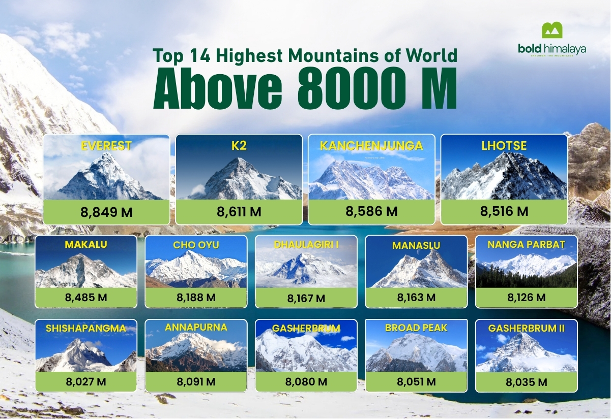
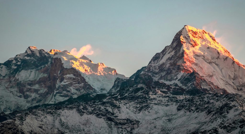
The 14 Highest Mountains in the World
-
 admin
admin -
29 October, 2024
-
36 mins read
-
3930 Views
-
0 Comments
The 14 highest mountains in the world are nature’s most sublime creations, posing challenges to climbers in terms of their size, volatile weather, and technicality. All summits above 8,000 meters (26,247 feet) are part of an exclusive list of mountains known as the Eight-Thousanders—a descriptive shorthand for the 14 above 8,000 meters. Situated in the Nepalese, Tibetan, Pakistani, and Indian Himalaya and Karakoram ranges, the summits have otherworldly allure and draw beyond which to resist.
Climbers from all over the world would fantasize about conquering these legendary giants, but defeating them requires years of physical conditioning, technical expertise, and mental endurance. This blog provides an overview of the world’s 14 mountains, including facts on their height, history, main climb routes, techniques, and conditions that adventurers have to endure in pursuing them.
Watch: A breathtaking journey over the world’s 14 highest mountains
Let us know if you are also interested in Manaslu Circuit Trek, Tsum Valley Trek, and Manaslu Base Camp Trek.
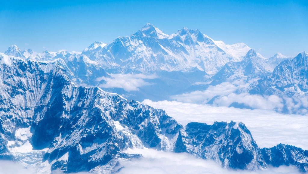
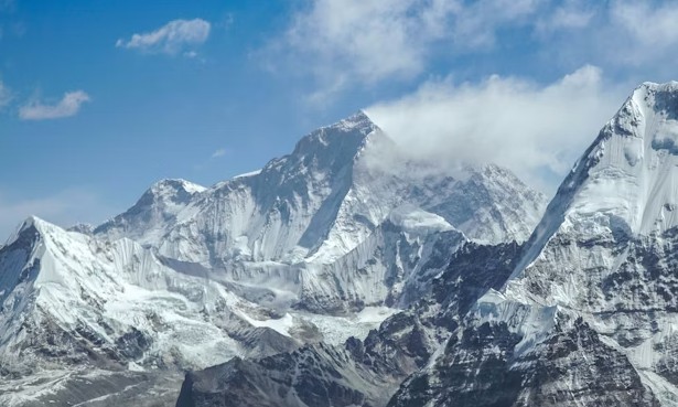
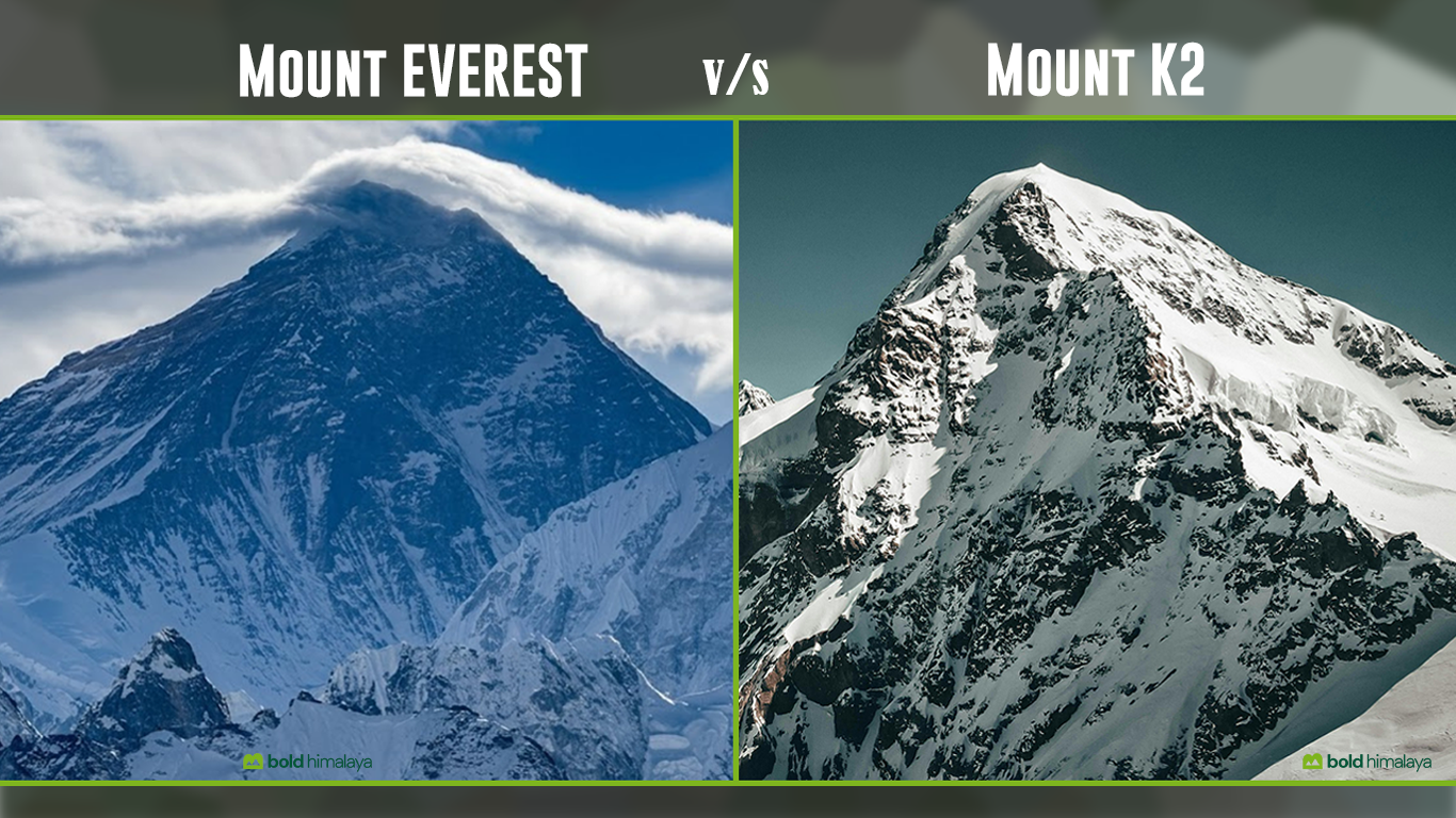
1. Mount Everest – The Mother of All Mountains
Quick Facts
- Height: 8,848.86 meters (29,031.7 feet)
- Location: Border of Nepal and Tibet (China)
- Range: Mahalangur Range of the Himalayas
- Also Known As: World’s Highest Mountain
- Type: Fold Mountain
Mount Everest is the highest mountain among all 14 highest mountains in the world, with a height of 8,848.86 meters (29,029.29 feet). A 2020 joint survey by Nepal and China officially confirmed this. As the “world’s highest mountain,” it falls in the Mahalangur Himal sub-range of the Himalayas and is jointly occupied by Tibet (China) and Nepal along their border.
Formed millions of years ago by the collision of the Indian and Eurasian tectonic plates, Mount Everest is rising slowly each year due to ongoing geological activity. The mountain is covered with many thick layers of snow and ice, and its climate is extremely tough, with strong winds and freezing temperatures throughout the year.
Names and Cultural Significance
It holds cultural importance for human beings, as evidenced by its informal names: Nepali “Sagarmatha,” meaning “Goddess of the Sky,” and Tibetan “Chomolungma,” meaning “Holy Mother.” These are the names of awe with which the inhabitants refer to this giant after millennia of existence.
Geological Formation
Everest emerged approximately 60 million years ago when the Indian and Eurasian tectonic plates collided and pushed the Earth up to form the stunning Himalayan mountain range. The actual peak is still rising about 4mm taller each year because of ongoing tectonic pressure, so the Himalayas are likely to be one of the globe’s youngest and most dynamic mountain ranges.
Historical Measurements
Everest was surveyed for the first time by the Great Trigonometrical Survey of India in 1856, which had, in turn, been named after the then Surveyor General of India, Sir George Everest. Earlier, with improvements in surveying instruments, there were several other peaks that were wrongly thought to be the highest in the world, until they measured that Everest was the highest.
The First Ascent
The ultimate victory at the peak was achieved on May 29, 1953, by New Zealand’s Sir Edmund Hillary and Nepalese Sherpa Tenzing Norgay as they summited. It was the result of a succession of unsuccessful attempts from, among others, doomed George Mallory and Andrew Irvine’s 1924 expedition, who vanished near the peak, to perpetuate perhaps mountaineering’s biggest mystery.
Primary Climbing Routes
Two main routes are taken to the summit of Everest:
- Southeast Ridge (Nepal): Climbed most frequently, originally ascended by Hillary and Tenzing in 1953. It includes the hazardous Khumbu Icefall and the mythical Hillary Step (destroyed in 2015).
- North Ridge (Tibet): A technically more demanding route with government approval from the Chinese government. Used by the earlier British expeditions, including the doomed Mallory and Irvine attempt.
The Full Expedition Experience
Everest climbing is far more than a few days of climbing. It would take the average expedition around 65 days and involve:
- Several acclimatization climbs to get the body used to high altitude
- Establishing four camps at progressively higher altitudes
- Passing through the hazardous Khumbu Icefall multiple times
- Camp life at Base Camp for periods of good weather
- Using supplemental oxygen above 8,000 meters in the “Death Zone.”
- Surviving -60°F (-51°C) and colder
Best Climbing Seasons
There are two climbing seasons in which climbers climb Everest:
- Pre-monsoon (April-May): Busiest time, more reliable weather
- Post-monsoon (September-October): Fewer climbers but a greater possibility of remaining monsoon snow
Otherwise, bone-chilling cold and severe jet stream winds make climbing an effectively impossible undertaking, especially in winter when mountain winds scorch more than 200 mph.
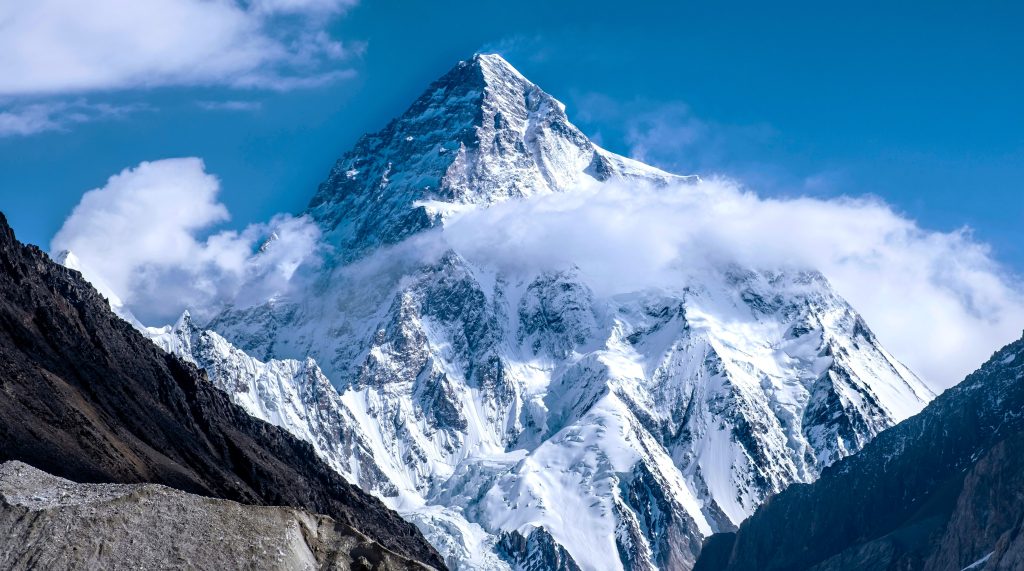
2. K2 – The Savage Mountain
Quick facts
- Height: 8,611 meters (28,251 feet)
- Location: Between Pakistan and China
- Range: Karakoram Range, Himalayas
- Also Known As: The Savage Mountain
- Type: Fold Mountain
K2 is the second-tallest mountain in the world, rising 8,611 meters (28,251 feet) above sea level. K2, which lies in the Karakoram Range near the Pakistan-China border, has been dreadfully dubbed “The Savage Mountain” because of its extremely challenging and lethal climb.
The weather is extremely harsh and unstable, with strong winds, heavy snowfall, and freezing temperatures. Unlike Mount Everest, which thousands have climbed, far fewer have reached K2’s summit, and many have lost their lives attempting it.
Name Origin
In contrast to most romantically or traditionally named tallest mountains, K2 merely owes its name to the convention of surveyors. Named by British surveyor Thomas Montgomerie in 1856 (the second Karakoram peak that he was surveying), despite all subsequent efforts to give it more official names like Mount Godwin-Austen, the simple “K2” has remained, perhaps appropriately for a mountain renowned for raw brutality.
First Successful Ascent
The peak was not reached until July 31, 1954, when Lino Lacedelli and Achille Compagnoni were left on the peak by Ardito Desio’s Italian team. That was a long time after the first Everest ascent, which K2 followed with harder obstacles. They did so in particular without the use of Sherpas, as in the typical Everest climbing attempts.
Factors for Climbing Difficulty
The negative reputation of K2 stems from a combination of technical difficulties:
- Ice walls are near vertical, with advanced technical climbing
- The infamous “Bottleneck” – a steep couloir under unstable ice seracs
- Steeper overall slopes than Everest (average 45 degrees)
- More technical rock climbing at fixed extreme altitudes
- Unreliable weather with ferocious, sudden storms
- More isolation with more complicated rescue potential
Major Climbing Routes
- Abruzzi Spur (Southeast Ridge): Most popular route, with technical ice climbing and steep rock pitches
- Cesen Route (South-Southeast Ridge): An alternate route that avoids some dangers of the Abruzzi Spur but provides others
- North Ridge: Infrequently attempted due to the Chinese side’s inaccessibility and its incredibly radical technical challenges
- West Face: Perhaps the most difficult route, climbed only a handful of times to the summit
Notable Disasters
K2’s fatal image is underscored by major catastrophes:
- 1986 K2 Disaster: Five fatalities in one day, including celebrated British climber Alan Rouse.
- 2008 K2 Tragedy: Eleven lives were lost when a serac of ice gave way in the Bottleneck, one of the saddest days in recent climbing history
- Winter Attempts: For many decades, the only 8000m peak to be left unscaled in winter was K2, and it was at the cost of several lives until, in January 2021, a Nepali team achieved success.
Climbing Season
The optimal time for climbing K2 is quite limited – typically just a few weeks in July and August. Climbing during winter was believed to be impossible until the record first winter ascent in 2021. The site and geography of the mountain impose especially extreme weather conditions, including temperatures of below -65°F (-54°C) and hurricane-force winds being the norm.
Why is K2 Known as The Savage Mountain?
K2 is known for having both an extremely dead reputation and climbing difficulty. Unlike Everest, K2, the tallest mountain, is steeper, colder, and more technically demanding. The routes are exposed to the risk of being hit by a large mass of ice, rockfalls, and fierce storms that can last for days. It’s guessed that for every four climbers who reach the summit, one dies, which makes it one of the most dangerous peaks on Earth. It’s because the fatality rate, which is called “The Savage Mountain that tries to kill you.”
3. Mount Kanchenjunga – The Five Treasures of Snow

Quick Facts
- Height: 8,586 m (28,169 ft)
- Location: Border of Nepal and Sikkim, India
- Range: Eastern Himalayas
- Also Known As: “The Five Treasures of Snow”
- Type: Fold Mountain
Kanchenjunga is a Himalayan peak that stands at 8,586 meters (28,169 feet) tall, and is also the third-highest mountain among the 14 highest mountains in the world. On the Nepal-India border, it is named in Tibetan “Five Treasures of Snow” because it has five huge peaks.
Kanchenjunga is known for its breathtaking beauty and spiritual significance. People of Sikkim and the eastern region of Nepal believe that it is a sacred mountain, often associated with local spirits and legends. Due to this respect, early climbers stopped short of reaching the exact summit out of reverence for its divinity.
The Five Peaks
Far from being one peak, Kangchenjunga is a gigantic mountain range with:
- Kanchenjunga Main (8,586m/28,169ft)
- Kanchenjunga West (8,505m/27,904ft)
- Kanchenjunga Central (8,482m/27,828ft)
- Kanchenjunga South (8,494m/27,867ft)
- Kanbachen (7,903m/25,928ft)
Three of them: Main, Central, and South, occupy the physical Nepal-Sikkim border, and West and Kangbachen are located in Nepal. They surround the extensive Kangchenjunga Glacier in a horseshoe-shaped ridge.
Spiritual Significance
Kanchenjunga also possesses profound religious meaning to its inhabitants. The Limbu, Kirat, and Lepcha people believe that it is the dwelling place of their god Yuma Sammang. This religious meaning is the reason for a unique mountaineering practice: climbers don’t climb to the actual summit as a mark of respect for indigenous tradition. This was started by the first climbers on the mountain in 1955 by British climbers Joe Brown and George Band, and is followed by thoughtful climbers today.
Historical Measurements
Before more accurate measurements in the 1850s, Kangchenjunga was known as the highest mountain summit on the planet. The area had been investigated by a British expedition Joseph Dalton Hooker in 1848, not only measuring the summit but also measuring the highly diversified ecological gradient from subtropical to alpine.
Conservation Significance
One of the Himalayas’ most biologically diverse areas is the Kangchenjunga region. Since its creation in 1997, the Kanchenjunga Conservation Area has safeguarded more than 2,000 square kilometers of habitat for endangered species, such as:
- Snow leopards
- Red pandas
- Himalayan black bears
- Musk deer
- Over 250 bird species
- Nearly 40 rhododendron species
Climate change is the main hazard to this delicate ecosystem, with glacial retreat accelerating over the past few decades.
Climbing Challenges
Kanchenjunga offers extreme mountaineering conditions:
- Remote route with long treks through dense jungles
- Unpredictable weather with sudden, violent storms
- Avalanche extremes on all four routes
- Technical ice climbing routes
- More vertical exposure from base camp to the summit than on Everest
Major Climbing Routes
- Southwest Face (Nepal): Most ascended and standard route, with challenging technical ice climbing and severe avalanche hazard
- Northeast Spur (India): Fewer ascended because of the Indian government restrictions and technical difficulties
Why visit Mount Kanchenjunga?
Exploring Mount Kanchenjunga offers a trekking experience through remote trails, rhododendron forests, glacial valleys, and authentic mountain villages. The Kanchenjunga Conservation Area in Nepal protects rare wildlife like the snow leopard, red panda, and Himalayan black bears. Trekkers are rewarded with majestic viewpoints of the Five Treasures of Snow and an unmatched sense of peace and adventure.
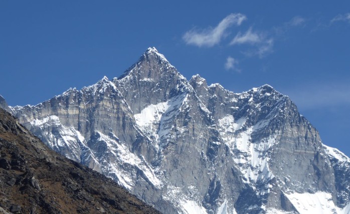
4. Mount Lhotse – The Sister Peak of Everest
Quick facts
- Height: 8,516 meters (27,940 feet)
- Location: Border of Nepal and Tibet (China)
- Range: Mahalangur Range, Himalayas (same range as Mount Everest)
- Also Known As: Fourth-highest mountain in the world
- Type: Fold Mountain
Lhotse stands at 8,516 meters (27,940 feet) and is the world’s fourth-highest mountain. The “South Peak” is a fitting name, with its position being directly associated with Mount Everest via the South Col. It is here that geographically and climber-culturally it is considered Everest’s sister peak.
Three-Peaked Massif
Lhotse is a three-peaked massif and comprises the following:
- Lhotse Main (8,516m/27,940ft)
- Lhotse Middle (8,414m/27,605ft)
- Lhotse Shar (8,383m/27,503ft)
Lhotse Middle remained unclimbed until 2001, when it was one of the last of the great Himalayan tasks to give way. Between those two mountains is one of the highest and most dramatic ridges on the planet.
The Lhotse Face
The most sensational feature of the mountain is the intimidating Lhotse Face – a 1,125-meter (3,700-foot) ice face up to 60 degrees in pitch. The intimidating wall is one of the acclimatization hurdles for climbers of the Everest and Lhotse summits. Climbing requires sophisticated ice climbing skills, such as front-pointing with crampons and ice axe usage for long hours at high altitude.
First Ascent
Lhotse was first ascended on May 18, 1956, by Swiss climbers Ernst Reiss and Fritz Luchsinger, as part of a large expedition. The accomplishment had been only three years after Everest’s first ascent, but Lhotse has made significantly fewer total successful climbs.
The South Face Challenge
Lhotse’s finest feature is probably its South Face – a gargantuan 3,300-meter (10,800-foot) wall that is one of the world’s largest mountain faces. Climbers waited until 1990 to try this behemoth of a wall, when Soviet pair Sergei Bershov and Vladimir Karataev completed what has been universally accepted as one of the greatest high-altitude climbs ever made.
Climbing Route
Lhotse and Everest share a lot of the same climbing route:
- Climbers start at Everest Base Camp
- They cross the Khumbu Icefall
- They climb the Western Cwm (the “Valley of Silence”)
- Lhotse climbers branch off at Camp 3 on a different route from Everest
- They initially ascend the tricky Lhotse Couloir, an ice and rock gully at a high angle and narrow
- The final section is technical mixed climbing at very, very high altitude
This collaboration has enabled the “Everest-Lhotse Link-up” – climbing both mountains in one push, an achievement for very few of the best climbers.
5. Mount Makalu – The Isolated Pyramid of the Himalayas
Quick Facts
- Height: 8,485 meters (27,838 feet)
- Location: Border of Nepal and Tibet (China)
- Range: Mahalangur Range, Himalayas (southeast of Mount Everest)
- Also Known As: 5th-highest mountain in the world
- Type: Fold Mountain
8,485 meters (27,838 feet) tall, Makalu is the fifth-tallest mountain in the world. A mere 22 kilometers (14 miles) east of Everest in the Mahalangur Himalayas, it stands singularly with its perfect pyramid shape composed of four knife-edged ridges.
Name Origin
The name was derived from the Sanskrit “Maha Kala,” itself a title of the Hindu deity Shiva as time and destroyer. This was both a reference to the ominous presence of the mountain and the religious connotation to Aboriginal people who reverence the summit.
Isolated Position
In contrast to other summits surrounding it that are part of linked ridges, Makalu is completely isolated. This renders the summit very dramatic in appearance, but at the same time, more susceptible to harsh weather. Without connecting ridges to deflect the wind, Makalu is battered by some of the Himalayas’ strongest sustained winds.
First Ascent
Makalu’s first climb on May 15, 1955, by a French expedition led by Jean Franco, did something new in the history of Himalayan climbing. Ten members of the expedition climbed to the top in three days’ waves – from Neil Armstrong to wannabe climbers – nothing unusual in an age when team climbs were unheard of. The leaders at the top were Lionel Terray and Jean Couzy.
Technical Difficulty
It’s what makes Makalu stand apart from nearly every other 8,000-meter peak, except the very few: its uniform technical difficulty. While some of the high peaks present individual challenging sectors, Makalu presents technical obstacles to climbers at the base and through the summit:
- Knife-edge ridges, where balance needs to be painstakingly maintained
- Near-vertical ice walls require high-level climbing skills
- Mixed climbing pitches on rock and ice
- All of these are at extreme altitudes with oxygen levels dangerously low
The Makalu Couloir
Reaching the Makalu La (pass) at 7,400 meters, climbers are confronted with the technical crux of the climb – the Makalu Couloir. A steep, thin ice gully to the summit ridge demands precise ice climbing technique in conditions of altitude hardship and exposed risk. The majority of climbers head back here, even after they have traversed the pass.
West Face Challenge
The West Face of Makalu is perhaps the toughest Himalayan mountaineering challenge. The 2,000-meter (6,600-foot) ice and rock face was first climbed as late as 1997 when a Russian expedition established a new route after several attempts. Very few individuals have climbed it, and it remains one of the highest altitude mountaineering feats.
Makalu-Barun Valley
Makalu is accessed through the Makalu-Barun Valley, which is the remotest and most ecologically diverse valley in Nepal. Makalu-Barun National Park, established in 1992, encloses the valley and features a diverse array of ecosystems from tropical forest at lower elevations to the alpine zone at the base of the mountain. It is a highly remote valley and far less settled than much of the other trekking country of Nepal.
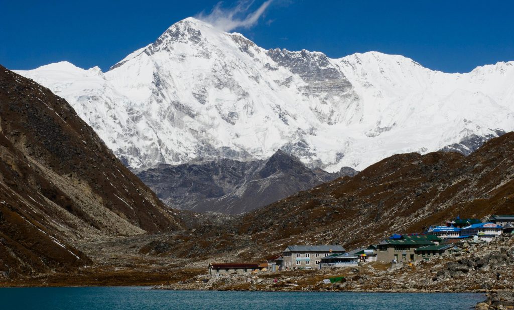
6. Mount Cho Oyu – The Turquoise Goddess
Quick Facts
- Height: 8,188 meters (26,864 feet)
- Location: Border of Nepal and Tibet (China)
- Range: Mahalangur Range, part of the Himalayas
- Also Known As: 6th-highest mountain in the world
- Type: Fold Mountain
Among the 14 highest mountains in the world, Cho Oyu is the sixth-highest peak at 8,188 meters (26,864 feet). Just 20 kilometers from Everest on the Tibet-Nepal border, this giant has also been described as “The Easiest Eight-Thousander” due to its fairly uncomplicated standard route.
Name and Cultural Significance
Its Tibetan title, “Cho Oyu,” refers to “Turquoise Goddess” due to the blue-green color this mountain exhibits from time to time when it shows a specific type of light. It is also a sacred peak to indigenous Tibetans as it is part of the greater spiritual complex above adjacent peaks such as Everest and Shishapangma.
Accessibility Factor
Cho Oyu’s relatively straightforward slopes and absence of technical challenges on its normal route have also rendered it a climber’s favorite among those who want to climb extreme altitude without the additional frustration of mountains such as K2 or Makalu. The Northwest Ridge route contains little to no extremely technical ground, and therefore is an excellent proving ground for climbers who want to proceed to more challenging 8,000-meter peaks.
First Ascent
The Austrian expedition first ascended Cho Oyu on October 19, 1954. Herbert Tichy, Joseph Jöchler, and Sherpa Pasang Dawa Lama ascended to the top utilizing a newfangled technique for the time – alpine-style climbing with no fixed camps and without supplementary oxygen. The light-style climb was progressive for 8,000-meter peaks.
Nangpa La Connection
The proximity of the mountain to the Nangpa La pass (5,800m/19,000ft) gives it another cultural aspect. The pass has been used for over 800 years as the main trade route between Tibet and Nepal, and Tibetan traders and yak treks still cross from time to time, close to climbing expeditions. It gives climbing Cho Oyu a ghostly ambiance that is not present on most of the other great mountains.
Climbing Routes
- Northwest Ridge Route (Tibet): Easiest and most frequented route, moderate angles, and little tech climbing
- Southwest Face Route (Nepal): Much more difficult technical climb rarely attempted
Commercial Expeditions
Cho Oyu has been increasingly pursued in recent years as a commercial ascent, and there are now a number of companies that provide guided ascents. The mountain also has more successful ascents than most of the other 8,000-meter peaks, and it is beloved by trekkers wishing to attempt all fourteen of the 8,000-meter peaks. That being said, its accessibility is not to be confused with safety – altitude sickness is still the danger of potentially fatal pulmonary and cerebral edema.
7. Mount Dhaulagiri I – The White Mountain of Nepal
Quick Facts
- Height: 8,167 meters (26,795 feet)
- Location: Nepal, in the Dhaulagiri Range of the Himalayas
- Range: Dhaulagiri Himal, part of the Western Himalayas
- Also Known As: 7th-highest mountain in the world
- Type: Fold Mountain
At 8,167 meters (26,795 feet), Dhaulagiri I is the planet’s seventh-tallest mountain. Named by its locals as the “White Mountain,” in a proper nod to the year-round snow-topped ridges. Unlike many Himalayan giants in bigger ranges, Dhaulagiri is the lone summit of its range of mountains, standing in breathtaking isolation in western Nepal.
Dramatic Relief
Most striking about Dhaulagiri is that it boasts a vast vertical relief. The south face of the mountain rises almost 7,000 meters (23,000 feet) above the Kali Gandaki Gorge in a span of only 30 kilometers. This is probably the most vertical ascent of any mountain on the planet, and the visual impact is tremendous when the mountain is viewed from the bottom of the valley.
The Kali Gandaki Connection
Dhaulagiri’s reverse location to the Annapurna range, with Kali Gandaki Gorge (the world’s deepest gorge) in between them, is a geographical peculiarity to be seen nowhere else in the Himalayas. The gorge also creates a massive wind tunnel, which churns out some of the most potent valley winds in the world that reach speeds of 80 mph at times, even at comparatively lower altitudes.
Historical Significance
Dhaulagiri was the world’s tallest peak when measured for the first time in 1808. It retained this status until Kangchenjunga was found to be taller in 1838, illustrating how Himalayan cartography developed over the years as techniques for measuring improved.
First Ascent
Unclimbed following several attempts in the 1950s, Dhaulagiri was finally achieved on May 13, 1960, when a Swiss-Austrian expedition under Max Eiselin put Kurt Diemberger, Peter Diener, Ernst Forrer, Albin Schelbert, and Sherpas Nawang Dorje and Nyima Dorje at the summit. The team employed a small aircraft (which the team jokingly called the “Yeti”) to transport supplies to higher camps, an unorthodox strategy that ceased when the plane was destroyed (although no one was killed).
The Deadly Northeast Ridge
The standard Northeast Ridge route is to climb the infamous “Dhaulagiri Icefall,” a labyrinthine mass of gigantic crevasses and fragile ice ridges that has killed more than one climber in the past. After the icefall, climbers must deal with a long, exposed ridge with technical climbing sections at extremely high altitude. Dhaulagiri is far more hazardous than its neighbor, Annapurna, because of the combination of technical difficulty and objective hazard.
Avalanche Hazard of Dhaulagiri
Dhaulagiri is just as famous for its hellish avalanche hazard, particularly on the North Face. The steep angle of the mountain walls and massive snowfall conditions are ideal for colossal avalanches. Several horrifying catastrophes have been initiated by such slides, such as the 1969 tragedy where seven men perished, and others, more recent, that still speak to the danger of the mountain.
The Seven Peaks
The Dhaulagiri massif contains seven peaks over 7,500 meters:
- Dhaulagiri I (8,167m/26,795ft)
- Dhaulagiri II (7,751m/25,430ft)
- Dhaulagiri III (7,715m/25,312ft)
- Dhaulagiri IV (7,661m/25,135ft)
- Dhaulagiri V (7,618m/25,000ft)
- Churen Himal East (7,371m/24,183ft)
- Churen Himal West (7,371m/24,183ft)
8. Mount Manaslu – The Mountain of the Spirit
Quick Facts
- Height: 8,163 meters (26,781 feet)
- Location: Gorkha District, Nepal
- Range: Mansiri Himal, part of the Nepalese Himalayas
- Also Known As: 8th-highest mountain in the world
- Type: Fold Mountain
Manaslu measures 8,163 meters (26,781 ft) in height, making it the globe’s 8th-tallest mountain. Manaslu is located in the Nepal Mansiri Himal and is as sparsely populated as Everest but just as lovely, with the same kind of technical climbs to the summit.
Name and Cultural Significance
The “Manaslu” is a nickname borrowed from the Sanskrit appellation “Manasa,” or “Spirit Mountain.” It is, in fact, Nepal’s highest mountain in Gorkha province and traditionally ascended as a preparation for future Everest ascents.
First Ascent
Manaslu was ascended on May 9, 1956, for the first time by a Japanese expedition. The first ascensionists of the summit were Toshio Imanishi and Sherpa Gyalzen Norbu, with Japan launching an extended affair with the peak. The Japanese expeditions since then have had a special place for Manaslu, engaging themselves in undertaking the majority of local development works around the area as sponsors.
Climbing Routes
- Northeast Face Route: Most frequented and most traditional climbing route, with effortless ascent compared.
- South Face Route: Technically challenging and little-tried route, only suited for the very best mountaineers.
Risk of Avalanche
Though an Everest practice peak, Manaslu is also home to the risk of avalanches. Humongous snowfall along the slope of the mountain generates risky terrain, especially on the Northeast Face, where most climbers gain entry.
Logistics of the Expedition
The classic Manaslu Climbing ascent is 45-50 days long, during which the mountaineers have time to acclimatize themselves to the higher altitude step by step. Climbing is best in spring (April-May) and autumn (September-October) when climatic conditions are best, and the risk of avalanches is comparatively minimal.
9. Mount Nanga Parbat – The Killer Mountain
Quick Facts
- Height: 8,126 meters (26,660 feet)
- Location: Gilgit-Baltistan, Pakistan
- Range: Himalayas, the westernmost part of the Himalayas
- Also Known As: 9th-highest mountain in the world
- Type: Fold Mountain
Nanga Parbat stands at 8,126 meters (26,660 feet) and ranks as the 9th-highest mountain in the world. It is ranked worse than average in conditions and is nicknamed the “Killer Mountain.”
Dramatic Relief
Nanga Parbat has the Rupal Face, the world’s highest mountain face, over 4,600 meters (15,000 feet) of vertical drop from base to summit. One of alpinism’s most stunning vistas is provided by the rock face, which shows its almost vertical relief miles away.
Geographical Significance
Being the westernmost 8,000-meter-high summit, Nanga Parbat lies on the extreme western end of the Himalayas. Isolated in the province of Gilgit-Baltistan in Pakistan, the mountain grew increasingly tough and legendary for the mountaineers.
Legendary First Ascent
Hermann Buhl’s solo ascent of Nanga Parbat in 1953 is mountaineering’s greatest achievement. On 3 July, after his friends’ withdrawal, Buhl soloed to the top without oxygen. After having spent a night exposed, standing in a bivouacked stance on a narrow ledge descending, he emerged alive, demonstrating an ability graded as superhuman.
Climbing Routes
- Rupal Face Route: The standard route follows the world’s highest mountain face.
- Diamir Face Route: A relatively less difficult but still technically demanding climb.
The Death Zone
The extreme weather of Nanga Parbat, where day after day storms form, and temperatures reach -40°C, is particularly fatal. The mountain has taken many lives, and the immense death toll makes it among the highest of the 8,000-meter mountains.
10. Mount Annapurna I – The World’s Deadliest Mountain
Quick Facts
- Height: 8,091 meters (26,545 feet)
- Location: Gandaki Province, Nepal
- Range: Annapurna Massif, part of the Himalayas
- Also Known As: 10th-highest mountain in the world
- Type: Fold Mountain
It stands at 8,091 meters (26,545 feet) tall, making Annapurna I the tenth tallest mountain in the world, but it has the highest fatality-to-summit ratio of any of the 8,000-meter giants.
Name and Cultural Significance
The name “Annapurna” is derived from a Sanskrit name and translates to “Goddess of the Harvests.” The summit is a religious local god in Hindu theology as a symbol for the goddess who nourishes and provides. Its sanctity is opposed to its notorious killer reputation among mountaineers.
Historical Milestone
Annapurna I was the pioneering 8,000-meter peak climbed in mountaineering history. French ascensionists Maurice Herzog and Louis Lachenal of a French team first stepped onto it on June 3, 1950, three years before the climb on Everest. Maurice Herzog’s narration of the ascent in his book “Annapurna” has been widely read, more than any mountaineering book published so far.
The Deadly Statistics
With a mortality rate of more than 30%, Annapurna I is the world’s most perilous 8,000-meter peak today. On climb attempts to its summit, for every three successful summiteers, one dies. Its face, exposed to repeated avalanches and unpredictable weather patterns, forms a maelstrom of risk.
Climbing Routes
- North Face Route: Most popular route, but still acutely perilous.
- South Face Route: The technically most demanding climb in the world, first done by British climber Chris Bonington’s expedition in 1970.
Avalanche Terrain
Annapurna’s steep mountain and anomalous weather patterns are the perfect place in which to witness giant avalanches. The mountain’s structure is a snow trap, piling massive amounts of snow that will suddenly let go.
11. Mount Gasherbrum I – The Hidden Peak of Karakoram
Quick Facts
- Height: 8,080 meters (26,509 feet)
- Location: Border of Gilgit-Baltistan, Pakistan, and Xinjiang, China
- Range: Karakoram
- Also Known As: 11th-highest mountain in the world
- Type: Eight-thousander (Glaciated peak in the Karakoram range)
Gasherbrum I is 8,080 meters (26,509 feet) high in the isolated Karakoram range between Pakistan and China. Its secondary atmospheric designation “Hidden Peak” is because it is located in a hidden location, which, though enormous, cannot be viewed as one gets closer. from most directions. The grandeur of the life of the mountain cannot be experienced until one is above it, so that it exudes an aura of mystery for centuries to motivate climbers.
Name Origin
The Balti name of the mountain is “Gasherbrum,” and it means “Beautiful Mountain” or “Shining Wall,” the massive shining face which catches the sun. It looks best at sunrise and sunset when the gargantuan mountain walls glint golden and reddish.
Remote Location
Gasherbrum I’s remote location is one of the reasons it is among the world’s least visited 8,000-meter peaks. The treacherous journey on the Baltoro Glacier just to reach base camp takes the climbers a scary week, crossing intricate ice structures, dangerous crevasses, and adverse weather.
First Ascent
The first ascent on July 5, 1958, was done by American Pete Schoening and Andy Kauffman, of an American party led by Commander Nicholas Clinch. Their success was the very first US ascension of an 8,000-meter summit, a breathtaking accomplishment in the annals of US mountaineering. Schoening was a legend for his “miracle belay” on K2 in 1953 when he rescued six climbers single-handedly from virtual death, and he solidified himself as legendary with this first ascent of Gasherbrum I.
Climbing Routes
- Northwest Ridge Route: The most traveled and most direct climb route, most direct to the top.
- Southwest Face Route: An extremely technical and not often attempted route reserved for the top climbers with higher skills of mixed climbing and ice.
The Gasherbrum Connection
Gasherbrum I’s proximity to Gasherbrum II (Earth’s 13th tallest peak) tempts some adrenaline-craving mountaineers to attempt ascending both mountains in a single expedition—a journey commonly called the “Gasherbrum Double.”
12. Mount Broad Peak – The Massive Summit of Karakoram
Quick Facts
- Height: 8,051 meters (26,414 feet)
- Location: Gilgit-Baltistan, Pakistan (Karakoram Range, near the border with China)
- Range: Karakoram
- Also Known As: 12th-highest mountain in the world
- Type: Non-volcanic, snow/rock mountain
The world’s twelfth-highest mountain, standing at a height of 8,051 meters (26,414 feet), Broad Peak looms high above the Karakoram mountain range on the Pakistan-China frontier. The name of the peak was bestowed due to the fantastically broad top ridge of over 1.5 kilometers in width—a characteristic bequeathed upon an 8,000-meter peak that is rare. The wide summit plateau has been a blessing and a curse for mountaineers over the years in the sense that it offers more space at the top, but also makes it unclear what exactly the highest point.
The Broad Summit
Unlike the usual 8,000-meter giant with a solitary pointed summit, the summit plateau of Broad Peak runs for over a mile, offering a different challenge to mountaineers on the final push to the top. This anomalous feature has been the cause of numerous controversies in the past, as numerous expeditions have descended, thinking that they had reached the true summit, only to later understand that the highest point was still a long way away along the ridge.
K2’s Neighbor
Just 8 kilometers from K2, Broad Peak is commonly utilized as an acclimatization ascent for climbers going for the world’s second-highest mountain. It is this closeness that has resulted in Broad Peak being referred to as “K2’s Bride” by a few of the local porters.
Historic First Ascent
The first ascent was a historic one, made by Austrian Fritz Wintersteller, Marcus Schmuck, Hermann Buhl, and Kurt Diemberger on 9 June 1957. They accomplished it in true alpine style with no supplemental oxygen and high-altitude porters, a feat at the time equivalent to siege-style attempts of 8,000-meter peaks
Climbing Routes
- West Ridge Route: The most popular route for most commercial expeditions with a relatively straightforward means but still requires good technical climbing skill and higher-order physical conditioning.
- North Face Route: A technical and steeper climb that isn’t usually pushed by commercial parties.
The Three Summits
Broad Peak itself has three summits: the main summit (8,051m), the middle summit (8,011m), and the north summit (7,490m). The three-summit geography adds a further challenge to climbers, with numerous expeditions mistakenly climbing to the fore summit only to find that they must traverse a thin ridge to reach the summit. This division has been the cause of many controversies in the history of mountaineering, with some climbers falsely claiming successful ascents when they were unable to reach the true summit.
13. Mount Gasherbrum II – The Shining Wall of Karakoram
Quick Facts
- Height: 8,035 meters (26,362 feet)
- Location: Border of Pakistan and China, in the Karakoram range
- Range: Karakoram
- Also Known As: 13th-highest mountain in the world
- Type: Snow/ice peak
Gasherbrum II stands at 8,035 meters (26,362 feet) on the Karakoram range that lies between China and Pakistan. It is also referred to as the simplest of the Karakoram 8,000-meter peaks since climbing it is quite straightforward. The triangular tip’s pyramid-shaped summit and the white, snowy ridges covered with glistening snow offer a unique sight from the giants’ party of the Gasherbrum massif.
Beginner’s 8,000er
Gasherbrum II is also gaining popularity as a safe “first 8,000-meter peak” for serious mountaineers to experience their first high-altitude extreme mountaineering adventure. Its standard route does not have the super-technical nature of neighboring summits such as K2 or Gasherbrum I, but it remains a viable choice for those with great mountaineering abilities but not much experience above 7,000 meters.
The Karakoram Connection
One of the Gasherbrum Massif, Gasherbrum II, is also near its twin, Gasherbrum I, and thus it is feasible for seasoned climbers to experience the excitement of climbing both the summits as a single expedition. The difference in the two summits, a reasonably straightforward peak, an extremely technical peak, presents a great challenge for top climbers who want to show themselves capable of being technically sound and steadfast. The same route and shared base camp make the double climb administratively possible, but perhaps not easier to plan and organize.
First Ascent
The first climb was accomplished on July 7, 1956, by Austrians Fritz Moravec, Josef Larch, and Hans Willenpart. They forged the route widely used today, demonstrating good judgment and fine proficiency in the intricately country terrain of the peak. The Austrian win was done during the heyday of Himalayan climbing when the world’s highest peaks were first being climbed.
Climbing Routes
- Southwest Ridge Route: The most traveled route, with the minimum technical challenge of the accepted routes to the top.
- West Face Route: A more difficult but less-used route with uninterrupted steep climbing on mixed ice and rock.
Expedition Logistics
Though Gasherbrum II is ranked one of the “easier” of the 8,000-meter mountains, it still consumes an enormous amount of expedition energy. The mountain is climbed in about 45-50 days, and some acclimatizing is required, along with placing high camps that consume several weeks. That it is so remote in the Karakoram creates long and difficult approaches with a several-day trek up the Baltoro Glacier just to access base camp.
14. Mount Shishapangma – Tibet’s Lonely Giant
Quick Facts
- Height: 8,027 meters (26,335 feet)
- Location: Tibet Autonomous Region, China
- Range: Himalayas
- Also Known As: 14th-highest mountain in the world
- Type: Snow/ice-covered massif, considered a trekking/expedition peak
Measuring 8,027 meters (26,335 feet), the fourteenth-highest and lowest of the 8,000-meterers in the world, Shishapangma is a curiosity on the mountaineering list and presents an unusual combination of obstacles to trekkers eager to tick off the quartet of all fourteen 8,000-meter peaks. Isolated some miles from the rest of the main Himalayan range, Shishapangma stands on its own with its own independent personality, separate from its more illustrious relatives.
The Last Conquest
Shishapangma, the last of the fourteen 8,000-meter peaks, was not climbed for technical challenge but because political considerations made it inaccessible to Western climbers for decades. The Chinese ruling Tibet allowed foreign expeditions access only sporadically until the 1970s, so that this highly accessible peak remained unclimbed until 1964, years after much more difficult mountains had been overcome.
Tibetan Isolation
As the only pure Tibetan 8,000-meter peak, Shishapangma is one of the least-accessed giant peaks due to access restrictions and permit arrangements in place. Its locally known name literally translates to “Crest Above the Grassy Plains,” and that is precisely what it rests upon – the huge Tibetan plain.
First Ascent
A Chinese expedition, under Xu Jing, arrived there on 2 May 1964. It was the culmination of all human summits of the fourteen 8,000-meter peaks that had been started with Annapurna I in 1950. The success of the Chinese expedition came at a time when China was isolated from Western mountaineering achievement and thus was even more dramatic.
Climbing Routes
- Northwest Ridge Route: The most traditional and safest route of climb, which has a relatively easy path for experienced high-altitude climbers.
- South Face Route: Much more technical and tougher climb, first done by British climbing legend Doug Scott in 1982. Steep mixed and ice terrain with massive exposure and objective hazard. Only the most skilled high-altitude climbers even consider this challenging option.
The Fourteener’s Finale
For elite climbers trying to climb all fourteen of the 8,000-meter peaks, a challenge accomplished by fewer than 50 climbers in history, Shishapangma is usually the first or last peak on their list. Its relatively smaller degree of technicality renders it an excellent starting point for climbers ascending the summit for their inaugural experience, and its political access restriction at times forces actors to ascend it last after ascending the other thirteen summits.
Significance of the 14 Peaks
Why are these 14 mountains so special?
- The only 8,000m Peaks on Earth: They are the only mountains on the globe with heights above 8,000 meters.
- Tough Beyond Imagination Environments: They are cold, they have avalanches, and awfully thin air.
- They’re in the Himalayas & Karakoram: They stretch along Nepal, Pakistan, and Tibet, the highest place on the globe.
- Enduring Test of Endurance: To ascend, one even takes months of conditioning, mental sharpness, and technical skill.
Notable Climbers and Records
Some record-breaking climbers on these mountains include:
- Reinhold Messner (Italy): First to climb all 14 peaks without using oxygen (1970–1986).
- Jerzy Kukuczka (Poland): Second to climb all 14 peaks, via more difficult routes (1979–1987).
- Nirmal Purja (Nepal): Fastest to climb all 14 peaks in just 6 months and 6 days (2019).
- Kristin Harila & Tenjin Sherpa (Norway/Nepal): Fastest without oxygen (92 days in 2023).
- Tenzing Norgay & Edmund Hillary: First to reach the summit of Mount Everest (1953).
Challenges of Climbing the 14 Highest Mountains
These peaks are not a question of raw strength—it’s a battle against nature, thin air, and harsh conditions:
- Extreme Cold:-50°C (-58°F) yields a life-threatening hazard of frostbite.
- Thin Air: Higher than 8,000 meters above, it is almost impossible to breathe.
- Avalanches & Crevasses: The easily dislodged snow and ice render peaks such as Annapurna and Dhaulagiri quite hazardous.
- Technical Climbing: K2 and Kangchenjunga are climbed with technique in order to climb ice walls and vertical rock walls.
- Expensive & Complicated Planning: Each climb takes thousands of dollars and months of planning.
How to Prepare for an 8,000m Peak
If climbing one of these giants is your agenda, this is what climbers do in preparation:
- Build Physiological Endurance: Long treks, high-altitude acclimatization, and strength training.
- Accumulate Lower Peak Experience: Start with 5,000-6,000m peaks and then climb an 8,000m peak.
- Gear Up Appropriately: Oxygen bottles, warm outerwear, crampons, ice axes, and ropes are employed.
- Acclimatization & Safety: Stay weeks at base camps, sequentially moving higher to acclimatize to the thin air.
- Embark on a Professional Journey: Guides, Sherpas, and a support team are needed for safety.
FAQs About the 14 Highest Mountains in the World
1. How many years it will take to climb all 14 highest summits?
It takes a few years for most climbers to ascend all 14 peaks. Nepal record holder Nirmal Purja completed in relatively quick time – 6 months and 6 days.
2. Which of the 14 summits is the toughest?
The hardest of all is K2 (8,611m). It features almost straight walls, even the technical kind, and poor weather with drastic changes.
3. How many people ascended all 14 highest peaks?
Around 50 have ascended all 14 over 8,000 meters.
4. Who ascended all 14 summits without oxygen in record time?
Kristin Harila and Tenjin Sherpa accomplished it in a record 92 days in 2023 – almost 3 months!
5. How many days to ascend all 14 peaks?
It is a horrid cost – $700,000 to $1 million in total. And it requires permits, guides, equipment, and transport as well.
6. Which nation has the most 8,000-meter peaks?
They own the majority of them in Nepal, with 8 of the 14 peaks having part or all of them along Nepal’s border.
7. Why do climbers climb all 14 highest peaks?
They climb them for the personal satisfaction of reaching the top, to set records, and for the bird’s-eye perspective that you can’t get anywhere else.
8. What is the world’s tallest mountain?
The highest above sea level is Mount Everest at 8,849m (29,032ft).
9. Which of these two mountains is the most dangerous?
Annapurna I (8,091m) has the highest death toll – over 30% of those attempting to climb it die. It is renowned for massive avalanches and almost vertical ascents.
10. When to climb these mountains?
The optimum time is spring (April-May) and autumn (September-October). Do not even think of attempting summer (monsoon) and winter (freezing).
11. How much time does it take to climb one solitary 8,000-meter peak?
Generally, 40-60 days for each mountain. Time that can be used in acclimatization for high altitude, waiting for good weather, and climbing up.
12. Can inexperienced people climb such mountains?
Not at all. Years of practice are what you need to begin with. Sophisticated skills and phenomenal physical stamina are what these mountains demand.
Comments (0)
Write a comment- 1. Mount Everest – The Mother of All Mountains
- 2. K2 – The Savage Mountain
- 3. Mount Kanchenjunga – The Five Treasures of Snow
- 4. Mount Lhotse – The Sister Peak of Everest
- 5. Mount Makalu – The Isolated Pyramid of the Himalayas
- 6. Mount Cho Oyu – The Turquoise Goddess
- 7. Mount Dhaulagiri I – The White Mountain of Nepal
- 8. Mount Manaslu – The Mountain of the Spirit
- 9. Mount Nanga Parbat – The Killer Mountain
- 10. Mount Annapurna I – The World’s Deadliest Mountain
- 11. Mount Gasherbrum I – The Hidden Peak of Karakoram
- 12. Mount Broad Peak – The Massive Summit of Karakoram
- 13. Mount Gasherbrum II – The Shining Wall of Karakoram
- 14. Mount Shishapangma – Tibet’s Lonely Giant
- Significance of the 14 Peaks
- Notable Climbers and Records
- Challenges of Climbing the 14 Highest Mountains
- How to Prepare for an 8,000m Peak
- FAQs About the 14 Highest Mountains in the World
- 1. How many years it will take to climb all 14 highest summits?
- 2. Which of the 14 summits is the toughest?
- 3. How many people ascended all 14 highest peaks?
- 4. Who ascended all 14 summits without oxygen in record time?
- 5. How many days to ascend all 14 peaks?
- 6. Which nation has the most 8,000-meter peaks?
- 7. Why do climbers climb all 14 highest peaks?
- 8. What is the world’s tallest mountain?
- 9. Which of these two mountains is the most dangerous?
- 10. When to climb these mountains?
- 11. How much time does it take to climb one solitary 8,000-meter peak?
- 12. Can inexperienced people climb such mountains?
Read the latest Blogs & Insights
Explore our collection of articles and insights to gain in-depth travel knowledge, expert advice, and stay updated on the latest trends and tips.
View All Articles
Top 10 Best Treks in the World
30 Apr. 2026

No comments yet.